Earths Crust Pictures, Images and Stock Photos
Browse 2,300+ earths crust stock photos and images available, or search for layers of earth or earths core to find more great stock photos and pictures.
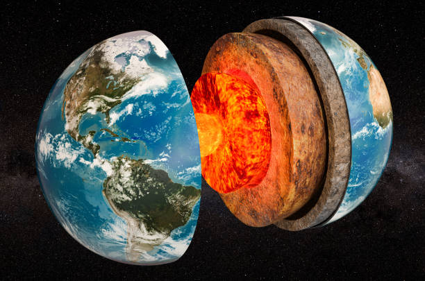
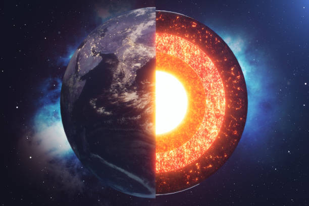
Structure of planet Earth in space, 3D rendering. The source of the map - https://svs.gsfc.nasa.gov/3615
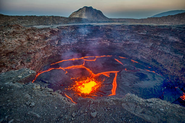
View from the crater rim of Erta Ale - one of the most active vulancoes in the world - into the active, red glowing lava lake. Erta Ale is a continuously active basaltic shield volcano in the Afar Region of northeastern Ethiopia, only some kilometers from the border to Eritrea. The Afar Depression (or Danakil Depression) in the border-triangle between Ethiopia, Eritrea and Djibouti is one of the most remote and most extreme regions of the world - it is the lowest point in Africa (- 155 metres/-550 ft below sea level) and one of the hottest places on Earth. The Danakil/Afar Depression is the product of a tectonic triple junction, where the spreading ridges that form the Red Sea and the Gulf of Aden emerge on land and meet the East African Rift. Here the Earth's crust is slowly rifting apart at a rate of 1–2 centimetres (0.3–0.8 in) per year. Erta ale is ond of the most dangerous places on earth - the lat major eruptions took place in September 2005, August 2007 and November 2008.

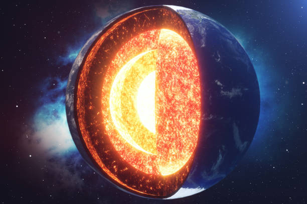
Diagram of the interior layer of Earth. Structure of the Earth infographic.

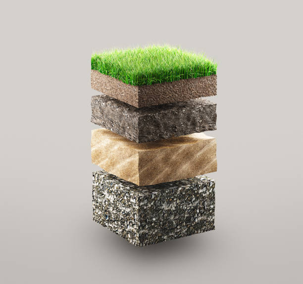
soil, deep, layers, cross, section

Structure of planet Earth with atmosphere layer concept, 3D rendering isolated on white background. The source of the map - https://svs.gsfc.nasa.gov/3615

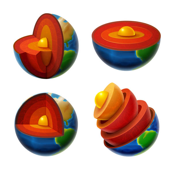
Structure of earth. Diagram of the interior layer of Earth. Geological of earth structure 3d rendering.
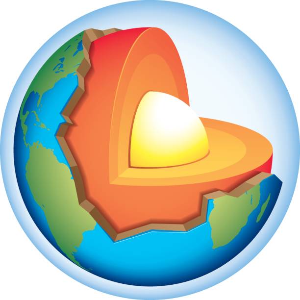
Earth cross section that shows the internal structure with crust, mantle and core.

3D model illustrating layers of earth. Isolated on white with clipping path.World map's obtained from the Nasa public domain archive and then has been modified for required diffuse and bump maps.Link: http://veimages.gsfc.nasa.gov/7100/world.topo.bathy.200401.3x5400x2700.jpgSimilar images:
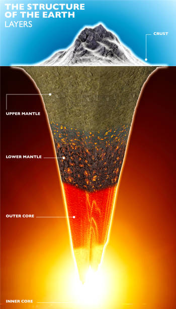
Structure of the Earth, 3d section of the earth. Layers. 3d render. Crust, mantle and core. Cross section, visualization of the composition of the Earth in geological terms

Lithosphere earth layers structure. Planet geology school scheme. Geography infographics with cross section diagram. Earth inside model, internal mantle level. For education and science use.

Portion of land with grass, illustration concept


the earth planet section structure science illustration vector design
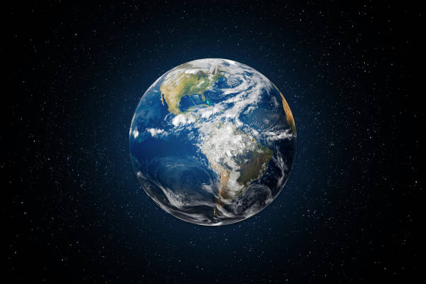
Planet Earth globe view from space with North and South America. This image elements furnished by NASA. https://images.nasa.gov/details-GSFC_20171208_Archive_e002012

Planet layers. World parts geography, geology explanation. Educational diagram. Vector illustration, 3D, clip art.

Illustration graphically describes the problem of the Yellowstone caldera. Question haunting volcanologists around the world. Use in the media, research reports, and where you want.

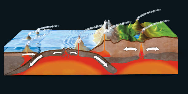
Convergent plate boundary created by two continental plates that slide towards each other. Digital illustration.

3D Isometric Flat Vector Conceptual Illustration of Soil Testing, Natural Resource Study

The layers of the earth concept illustration

Seismic activity diagram. Vector isometric Earth crust compression, shear and tension stresses. Earthquake natural disasters concept for educational poster, scientific infographic, presentation.


Soil layers diagram earth texture, stones. Ground with green grass on top. Mineral particles, sand, humus and stones, natural fertilizer. Geology infographics. Education for kids. Vector illustration.

Earth I have used http://legacy.lib.utexas.edu/maps/world_maps/world_physical_2015.pdf address as the reference to draw the basic map outlines with Illustrator CS5 software, other themes were created by myself.
Layers of ground with grass, illustration concept

Vector natural landscapes or landmarks set. Linear icons of tourist sightseeing. Death and Yosemite valleys, Rushmore memorial, Bryce canyon, Swiss national park, The Matterhorn, Adam's peak.

Cross section planet Earth. Structure of the Earth. Vector illustration Set.

Hillside with a piece of redisch earth`s crust.


internal geological structure of the earth separated into layers isolated over a white background. 3D rendering

Oil and Gas Production Facilities.

Earth structure infographic educational scheme names set isometric vector illustration. Global planet layers inside center section dept geology studying solid level inner outer core lower mantle crust

Soil earth layer section dirt ground geology crust abstract concept. Vector graphic design illustration

Earth core structure with geological layers 3d rendering
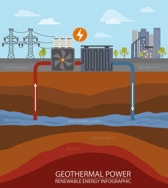
Renewable energy infographic. Geothermal power. Global environmental problems. Vector illustration

Earthquake. seismic activity: Seismic waves, fault, focus and epicenter earthquake
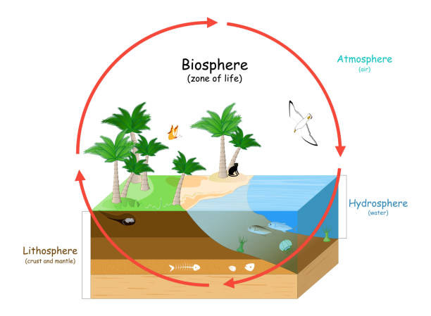
Biosphere is a zone of life on Earth. natural ecosystems with wildlife. Ecosphere (environment), Hydrosphere (water), Atmosphere (air), and Lithosphere (crust and the portion of the upper mantle). vector illustration for education
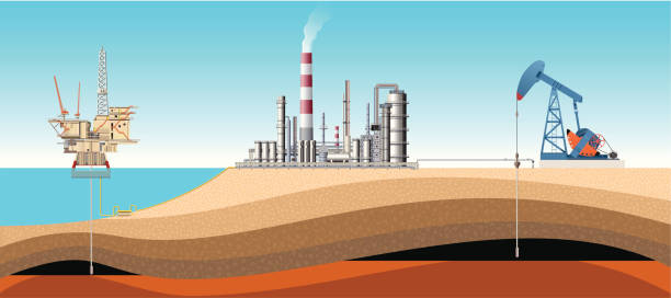
Oil and Gas Production Facilities.

Plate tectonics on the planet Earth. Pangaea. Continental drift. Supercontinent at 250 Ma. Era of the dinosaurs. Jurassic period. Mesozoic. Hand drawn sketch for typography. Vintage engraving style
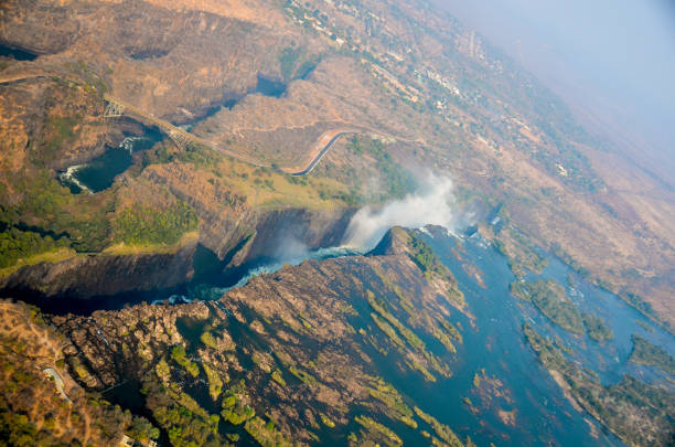
The Zambezi River in southern Africa has eroded the basalt and sandstone rock to form great chasms and cracks, as well as the largest sheet of falling water in the world, Victoria Falls waterfall. Shot from a helicopter flight in August 2013.
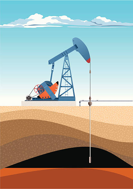
Oil and Gas Production Facilities.

Planet Earth 3D globe with atmosphere and city lights from the deep space at night. Textured collage mixed media design illustration with Earth, stars, nebula, galaxy. Some elements of this image furnished by NASA

Hand-drawn vector drawing of a Plate Tectonics Diagram for converging Plates, Mountain Forming. Black-and-White sketch on a transparent background (.eps-file). Included files are EPS (v10) and Hi-Res JPG.

Lithosphere earth layers structure. Planet geology school scheme. Geography infographics with cross section diagram. Earth inside model, internal mantle level. For education and science use.


layers of the earth orbiting in space
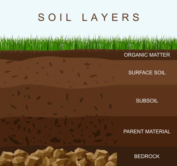
Soil layers diagram earth texture, stones. Ground with green grass on top. Mineral particles, sand, humus and stones, natural fertilizer. Geology infographics. Education for kids. Vector illustration.

Earth cross-section

Uranus internal structure. cross section of planet from core to mantle and crust. Titania is Moon of Uranus. Solar system. infographics. vector diagram. Easy to edit


Beautiful natural landscape. A dip in the Earth's crust. Beautiful ravine. Alexandrovsky graben in the Volgograd region

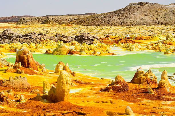
The volcanic explosion crater of Dallol in the Danakil Depresseion in Nothern Ethiopia. The Dallol crater was formed during a phreatic eruption in 1926. This crater is known as the lowest subaerial vulcanic vents in the world. The surreal colours are caused by green acid ponds and iron oxides and sulfur.

Planet Earth dripping from overturned ice cream cone on beige background. Minimal abstract melting scene. Creative idea of global warming or climate change. Dystopian concept. World provided by NASA. https://earthobservatory.nasa.gov/images/565/earth-the-blue-marble
Next