Small vehicle convoy amongst vast Helmand mountains
Browse 3,300+ hindu kush range stock photos and images available, or search for hinduism to find more great stock photos and pictures.
Small vehicle convoy amongst vast Helmand mountains

Aybak /Samangan, Samangan Province, Afghanistan: Haibak or Aibak (from Uzbek 'cave dwellers') is the capital of the northern Afghan province of Samangan, as well as the name of the surrounding district. The city lies on the river Cholm at an altitude of 959 meters, has over 30,000 inhabitants. Mentioned by Ptolemy as the place of the Varni or Uarni and the fortified city of Samangan on the banks of the Khulm River. Founded by Eucratides I, the King of Bactria, it was then known as Eukratidia. During the Kushan Dynasty it was a famous Buddhist centre (Takht-e Rustam). Ancient caravan stop on the silk road.

The beautiful portrait of a handsome man at the Cold Katpana Desert in Karakoram range at the sunset

Khyber Pass, Peshawar, Khyber Pakhtunkhwa / Pakistan - Aug 16 2005: The Khyber Pass in northern Pakistan. Vehicles are climbing the Khyber Pass on the Pakistan side. The Khyber Pass is a vital road link from Peshawar, Pakistan to Landi Kotal and Torkham in Afghanistan

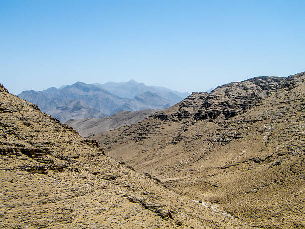
The Baba Mountain range of the Hindu Kush between Kabul and Kandahar in Afghanistan

3D Render of a Topographic Map of Afghanistan. Version with Country Boundaries. All source data is in the public domain. Color texture: Made with Natural Earth. http://www.naturalearthdata.com/downloads/10m-raster-data/10m-cross-blend-hypso/ Relief texture: NASADEM data courtesy of NASA JPL (2020). URL of source image: https://doi.org/10.5067/MEaSUREs/NASADEM/NASADEM_HGT.001 Water texture: SRTM Water Body SWDB: https://dds.cr.usgs.gov/srtm/version2_1/SWBD/ Boundaries Level 0: Humanitarian Information Unit HIU, U.S. Department of State (database: LSIB) http://geonode.state.gov/layers/geonode%3ALSIB7a_Gen

Vintage illustration Panoramic view of the approach to the Khyber Pass, Plain of Jalalabad from Torsupper, 1890s, 19th Century

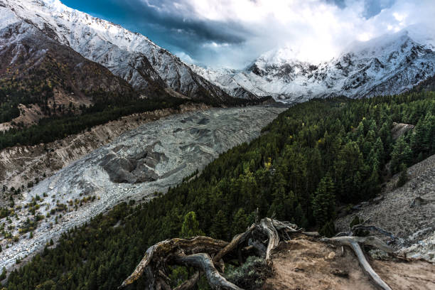
Attabad Lake in Northern Pakistan, formed through a Land Slide in 2010, taken in August 2019, post processed in HDR

The Baba Mountain range of the Hindu Kush between Kabul and Kandahar in Afghanistan

Shot from inside armed vehicle on mission in Helmand Afghanistan

The Kalasha Valleys are valleys in Chitral District in northern Pakistan. The valleys are surrounded by the Hindu Kush mountain range. The inhabitants of the valley are the Kalash people, who have a unique culture, language and follow a form of ancient Hinduism.As such, the Kalasha Valleys are a source of attraction for Pakistanis as well as International tourists.

Silhouetted special forces soldier sunset shot

Evening view of Hindukush or Hindu kush mountain ridge, Tahikistan and Afghanistan, Wakhan corridor, Pamir highway or pamirskij trakt

buddhist, afghanistan, buddha, cave, temple, bamyan, taliban, hindu kush

Stunning view of Passu cathedral peak, north Gulmit Village in Hunza Valley Attabad Lake Pakistan

Hunza River and Passu Cones in Northern Pakistan, taken in August 2019, post processed in HDR

Nanga Parbat, the killer mountain from Raikot sarai, Pakistan
Khulm district, Balkh Province, Afghanistan: snow covered peak - north side of the Hindu Kush range.

Khunjerab Pass, the highest border crossing in the world between Pakistan and China, taken in August 2019, post processed in HDR

Overload decorated Truck from Pakistan.

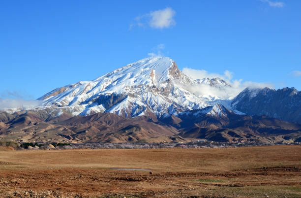
Dalkhaki, Wilayat-e Samangan, Afghanistan: the snow capped Dalkhaki peak (Koh-e Dalkhaki) and the foothills town of Dalkhaki with its mud brick houses, seen from the AH-76 road, north of Aybak.

Attabad Lake in Northern Pakistan, formed through a Land Slide in 2010, taken in August 2019, post processed in HDR

Woman in Katpana Desert in Northern Pakistan on the background of Karakoram mountains

bamyan, afghan, canyon, lake, band amir, band, e, amir, hindu kush, afghanistan, balkhab, balkh, river

Band-e-amir is a famous lake which is located in Bamyan Province and its made of 7 lakes which it water is from Hindukush range

Evening view of hindukush or hindu kush mountain ridge, Tahikistan and afghanistan, view from Pamir highvay or pamirskij trakt

Khyber Pass is the ancient route to Afghanistan from Pakistan and is the means of business still between these two countries. It is considered the gate way to Central Asia. When English ruled the Indo Pak sub continent this highway was built and still famous and know for its historic scenic look through the mountains of this region.

Vintage illustration Death of General Sir Henry Havelock-Allan, Bringing the body down the Khyber Pass, Victorian Military History, 19th Century. Lieutenant General Sir Henry Marshman Havelock-Allan, 1st Baronet VC a British soldier and politician. He was killed by Afridi clansmen on the Afghanistan side of the Khyber Pass in 1897 and he was later buried in Rawalpindi.

Mingora, Pakistan - 01 Apr 2021: A small river in Mingora, Swat valley of Himalayas, Pakistan

Mountain peak in Northern area of Pakistan
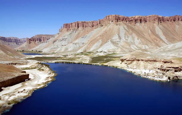
Band-e Amir lakes near Bamyan (Bamiyan) in Central Afghanistan. The blue lakes at Band e Amir national park are formed by travertine dams. Travertine wall, lake and mountains, Band e Amir, Afghanistan

Skardu Katpana Cold Desert in Northern Pakistan, taken in August 2019, post processed in HDR

sandstone, cliff, afghanistan, cave, bamiyan, hindu kush, afghan

Band-e-amir is a famous lake which is located in Bamyan Province and its made of 7 lakes which it water is from Hindukush range

Kholm / Khulm / Tashqurghan, Balkh province, Afghanistan: snow capped mountain peak embraced by a cloud and the crenulated walls of the Jahan Nama Palace, built in 19th century for Emir Abdur Rahman Khan.

bamyan, bamiyan, bamian, afghanistan, taliban, buddha, hazara, hindu kush, islamic, muslim, afghan, unesco

ruin, afghanistan, buddha, bamiyan, buddhism, buddhist, hindu kush

Khorog, Tajikistan August 24 2018: Offroad car and truck on the Pamir Highway in a canyon in the Wakhan valley in Tajikistan (Afghanistan on the left side)

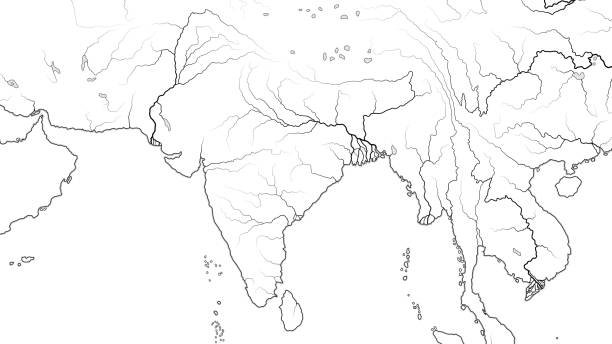
The meeting point of Himalaya, Karakoram and Hindu Kush mountain range, also Indus and Gilgit River, Gilgit-Baltistan, Pakistan.

Mazar-i-Sharif, Balkh province, Afghanistan: city skyline - traditional adobe houses and modern buildings with the mountains in the background. Mazar-e-Sharif is the fourth largest city in Afghanistan, the name of the city means 'Tomb of the Exalted' and refers to the presumed burial place of Ali ibn Abi Talib, cousin and son-in-law of Muhammad, honored by Sunnis, Shiites and Alevis. Historically part of Bactria and the ancient region of Khorasan.

Pale peach of dawn with morning mist obscuring the furthest range of mountains, while the others in mid and foreground are in stark relief. The romance and wild, exotic nature of the Khyber pass, with no one in sight.
© 2025 iStockphoto LP. The iStock design is a trademark of iStockphoto LP. Browse millions of high-quality stock photos, illustrations, and videos.
Do Not Sell or Share