
Rockingham County New Hampshire Pictures, Images and Stock Photos
Browse 10+ rockingham county new hampshire stock photos and images available, or start a new search to explore more stock photos and images.
Most popular
Highly-detailed New Hampshire county map. Each area is in a separate labeled layer. All layers have been alphabetized for easy manipulation, recoloring or other use. (see image below -- note: labels only available in AICS2 and AI10 files)

Highly-detailed New Hampshire county map. Each county is in it's own separate labeled layer. County names are in a separate layer and can be easily adjusted or removed as well. All layers have been alphabetized for easy manipulation, recoloring or other use.

NH Rockingham Londonderry Vector Road Map. All source data is in the public domain. U.S. Census Bureau Census Tiger. Used Layers: areawater, linearwater, roads, rails, cousub, pointlm, uac10.

NH Rockingham Auburn Vector Road Map. All source data is in the public domain. U.S. Census Bureau Census Tiger. Used Layers: areawater, linearwater, roads, rails, cousub, pointlm, uac10.
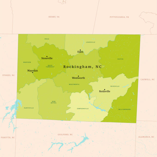
NC Rockingham County Vector Map Green. All source data is in the public domain. U.S. Census Bureau Census Tiger. Used Layers: areawater, linearwater, cousub, pointlm.

Map of Rockingham County - North Carolina, with a large group of people. The faces are blue and red and represent patriots. The color blue for the Democratic Party and the color red for the Republican Party. Conceptual creative map, can symbolize the unity, cooperation, teamwork, patriotism... Vector Illustration (EPS file, well layered and grouped). Easy to edit, manipulate, resize or colorize. Vector and Jpeg file of different sizes.

Map of Rockingham County - New Hampshire, on a blue and red colored background. The blue color represents the Democratic Party and the red color represents the Republican Party. White stars are placed above and below the map. Vector Illustration (EPS file, well layered and grouped). Easy to edit, manipulate, resize or colorize. Vector and Jpeg file of different sizes.

Map of Rockingham County - North Carolina, with a realistic paper cut effect isolated on white background. Trendy paper cutout effect. Vector Illustration (EPS file, well layered and grouped). Easy to edit, manipulate, resize or colorize. Vector and Jpeg file of different sizes.

Map of Rockingham County - New Hampshire, with a realistic paper cut effect isolated on white background. Trendy paper cutout effect. Vector Illustration (EPS file, well layered and grouped). Easy to edit, manipulate, resize or colorize. Vector and Jpeg file of different sizes.

Map of Rockingham County - North Carolina, for your own design. Four maps with editable stroke included in the bundle: - One black map on a white background. - One blank map on a black background. - One white map with shadow on a blank background (for easy change background or texture). - One line map with only a thin black outline (in a line art style). The layers are named to facilitate your customization. Vector Illustration (EPS file, well layered and grouped). Easy to edit, manipulate, resize or colorize. Vector and Jpeg file of different sizes.

Map of Rockingham County - North Carolina, isolated on a blank background and with his name on a red ribbon. Vector Illustration (EPS file, well layered and grouped). Easy to edit, manipulate, resize or colorize. Vector and Jpeg file of different sizes.

Map of Rockingham County - New Hampshire, for your own design. Four maps with editable stroke included in the bundle: - One black map on a white background. - One blank map on a black background. - One white map with shadow on a blank background (for easy change background or texture). - One line map with only a thin black outline (in a line art style). The layers are named to facilitate your customization. Vector Illustration (EPS file, well layered and grouped). Easy to edit, manipulate, resize or colorize. Vector and Jpeg file of different sizes.

Map of Rockingham County - New Hampshire, isolated on a blank background and with his name on a red ribbon. Vector Illustration (EPS file, well layered and grouped). Easy to edit, manipulate, resize or colorize. Vector and Jpeg file of different sizes.

Map of Rockingham County - New Hampshire, with a large group of people. The faces are blue and red and represent patriots. The color blue for the Democratic Party and the color red for the Republican Party. Conceptual creative map, can symbolize the unity, cooperation, teamwork, patriotism... Vector Illustration (EPS file, well layered and grouped). Easy to edit, manipulate, resize or colorize. Vector and Jpeg file of different sizes.

Map of Rockingham County - North Carolina, on a blue and red colored background. The blue color represents the Democratic Party and the red color represents the Republican Party. White stars are placed above and below the map. Vector Illustration (EPS file, well layered and grouped). Easy to edit, manipulate, resize or colorize. Vector and Jpeg file of different sizes.