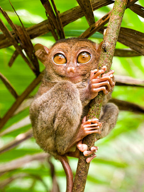
Tarsier - (lat) Tarsius Syrichta - small primate with large eyes found on the island of Bohol in the Philippines
Browse 320+ samar stock photos and images available, or search for sima samar to find more great stock photos and pictures.
Tarsier - (lat) Tarsius Syrichta - small primate with large eyes found on the island of Bohol in the Philippines

San Juanico Bridge: The Longest Bridge in the Philippines. Road bridge between the islands, top view. Summer and travel vacation concept.

Tarsier des Philippines

Road bridge on the island of Samar, Philippines. Bridge over the river, tropical landscape in the afternoon. Summer and travel vacation concept.
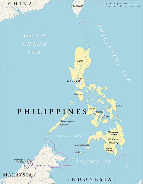
Philippines Political Map with capital Manila, national borders, most important cities, rivers and lakes. English labeling and scaling. Illustration.

Map of Manila, Philippines. Detail from the World Atlas.

The Philippines political map with capital Manila. English labeling. Republic and sovereign island country in Southeast Asia in the Western Pacific Ocean. Gray illustration on white background. Vector

Map of Samar in realistic white frame isolated on blank wall (colors used: blue, green, gray and white). Vector Illustration (EPS10, well layered and grouped). Easy to edit, manipulate, resize or colorize.

The San Juanico Bridge, view from Leyte, towards Samar. Philippines. Road bridge between the islands, top view.

Philippines, Samar, surfing, Pacific Ocean.
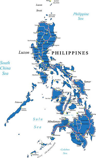
Highly detailed map of Philippines.

River and green hills. Beautiful natural scenery of river in southeast Asia. Countryside on a large tropical island. Small village on the green hills by the river. The nature of the Philippines, Samar

View over the majestic island Samar on the Philippines January 19, 2012

Cartoon map of Philippineshttps://maps.lib.utexas.edu/maps/islands_oceans_poles/philippines.gif

Philippines, Samar, coconut palms, surfers on beach.

Panoramic of San Juanico Bridge, the longest bridge in the Philippines. Road bridge between the islands, top view. Summer and travel vacation concept.

Highly detailed physical map of Philippines,in vector format,with all the relief forms,regions and big cities.

Road bridge on the island of Samar, Philippines.Town on the river bank and road bridge, top view. Bridge over the river, tropical landscape in the afternoon. Summer and travel vacation concept.

San Juanico Bridge: The Longest Bridge in the Philippines. Road bridge between the islands, top view. Summer and travel vacation concept.

"The San Juanico Bridge, view from Samar, towards Leyte. Philippines"

Cartoon map of Philippineshttps://maps.lib.utexas.edu/maps/islands_oceans_poles/philippines.gif

Tropical landscape in sunny weather. Village by the river. Green hills and river. Summer and travel vacation concept. The nature of the Philippine Islands.

San Juanico Bridge is a bridge connecting Samar and Leyte in the Philippines, making travel easy from one island to another.

Hand writing "Help Rebuild The Philippines", isolated on white background.

Tropical landscape in sunny weather. Village by the river. Green hills and river. Summer and travel vacation concept. The nature of the Philippine Islands.

Calbayog, Samar, Philippines - Marju Krisel Resort, a hotel in Calbayog City.

Rusty old ferry ship in Samar on the Philippines January 22, 2012

Birgu, Malta - April 24, 2015: The luxury motor yacht with helicopter. More then 1,6 mln tourists is expected to visit Malta in year 2015.

Map of Samar in a trendy vintage style. Beautiful retro illustration with old textured paper and light rays in the background (colors used: blue, green, beige and black for the outline). Vector Illustration (EPS10, well layered and grouped). Easy to edit, manipulate, resize or colorize.

Tarsier des Philippines

Tarsier des Philippines

"The San Juanico Bridge, view from Samar, towards Leyte. Philippines"

Monbon Island sits on a protected sanctuary of diverse marine species. It is located in Borongan City, Philippines.

River and green hills. Beautiful natural scenery of river in southeast Asia. Countryside on a large tropical island. Small village on the green hills by the river. The nature of the Philippines.

San Juanico Bridge: The Longest Bridge in the Philippines. Road bridge between the islands, top view. Summer and travel vacation concept.

Map of Samar drawn in chalk on a green chalkboard with chalk traces. Vector Illustration (EPS10, well layered and grouped). Easy to edit, manipulate, resize or colorize.

Philippines, Samar, coastline, Pacific Ocean.

Calbayog, Samar, Philippines - Sept 2022: A pedicab driver transports a passenger through streets of downtown Calbayog.

The scimitar horned addax (Addax nasomaculatus) is originally from the region of the Sahara Desert

Arabian Oryx in the desert of Eilat

Catbalogan, Samar, Philippines - Sept 2022: The Catbalogan Doctors Hospital.

Calbayog, Samar, Philippines - Sept 2022: A pedicab driver transports a passenger through streets of downtown Calbayog.

Calbayog, Samar, Philippines - Sept 2022: Pedicab driver ply a route in the streets of downtown Calbayog.

Calbayog, Samar, Philippines - Sept 2022: A pedicab driver transports a passenger through streets of downtown Calbayog.

An aerial shot of Pacific waves surging onto rocky outcrop along the coastline of Biri Island, Northern Samar, Philippines

The nature of the Philippine Islands, Samar. Mountains and hills in clear weather. Tropical landscape with green hills, aerial view.
Map of Samar with a red arrow moving down on a white checkered background. Conceptual image. Vector Illustration (EPS10, well layered and grouped). Easy to edit, manipulate, resize or colorize.

Bridge Engineering: Steel Girder Viaduct With Arch-Shaped Truss

Map of Samar for your own design. With space for your text and your background. Four maps included in the bundle: - One black map. - One blank map with only a thin black outline (in a line art style). - One mosaic map. - One white map with a thin black outline. The 4 maps are isolated on a blank background (for easy change background or texture).The layers are named to facilitate your customization. Vector Illustration (EPS10, well layered and grouped). Easy to edit, manipulate, resize or colorize.


