Danube River Serbia stock illustrations
Browse 160+ danube river serbia stock illustrations and vector graphics available royalty-free, or start a new search to explore more great stock images and vector art.
Most popular
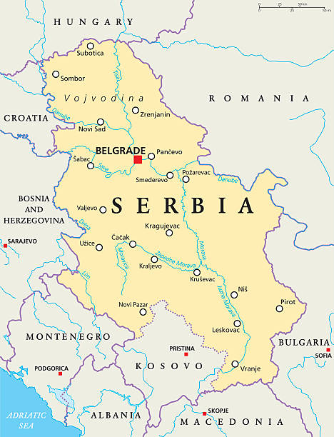
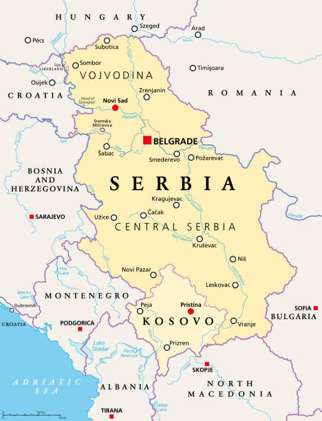
Serbia political map with capital Belgrade, national borders, important cities, rivers and lakes. English labeling and scaling. Illustration.
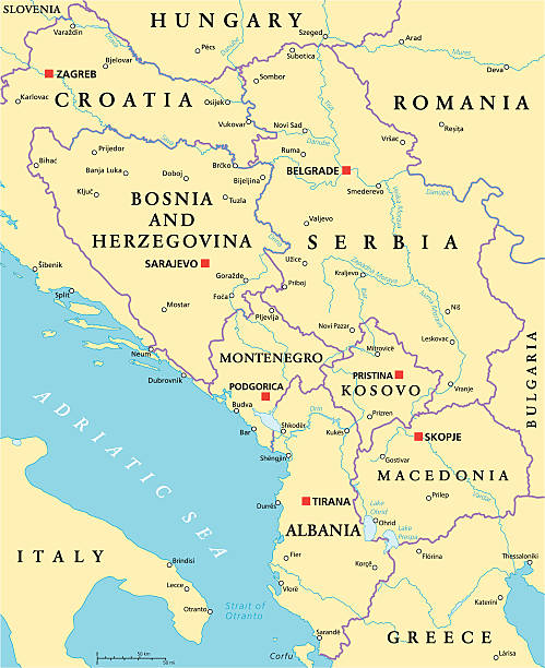
Central Balkan Political Map formed by Bosnia and Herzegovina, Serbia, Montenegro, Kosovo, Albania and Macedonia. With capitals, national borders, important cities, rivers and lakes. English labeling and scaling.
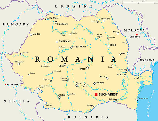
Romania political map with capital Bucharest, national borders, important cities, rivers and lakes. English labeling and scaling. Illustration.
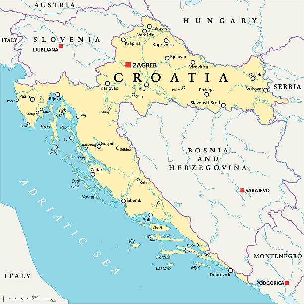
Croatia Political Map with capital Zagreb, national borders, important cities, rivers and lakes. English labeling and scaling. Illustration.
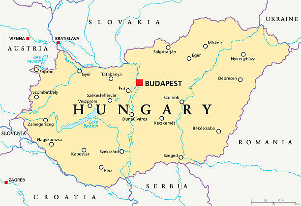
Hungary political map with capital Budapest, national borders, important cities, rivers and lakes. English labeling and scaling. Illustration.


Bulgaria vector map with major cities and rivers
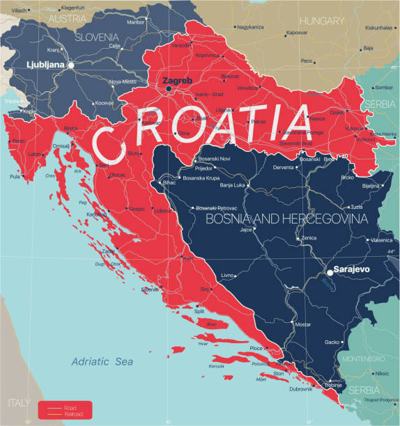
Croatia country detailed editable map with regions cities and towns, roads and railways, geographic sites. Vector EPS-10 file

Outline Skyline panorama of City of Belgrade, Serbia - vector illustration

Illustration of Augarten Bridge and Rudolf Barracks

Silhouette Skyline panorama of City of Belgrade, Serbia - vector illustration

Illustration of a Great Bačka Canal (Hungarian: Ferenc-csatorna) is a canal in Serbia which runs from Bezdan (on the Danube) to Bečej (on the Tisa)

Cartoon Skyline panorama of City of Belgrade, Serbia - vector illustration

Tactical Military Emerald 3D Topography Map of European Country of Kosovo


Hungary country detailed editable map with regions cities and towns, roads and railways, geographic sites. Vector EPS-10 file

Illustration of a Budapest city map


Outline Skyline panorama of City of Belgrade, Serbia - vector illustration
Serbia and Kosovo, landlocked countries in Southeast Europe, political map. The Republic of Serbia, with capital Belgrade, and Republic of Kosovo, partially recognized country, with capital Pristina.

Geological map of the Austro-Hungarian Empire. Lithograph, published in 1897.

Historic city map of Belgrade - capital and largest city of Serbia. Wood engraving, published in 1897.

Illustration of a Valens and Athanaric in the year 369 on the Danube

Illustration of a Starý most (English: Old Bridge) is a bridge over the river Danube in Bratislava, Slovakia

Flag of Yugoslavia. Vector illustration on white background. Beautiful brush strokes. Abstract concept. Elements for design."n

Pannonia is an ancient country of southern Europe that was south and west of the Danube River, in present-day Austria, Hungary, Slovenia, and Croatia.

Illustration of a Marcomannic Wars 166 - 180, Roman troops crossing the Danube, Emperor Marcus Aurelius meeting envoys

Sunset Skyline panorama of City of Belgrade, Serbia - vector illustration

Vector - the municipalities in Belgrade

Illustration of a Danube at Mohacs

Sanjak region in Serbia and Montenegro, detailed editable map with regions cities and towns, roads and railways, geographic sites. Serbia Kosovo and Montenegro map. Vector EPS-10 file

Illustration of a Pest old map

Illustration of a Zemun (Serbian Земун (Cyrillic) or Zemun (Latin), Za·munt (Romanian), Hungarian Zimony and German Semli) is a municipality of the city of Belgrade. Zemun was a separate town that was absorbed into Belgrade in 1934

Illustration of a Coat of arms of János Hunyadi

Illustration of a Orsova is a port city on the Danube river in southwestern Romania's Mehedinți County

Colourfull Skyline panorama of City of Belgrade, Serbia - vector illustration


Illustration of a Danube river

“Budapest,” famously, is the combination of the cities Buda and Pest

Croatia-Serbia border dispute, political map. Yellow marked Danube area under Serbian control, but claimed by Croatia. Two areas of no mans land are claimed by the micronations Liberland and Verdis.

Illustration of a Hungary, Budapest, Buda castle, late 16th century, exterior view

Illustration from the March 1876 issue of Harper's New Monthly Magazine depicts a barge on the Danube River as it passes Belgrade, Capital of Serbia.

Illustration of a Tunnel to the Chain Bridge in 1931


Historical view of the Iron Gates near Orsova - a gorge on the river Danube. It forms part of the boundary between Serbia (to the south) and Romania (north). Until it was defused in 1972 in connection with the Iron Gate 1 power plant, it was considered the most dangerous section of the Danube for shipping and could not be crossed without local pilots. For decades, ships were towed upriver by locomotives. Wood engraving, published in 1894.

Illustration of The Grand Hotel in Berchtesgaden and its surroundings

Map of Donau river drainage basin. Simple thin outline vector illustration.

Black Location Map of Kosovar District of Gjakova within Grey Map of Kosovo

Colored Labeled Districts Map of European Country of Kosovo

White Districts Map of European Country of Kosovo

Grey Districts Map of European Country of Kosovo

White Labeled Districts Map of European Country of Kosovo

Black Location Map of Kosovar District of Mitrovica within Grey Map of Kosovo

Black Location Map of Kosovar District of Ferizaj within Grey Map of Kosovo

Black Location Map of Kosovar District of Prizren within Grey Map of Kosovo

Black Location Map of Kosovar District of Gjilan within Grey Map of Kosovo

Black Location Map of Kosovar District of Pristina within Grey Map of Kosovo

Black Location Map of Kosovar District of Peja/Peć within Grey Map of Kosovo

Illustration of a King Matthias and Beatrice of Aragon. The son of John Hunyadi, Matthias died in 1690 leaving no heir and failing to create a great Danube kingdom
Next