Ottoman Map stock illustrations
Browse 310+ ottoman map stock illustrations and vector graphics available royalty-free, or search for ottoman empire to find more great stock images and vector art.
Most popular
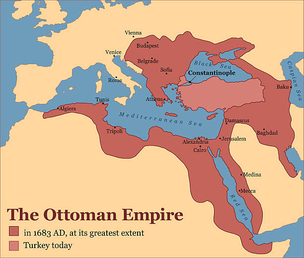
The Ottoman Empire at its greatest extent in 1683, and Turkey today. Vector illustration.
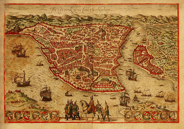
Old engraving depicting map of Constantinopolis (Istanbul), the capital of the Byzantine and the Ottoman empires. Printed in 1572 by Braun and Hogenberg in Civitates Orbis Terrarum. Photo by N. Staykov (2007)Click on thumbnails below for more images of Istanbul:
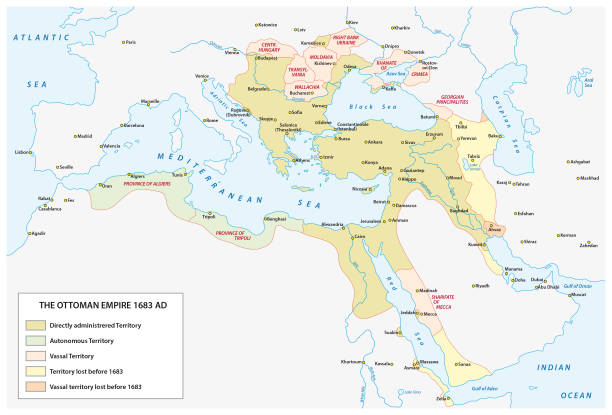
Vector map of the Ottoman Empire at the time of the greatest expansion and in the late 17th century

Ancient map of Ottoman Empire. Lithograph, published in 1878.
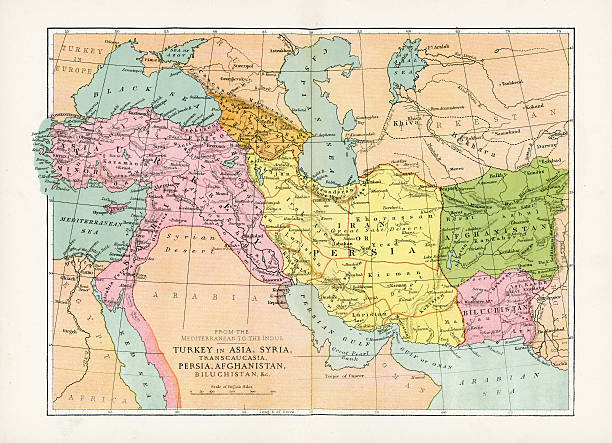
Vintage map of Turkey in Asia, Transcaucasia, Persia, Afghanistan, Biluchistan etc, from 1894
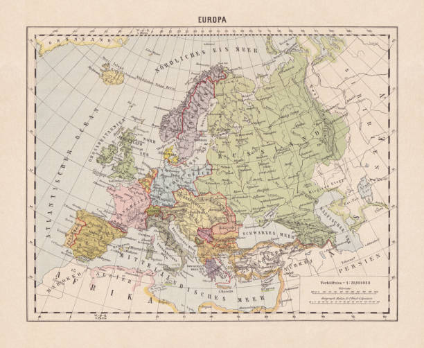
Political map of Europe. Descriptions in German. Lithograph, published in 1893.

vector map of the ottoman empire for your design
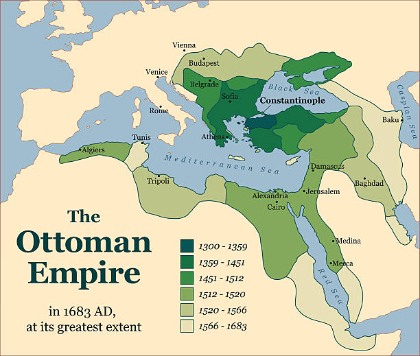
The Ottoman Empire at its greatest extent in 1683. Vector illustration.

Antique illustration of a Historical map of the Oriental part of world

City map of Constantinople (Istanbul, Turkey). Lithograph, published in 1897.
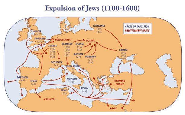
Map showing the expulsion of Jews and their resettlement between 1100 and 1600

Old map of Romania and Bulgaria. Steel engraving with hand coloured borderline, published in 1857.

Ancient map of the history of European Turkey, 15th - 19th century. Lithograph, published in 1878.

Vintage map of Turkey in Europe and Greece in 1861
Vector map of Europe at the start of the first world war in 1914 with clear borders.

Map of the battle situations during the Greco-Turkish War (Thirty Days' War) in 1897. Wood engraving, published in 1898.

The Ottoman Empire at its greatest extent in 1683. German labeling! Vector illustration.

Vintage map of Turkey in Europe, Greece, Montenegro and the Danubian Principalities, from 1894

The Great Turkish War between the Holy League of European Powers and the Ottoman Empire, also known as the Great Turkish War of Leopold I or the 5th Austrian Turkish War, lasted from 1683 to 1699. Under its new Grand Vizier and Commander-in-Chief Kara Mustafa, the Ottoman Empire tried for the second time in 1683 (after the first Turkish siege of Vienna in 1529) to conquer the imperial city of Vienna and to open the gate to Central Europe. The failure of this siege led to the imperial counter-offensive, in the course of which the Ottomans were expelled from the territory of the Kingdom of Hungary and the tripartite division of Hungary in favor of the Habsburgs came to an end. Illustration from 19th century.

Antique map of Greece from 1867

Antique map of Turkey from 1867

Historical map of the Balkan Peninsula, late 19th century. Explanations in German. Lithograph, published in 1893.

Engraved illustrations of the Turkish Empire from Iconographic Encyclopedia of Science, Literature and Art, Published in 1851. Copyright has expired on this artwork. Digitally restored.

Vintage engraving of a Antique map of Turkey, 1897, late 19th Century

Illustration of a Europe after Treaty of Passarowitz or Treaty of Požarevac

The Great Turkish War between the Holy League of European Powers and the Ottoman Empire, also known as the Great Turkish War of Leopold I or the 5th Austrian Turkish War, lasted from 1683 to 1699. Under its new Grand Vizier and Commander-in-Chief Kara Mustafa, the Ottoman Empire tried for the second time in 1683 (after the first Turkish siege of Vienna in 1529) to conquer the imperial city of Vienna and to open the gate to Central Europe. The failure of this siege led to the imperial counter-offensive, in the course of which the Ottomans were expelled from the territory of the Kingdom of Hungary and the tripartite division of Hungary in favor of the Habsburgs came to an end. Illustration from 19th century.

Rare and beautifully executed Engraved illustration of Building the Walls of Jerusalem Biblical Engraving from The Popular Pictorial Bible, Containing the Old and New Testaments, Published in 1862. Copyright has expired on this artwork. Digitally restored.

Vintage map of Asia in the 19th century


Meyers Konversations-Lexikon. Ein Nachschlagewerk des allgemeinen Wissens, 5th edition 17 volumes Bibliographisches Institut - Leipzig 1895-1897
Vector illustration
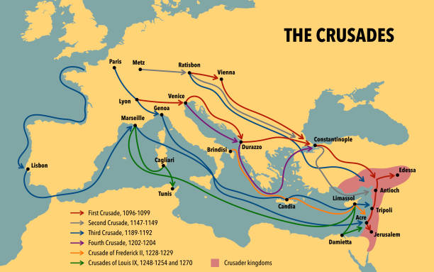
Map of the Crusades main routes and roads

Maps of the historical development of Poland, Prussia (Teutonic Order), Lithuania and Western Russia from the 10th to the 18th century. Lithograph, published in 1897.

vector map of The Great Seljuk Empire for your project

Medieval map of the Balkan peninsula in EuropeCLICK ON THE LINKS BELOW FOR HUNDREDS MORE SIMILAR IMAGES:
Vector map of europe after signing the treaty of Versailles with clear country borders

vector map of the British Empire

Vintage illustration, Antique map of Turkey in Asia, Ottoman, Arabia, Persia, detail on Aden, 19th Century, 1890s

Illustration for technology design or infographics. Isolated on white background. Vector eps 10

Vector Istanbul, you are Here http://legacy.lib.utexas.edu/maps/navymaps/istanbul.html

Antalya districts Dosemealti, Korkuteli, Kepez, Serik, İbradi, Akseki, Gundogmus, Alanya, Gazipasa, Konyalalti, Muratpasa, Aksu, Manavgat, Kemer, Kumluca, Finike, Demre, Kas, Elmali map, Turkey


Historical map of Constantinople, Ottoman Empire (Istanbul, Turkey). Explanations in German. Wood engraving, published in 1893.

Historical city map of Smyrna (Izmir), Turkey. Wood engraving, published in 1897.

Engraving of East Europe Map. Steel engraved antique print from the Turkey volume of L'Univers (Universe/Turkey), dated 1840. Balkans, Eastern Europe, Balkans, Bosnia, Albania, Bulgaria, Adriatic, Transylvania, Dalmatia, Turkey,

Vector Edirne Travel Map

Old topographic map of Asia Minor (Turkey). Lithograph, published 1897.

Hatay districts erzin, arsuz, dortyol, payas, iskenderun, belen, samandag, defne, antakya, yayladagi, altinozu, reyhanli, kumlu, kirikhan, hassa map, Turkey

Bursa districts gursu, gemlik, yildirim, nilufer, mudanya, karacabey, osmangazi, mustafakemalpasa, buyukorhan, orhaneli, harmancik, keles, inegol, kestel, yenisehir, iznik, orhangazi map, Turkey

izmir districts dikili, bergama, cesme, aliaga, foca, konak, balcova, narlidere, karaburun, urla, seferihisar, gaziemir, buca, torbali, selcuk, tire, odemis, beydag, bergama, cigli,bornova map, Turkey

Canakkale districts Gelibolu, Eceabat, Lapseki, Gokceada, Bozcaada, Ezine, Ayvacik, Can, Bayramic, Yenice, Biga map, Turkey
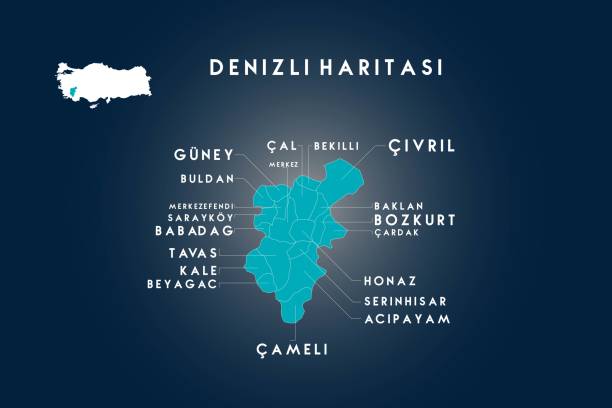
Denizli districts guney, kale, buldan, merkezefendi, saraykoy, babadag, tavas, beyagac, cameli, acipayam, serinhisar, honaz, cardak, bozkurt, baklan, civril, bekilli, cal map, Turkey

vector map of the Byzantine Empire for your design

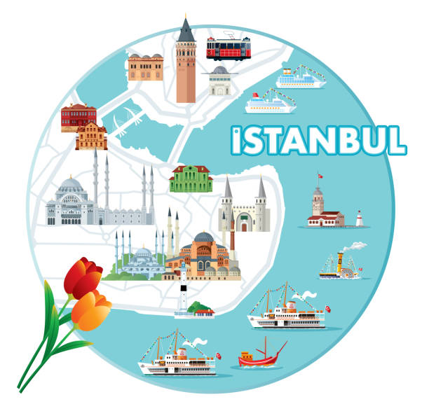
Vector Cartoon Map of ISTANBUL http://legacy.lib.utexas.edu/maps/navymaps/istanbul.html

Rize districts Cayeli, Ardesen, Pazar, Findikli, Guneysu, Kalkandere, iyidere, Derepazari, Camlihemsin, ikizdere, Hemsin map, Turkey


Adana districts Aladag(Karsanti), Ceyhan, Cukurova, Feke, imamoglu, Karaisali, Karatas, Kozan, Pozanti, Saimbeyli, Sarıcam, Seyhan, Tufanbeyli, Yumurtalık, Yuregir map, Turkey

Ancient map Balkan. The political classification of the Balkan Peninsula after the Treaty of Berlin in 1878. Lithograph, published in 1878.

Historical map of European part of the Ottoman Empire (Turkey) at the end of the 19th century. Lithograph, published in 1897.