
Republic Of Mauritius stock illustrations
Browse 3,600+ republic of mauritius stock illustrations and vector graphics available royalty-free, or start a new search to explore more great stock images and vector art.
Most popular
vector illustration of Mauritius map
Stylized simple outline map of Mauritius icon


Mauritius Political Map with capital Port Louis, the islands Rodrigues and Agalega and with the archipelago Saint Brandon. English labeling and scaling. Illustration.

Map of Mauritius Vector Illustration Design Template. Vector eps 10.

Collection of Mauritius flag icons with square, circle, rectangle and map shapes.

Time to travel. Tropical resort poster vintage. Beach coast traditional huts, palms, ocean. Retro style illustration vector isolated

Map of Mauritius for your own design. With space for your text and your background. Four maps included in the bundle: - One black map on a white background. - One blank map on a black background. - One white map with shadow on a blank background (for easy change background or texture). - One blank map with only a thin black outline (in a line art style). The layers are named to facilitate your customization. Vector Illustration (EPS10, well layered and grouped). Easy to edit, manipulate, resize or colorize. Please do not hesitate to contact me if you have any questions, or need to customise the illustration. http://www.istockphoto.com/portfolio/bgblue

Mauritius map with borders, cities, capital and administrative divisions. Infographic vector map. Editable layers clearly labeled.


black vector map of Mauritius


Abstract map of Mauritius geometric mesh polygonal network line, structure and point scales on dark background. Vector illustration eps 10.


Abstract Map of Mauritius from polygonal blue lines and glowing stars on dark blue background. Vector illustration eps10.

Detailed vector illustration of the Mauritius map with navigation icons.

High quality map with borders of the regions


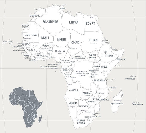
Map of Africa with labeled countries and capital cities. All elements grouped in their own layers, labeled and alphabetized for easy editing. (See screenshot.) EPS 10 file. Transparency effects used longitude and latitude lines.

vector illustration of Mauritius map

Detailed vector map of Mauritius with main cities and roads

Mauritus hand drawn cartoon doodles illustration. Funny travel design. Creative art vector background. Handwritten text with exotic island elements and objects. Colorful composition


Mauritius Flag with Brush Strokes. Vector Illustration. Independence Day.

Light topographic map of the Republic of Mauritius with black contour lines on beige background

Map of Mauritius colored with the flag and marked with a golden line in grunge vintage style.


Mauritius network map. Abstract geometric map of the island. Digital connections and telecommunication design. Glowing internet network. Powerful vector illustration.

Map of Mauritius for your own design. Three maps with editable stroke included in the bundle: - One black map on a white background. - One line map with only a thin black outline in a line art style (you can adjust the stroke weight as you want). - One map on a blank transparent background (for change background or texture). The layers are named to facilitate your customization. Vector Illustration (EPS file, well layered and grouped). Easy to edit, manipulate, resize or colorize. Vector and Jpeg file of different sizes.

Dodo silhouette. A recreation of the extinct dodo in the wild.

Vector illustration. Maldives, travel poster, banner, postcard. Tourism, travel.

Mauritius political map with capital Port Louis, outer islands Agalega, Rodrigues, Saint Brandon. Republic and island nation in the Indian Ocean. Gray illustration over white. English labeling. Vector
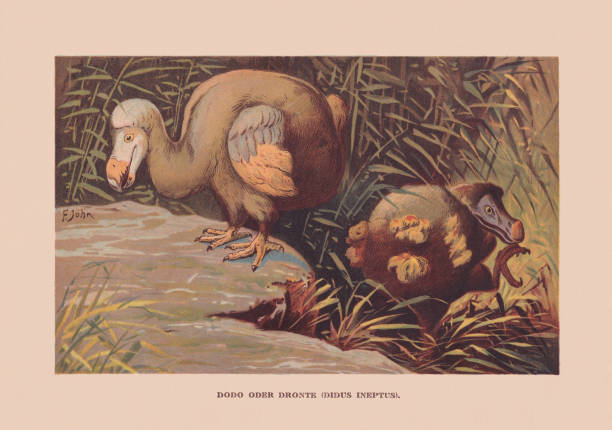
Dodo (Raphus cucullatus, or Didus ineptus) - ca. 1690 extinct, about one meter (3 ft) tall, flightless bird that lived exclusively on the island of Mauritius in the Indian Ocean. Chromolithograph after a drawing by Francis John, published in 1900.

grey dot outline vector triangle map

http://dikobraz.org/map_2.jpg
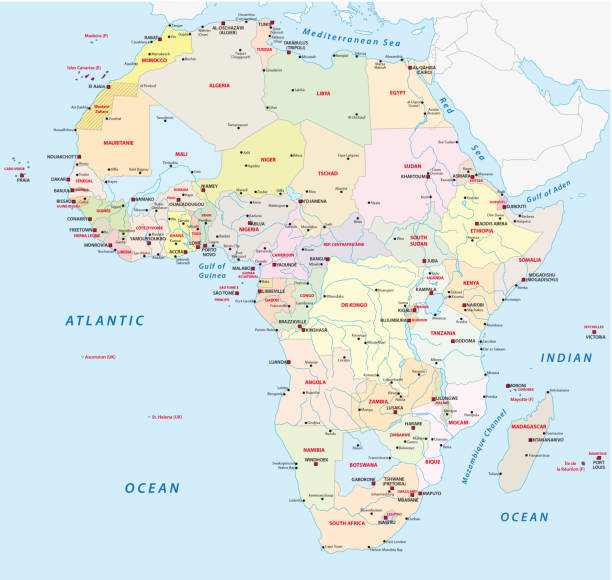
africa administrative and political vector map

Cartoon doodles Mauritus seamless pattern. Backdrop with Mauritian culture symbols and items. Colorful detailed, with lots of objects background for print on fabric, textile, greeting cards, scarves, wrapping paper. All objects separate.


Mauritius 3d map with borders of regions. Vector illustration


Mauritius administrative and political vector map

From top left to bottom right:

vector illustration of Doodle showing Architecture and Culture of China

Maldives travel poster tropical resort vintage. Beach coast beach umbrella straw, palms, ocean, coast. Paradise resort, retro style illustration vector postcard


Map of Mauritius made with round blue dots on a blank background. Original mosaic illustration. Vector Illustration (EPS10, well layered and grouped). Easy to edit, manipulate, resize or colorize. Please do not hesitate to contact me if you have any questions, or need to customise the illustration. http://www.istockphoto.com/portfolio/bgblue

Map of Africa created with a mesh of thin bright blue lines and glowing dots, isolated on a dark blue background. Conceptual illustration of networks (communication, social, internet, ...). Vector Illustration (EPS10, well layered and grouped). Easy to edit, manipulate, resize or colorize.

map silhouette line country Africa map illustration vector outline African isolated on white background


Waving ribbon with flag of Mauritius. Template for independence day poster design
Next