
Suez Canal Ship stock illustrations
Browse 70+ suez canal ship stock illustrations and vector graphics available royalty-free, or start a new search to explore more great stock images and vector art.
Most popular
Cargo vessels traffic jam grows in Suez canal. Maritime traffic jam.

Cargo vessels traffic jam grows in Suez canal

Suez Canal, political map. An artificial sea-level waterway in Egypt, connecting the Mediterranean Sea to the Red Sea, dividing Africa and Asia. It extends from Port Said to Suez. Illustration. Vector
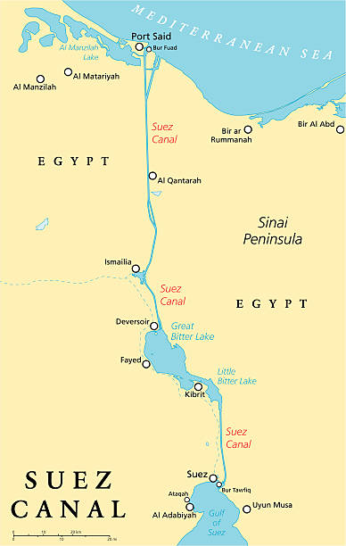
Suez Canal Political Map. Artificial sea-level waterway in Egypt, connecting the Mediterranean Sea and the Red Sea. English labeling and scaling. Illustration.

Suez Canal, gray political map. Artificial sea-level waterway in Egypt, connecting the Mediterranean Sea to the Red Sea, dividing Africa and Asia, extends from Port Said to Suez. Illustration. Vector.

Suez Canal, built to connect the Mediterranean and Red seas, opens November 17, 1869 to navigation. Illustration published in Royal Manual by Henry Davenport Northrop (The Dallas Book Publishing Co.: Dallas, Texas) in 1891. Copyright expired; artwork is in Public Domain.

Antique illustration: Suez Canal


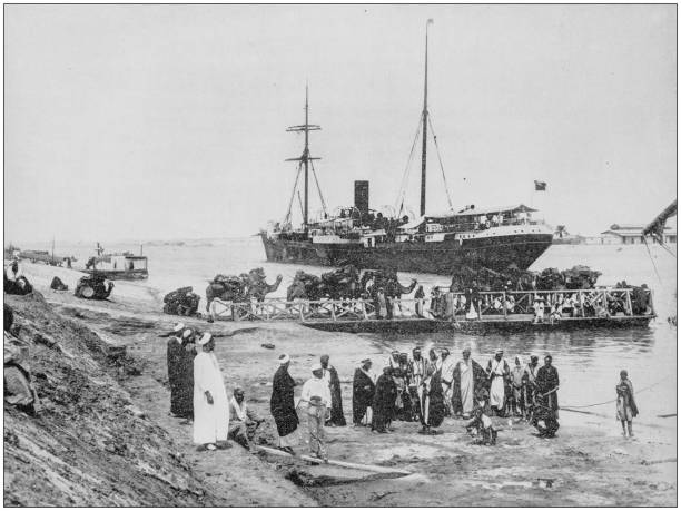
Antique photograph of Port Said on Suez Canal (Egypt) as it was during the 19th century (1880). The city was founded in 1859 along the coast of the Mediterranean Sea, when the Suez Canal was being built. In the picture the important harbor with its buildings (close to the viewer one of Port Said typical big houses with balconies)

Vintage engraving from 1878 showing The Suez Canal with Dredges at Work

Indo-Pacific major energy SLOCs, political map. Geopolitically critical Sea Lines Of Communication. Primary maritime routes between ports, used for trade, logistics and naval forces. Illustration.

The Suez Canal is an artificial sea-level waterway in Egypt. The canal is a route of trade between Europe and Asia. In 1858, Ferdinand de Lesseps formed the Suez Canal Company for the purpose of building the canal. The canal opened 17 November 1869.

Vintage engraving from 1851 showing the opening of the Suez Canal and a procession of ships

Suez canal detailed vector map.

A montage showing the Canadian Pacific Railway and the Suez Canal in Egypt - both constructed during the reign of Queen Victoria and published in a book to celebrate her Golden Jubilee. During the time of the British Empire, they are described as “two short roads to our Eastern Possessions”. From “The Realm of Victoria 1837-1887” by WJ Gordon. Published c1887 to commemorate Queen Victoria’s Golden Jubilee. Publisher Perry & Co, London.

Vintage engraving from 1878 showing a Bird's Eye View of the Suez Canal. Also known by the nickname "The Highway to India", is an artificial sea-level waterway in Egypt, connecting the Mediterranean Sea and the Red Sea. Opened in November 1869 after 10 years of construction work, it allows water transportation between Europe and Asia without navigation around Africa.


Vintage engraving of the Port of Suez. Ferdinand Hirts Geographische Bildertafeln,1886.


Harper's School Geography, New York, Harper's and Brothers, 1881.

Greater Flamingos (phoenicopterus roseus) along the Suez Canal in Egypt. Vintage etching circa 19th century.


Illustration of a A drive through the Suez Canal

Historical aerial view of the construction of the Suez Canal - an artificial sea-level waterway in Egypt, connecting the Mediterranean Sea to the Red Sea through the Isthmus of Suez and dividing Africa and Asia. The canal is part of the Silk Road that connects Europe with Asia. Construction of the canal lasted from 1859 to 1869. Wood engraving, published in 1870.

Illustration from 19th century.


Illustration from 19th century.
Vector icon isolated on white background.


Historical panoramic view of Suez - a port city in Egypt on the northern tip of the Red Sea, which here empties into the Gulf of Suez, the mouth of the Suez Canal. Halftone print after a photograph, published in 1899.

Vintage engraved illustration - Port Said (city in Egypt) with Suez Canal (waterway in Egypt, connecting the Mediterranean Sea to the Red Sea)
Vector icon isolated on white background.
Canal color icon.Artificial waterway. Canal allows passage of boats or ships inland.Landscape concept.Isolated vector illustration

Vintage engraving of Dredges and Elevators at work on the Suez Canal, Egypt. 1884
Vector icon isolated on white background.
Vector icon isolated on white background.

Vintage engraved illustration - Dredges and excavators at work in the Suez Canal (waterway in Egypt, connecting the Mediterranean Sea to the Red Sea)

Vintage engraved illustration - Dredges digging the Suez Canal (waterway in Egypt, connecting the Mediterranean Sea to the Red Sea)

Suez canal detailed vector map.

Appleton's American Standard Geographies - New York 1881 - d. Appleton and Company

Vintage engraved illustration - Dredges digging the Suez Canal (waterway in Egypt, connecting the Mediterranean Sea to the Red Sea)

Vintage engraved illustration - Port Said (city in Egypt) with Suez Canal (waterway in Egypt, connecting the Mediterranean Sea to the Red Sea)

Vintage engraving of Ship taking on fresh water at Kabrit, Suez Canal, 19th Century. British officers en route for El Teb. The Graphic, 1884
Next