Tectonic stock illustrations
Browse 1,000+ tectonic stock illustrations and vector graphics available royalty-free, or search for tectonic shift or tectonic plate to find more great stock images and vector art.
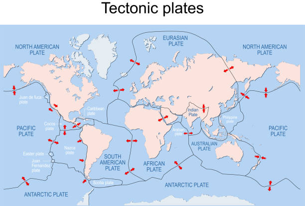
Map of Earth's principal tectonic plates. Earth's lithosphere. Major and minor plates. arrows indicate direction of movement at plate boundaries. Vector illustration
Tectonic plate earth map. Continental ocean pacific, volcano lithosphere geography plates.
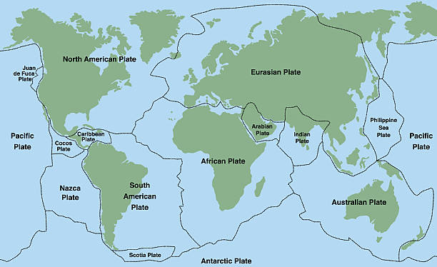
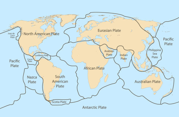
Plate tectonics - world map with major an minor plates. Vector illustration.

Convergent plate boundary created by two continental plates that slide towards each other. Digital illustration.
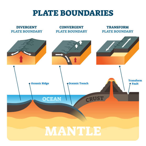
Plate boundaries vector illustration. Labeled tectonic movement comparison. Scheme with divergent, convergent and transform. Side view structure explanation with oceanic ridge, trench and mantle fault
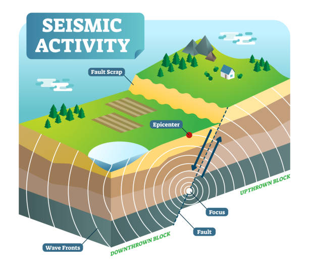
Seismic activity isometric vector illustration outdoor nature scene diagram with two moving plates and focus epicenter.
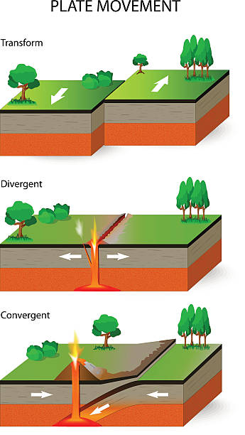
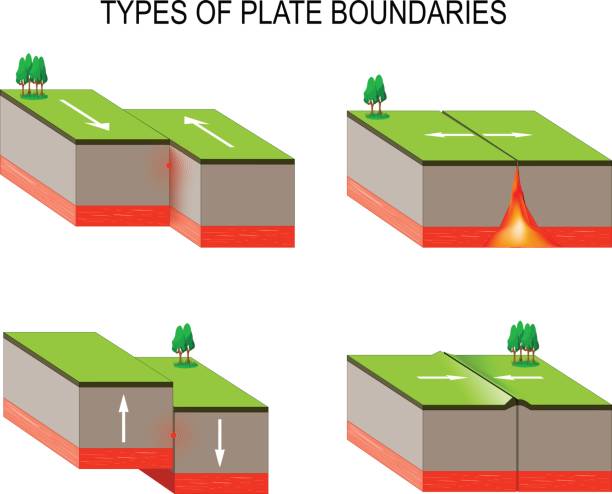
Plate movement. A cross section illustrating the main types of tectonic plate boundaries. convergent, divergent, and transform

World Map Showing Tectonic Plates Boundaries illustration
Two tectonic convergent plates boundaries move toward one another and collide.
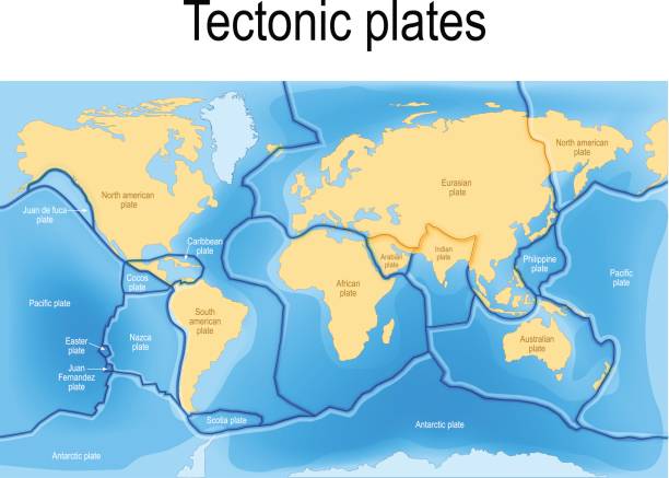
tectonic plates. World map with major an minor plates. Vector illustration.

Vector Illustration of Geological Faults and Volcano.

"Vector image of the boundaries of the tectonic plates in the Earths crust, responsible for earthquakes and volcanoes."
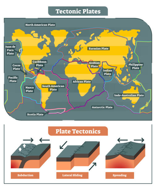
Tectonic Plates world map vector diagram and tectonic movement illustrations showing subduction, lateral sliding and spreading process.
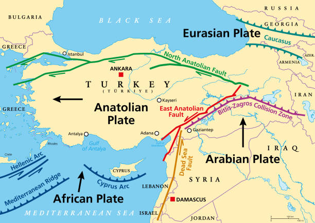
Anatolian Plate tectonics map. Most of the country of Turkey is located on this continental tectonic plate, that is separated from the Eurasian and Arabian Plate by the North and East Anatolian Fault.
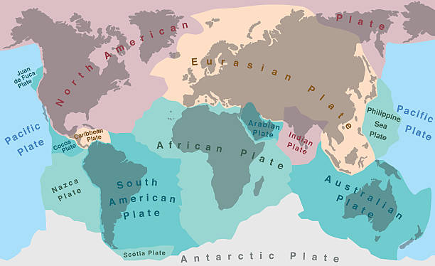
Tectonic plates of planet earth - map with names of major an minor plates.

Three types of tectonic boundaries illustration

Two tectonic divergent plates boundaries that are moving away from each other.

Plate tectonics- SPANISH TEXT! - planet earth with major an minor plates - vector illustration.

Ridge push, slab pull or trench suction labeled scheme vector illustration. Educational geography graphic with natural earth geological process. Continental drift, volcano eruption or seismic activity

Continental drift chronological movement, historical timeline with earth continents: Pangaea, Laurasia, Gondwana. Vector illustration world map.
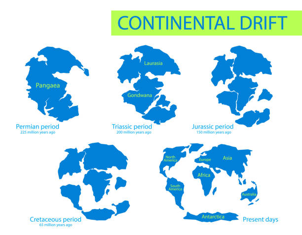

Plate tectonics. Earth's lithosphere. Scientific theory. Illustration shows Boundaries of Major (main) and minor plates. Continental drift.

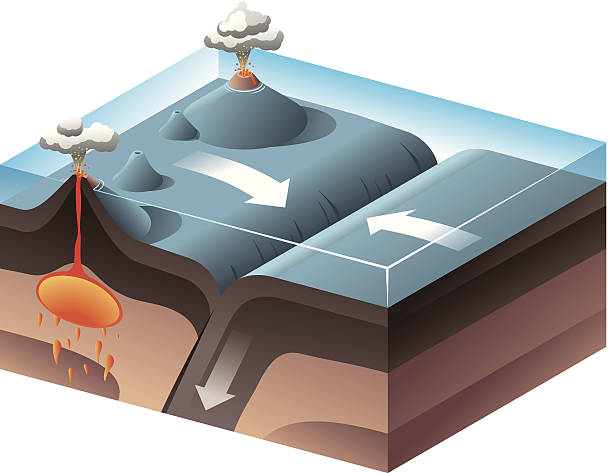
Vector illustration of Tectonic Plates - Subduction zone.

Hand-drawn vector drawing of a Plate Tectonics Diagram for converging Plates, Mountain Forming. Black-and-White sketch on a transparent background (.eps-file). Included files are EPS (v10) and Hi-Res JPG.

World Map Showing Tectonic Plates Boundaries illustration

Types of tectonic plate boundaries illustration

Plate tectonics map. major an minor plates. Vector illustration.

Seismic activity diagram. Vector isometric Earth crust compression, shear and tension stresses. Earthquake natural disasters concept for educational poster, scientific infographic, presentation.

Four types of mountains vector illustration. Labeled formation model explanation with folded, upwarped, fault block and volcanic examples. Geology science and study 3D material with hills descriptions


Isolated earth plates tectonic illustration

Tectonic plate. Earth's lithosphere. scientific theory. world map with major an minor plates. Vector illustration.

Lithosphere vector illustration. Labeled educational earth outer shell scheme. Explanation cross section diagram with asthenosphere, mantle and core structure. Detailed world parts explanation graphic

Map of tectonic plates and boundaries illustration

World plate tectonics vector map

plate boundary earthquake - isometric projection
tectonic plate interactions. Types of plate boundaries. Transform boundary occurs where two plates slide against each other in a shear movement. This movement is felt as an earthquake.
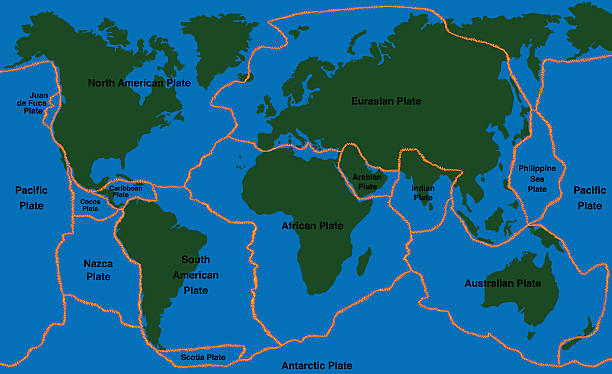
Plate tectonics - world map with fault lines of major an minor plates. Vector illustration.
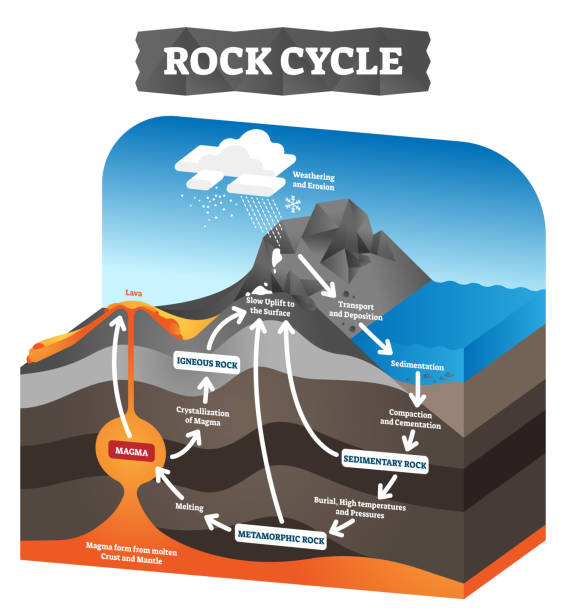
Rock cycle vector illustration. Educational labeled geology process scheme. Diagram with sedimentary, metamorphic and igneous formation. Pressure force impact on tectonic plates. Ground erosion layers

Tectonic plates unlabeled - world map with fault lines of major an minor plates.

A cross section illustrating the main types of tectonic plate boundaries convergent, divergent, or transform Earthquakes, volcanic activity, mountain-building, and oceanic trench formation occur along these plate boundaries

Richter earthquake magnitude scale. Vector diagram

Plate boundaries vector illustration. Labeled tectonic movement comparison. Scheme with divergent, convergent and transform. Side view structure explanation with oceanic ridge, trench and mantle fault

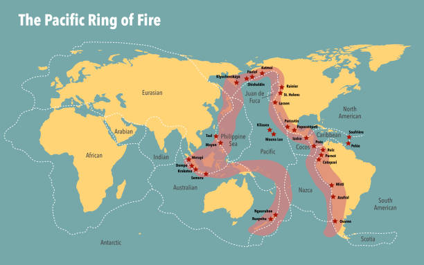
Map of the pacific ring of fire including the tectonic plates

Mediterranean Basin, Middle East and North Africa, tectonic map. The plate movements between the continents Eurasia, Africa and Asia causing earthquakes, volcanic eruptions and drifting landmasses.

Tsunami is a series of huge waves. It washes against the coast several times with great speed and force. Tsunamis generated by submarine earthquakes travel at subsonic speed across the ocean surface.

Seismogram of the earthquake. Seismic activity record. Vector illustration.

Isometric of volcano in cross section infographic. Structure include magma chamber, gases cone, vent and crater lava bomb ash. Section of the Earth crust.
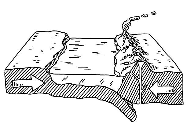
Hand-drawn vector drawing of a Plate Tectonics Diagram for converging Plates, Deep Sea Rift and Volcanoes. Black-and-White sketch on a transparent background (.eps-file). Included files are EPS (v10) and Hi-Res JPG.

https://dl.dropboxusercontent.com/u/488872/maps-lghtbx.jpg

Tectonic plates world map collection illustration

Earthquake magnitude levels vector illustration diagram, Richter scale seismic activity diagram with shaking intensity, from moving furniture to crashing buildings.

Earthquake. seismic activity: Seismic waves, fault, focus and epicenter earthquake

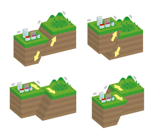

Plate tectonics on the planet Earth. Pangaea. Continental drift. Supercontinent at 250 Ma. Era of the dinosaurs. Jurassic period. Mesozoic. Hand drawn sketch for typography. Vintage engraving style

Map of the San Andreas fault in California

The ocean current world map with names illustration

Next