World Maps Labeled Silhouette stock illustrations
Browse 50+ world maps labeled silhouette stock illustrations and vector graphics available royalty-free, or start a new search to explore more great stock images and vector art.
Most popular
Hight detailed divided and labeled world map.

Hight detailed divided and labeled world map.

Hight detailed divided and labeled world map with navigation icons.
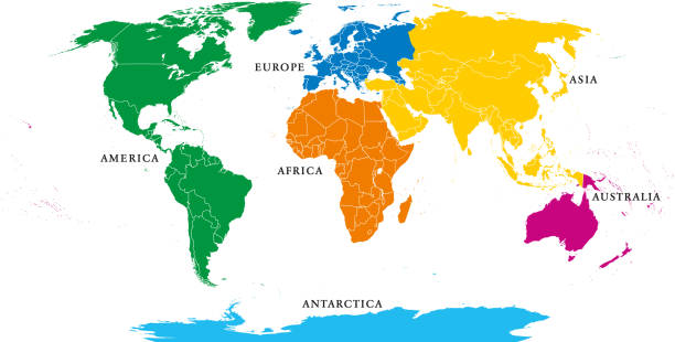
Six continents, political world map, with borders. Africa, America, Antarctica, Asia, Australia and Europe. Robinson projection. English labeling. Isolated illustration on white background. Vector.
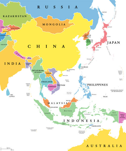
East Asia, single states, political map. All countries in different colors, with national borders, labeled with English country names. Eastern subregion of the Asian continent. Illustration. Vector.

Six continents world, political map. America, Africa, Antarctica, Asia, Australia and Europe, with shorelines and borders. Robinson projection. English labeling. Isolated on white background. Vector.
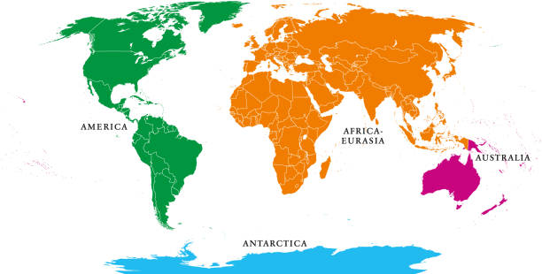
Four continents. World map with national borders. America, Africa-Eurasia, Australia and Antarctica. Political map under Robinson projection. English labeling. Isolated on white background. Vector.

Five continents, political world map, with borders. Africa, America, Antarctica, Asia, Australia and Europe. Robinson projection. English labeling. Isolated illustration on white background. Vector.

Four continents world map. America, Africa-Eurasia, Australia and Antarctica. Political map with shorelines and borders. Robinson projection. English labeling. Isolated on white background. Vector.

Political map of Africa. Blue colored land with country name labels on white background. Ortographic projection. Vector illustration

Political map of World with country names and capital cities. Gray vector map.

Five continents world, political map. Africa, America, Antarctica, Australia and Eurasia, with shorelines and borders. Robinson projection. English labeling. Isolated on white background. Vector.

European Union countries. English labeling. Political map with borders and country names. 28 EU members, colored in light blue. Political and economic union in Europe. Illustration over white. Vector.

Hight detailed divided and labeled world map with navigation icons.

World map referenced from:

Europe regions, political map, with single countries. Northern, Western, Southeastern, Eastern, Central, Southern and Southwestern Europe in different colors. English labeling. Illustration. Vector.

Hight detailed divided and labeled world map with navigation icons.

Regions of Europe, political map, with single countries and English labeling. Northern, Western, Southeastern, Eastern, Central, Southern, Southwestern Europe in different colors. Illustration. Vector

Eastern Europe detailed editable map with regions cities and towns, roads and railways. Vector EPS-10 file

Simplified schematic map of South America. Vector political map in high contrast of black and white.

Simplified schematic map of North America. Vector political map in high contrast of black and white.

Simplified schematic map of Europe. Vector political map in high contrast of black and white.

Simplified schematic map of Asia. Vector political map in high contrast of black and white.

Set of six world continent maps in a row - North America, South America, Africa, Europe, Asia and Australia. Flat vector map with country name labels

Set of six world continent maps in a row - North America, South America, Africa, Europe, Asia and Australia. Flat grey vector map with country name labels


Political map of Asia. Thin black outline map with country name labels on white background. Ortographic projection. Vector illustration

Simplified schematic map of Africa. Vector political map in high contrast of black and white.

Bosnia and Hercegovina marked by blue in grey political map of Europe. Vector illustration.

Czechia marked by blue in grey political map of Europe. Vector illustration.

European Union countries. English labeling. Political map with borders and country names. 28 EU members, colored in light blue. Political and economic union in Europe. Illustration over white. Vector.

Abstract mountain silhouette with black outline compass for anventure and traveling logo

Political map of Africa. Yellow colored land with country name labels on dark gray background. Ortographic projection. Vector illustration

Political map of North America. Blue colored land with country name labels on white background. Ortographic projection. Vector illustration

Political map of Asia. Yellow colored land with country name labels on dark gray background. Ortographic projection. Vector illustration

Political map of World with country names and capital cities. Grey vector map.

Political map of Europe. Blue colored land with country name labels on white background. Ortographic projection. Vector illustration

Political map of Europe. Yellow colored land with country name labels on dark gray background. Ortographic projection. Vector illustration


Simplified schematic map of Africa. Vector political map.

Simplified schematic map of Asia. Vector political map.

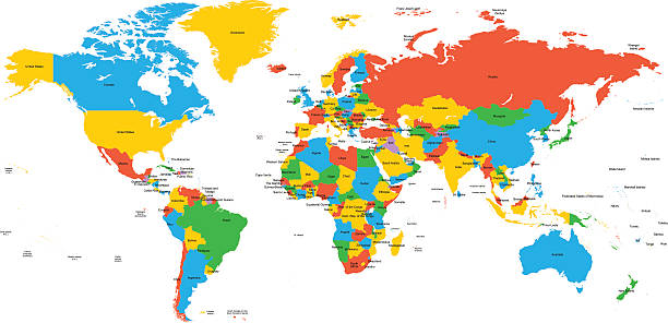
Colorful political map of World with country name labelling

Political map of Africa. Thin black outline map with country name labels on white background. Ortographic projection. Vector illustration

Political map of South America. Yellow colored land with country name labels on dark gray background. Ortographic projection. Vector illustration

Political map of South America. Blue colored land with country name labels on white background. Ortographic projection. Vector illustration

Political map of Europe. Thin black outline map with country name labels on white background. Ortographic projection. Vector illustration

Political map of South America. Thin black outline map with country name labels on white background. Ortographic projection. Vector illustration

Political map of North America. Thin black outline map with country name labels on white background. Ortographic projection. Vector illustration

Colorful political map of World with country name labelling

Russia marked by blue in grey political map of Europe. Vector illustration.

Regions of Europe, political map, with single countries. Northern, Western, Southeastern, Eastern, Central, Southern and Southwestern Europe in different colors. English labeling. Illustration. Vector

Ireland marked by blue in grey political map of Europe. Vector illustration.

Hight detailed divided and labeled world map.

High detailed China map with flag and labelings. Editable gray political map of China with region borders, neighboring countries and national waving flag vector illustration

Political map of North America. Yellow colored land with country name labels on dark gray background. Ortographic projection. Vector illustration

Political map of Asia. Blue colored land with country name labels on white background. Ortographic projection. Vector illustration

Hight detailed divided and labeled world map.

Hight detailed divided and labeled world map with navigation icons.