
Beersheba Pictures, Images and Stock Photos
Browse 740+ beersheba stock photos and images available, or search for be'er sheva or nazareth to find more great stock photos and pictures.
Aerial view on the Beer-Sheva street with crossroad, mall, fountain and palm grove

Be'er Sheva, Southern Israel.

View on crossroad in Beersheba

Panoramic view of Tel Beer Sheva archaeological site, believed to be the remains of the biblical town of Beersheba. Now a UNESCO world heritage site and national park. Southern Israel

BEER-SHEVA, ISRAEL- MAY 25, 2014: Fountain at night in Beer Sheva.

Old residential district in Beer Sheba at sunset in a winter

The 180 degree panoramic view on residential and commercial buildings Beer Sheva city at winter


The monument tank M60 on a pedestal in the center of the crossroad in Beer Sheba

BEER-SHEVA, ISRAEL- MAY 10, 2014: Fountain in the center of the city.

Turkish Mosque in Beer Sheba Israel

180 degree panoramic view on Beer Sheva city with commercial and residential buildings at winter


PALACE OF JUSTICE, BEER-SHEVA, ISRAEL- MAY 10, 2014: Palace of Justice in Beersheba, Israel

Beer Sheva, Israel - FEB 22, 2020: Aerial view on street with crossroad, mall, fountain and palm grove

Beer Sheba, Israel - May 12, 2016: old residential district with tall buildings in the background in Beersheba

180 degrees aerial panorama of Beer Sheba city with residential buildings
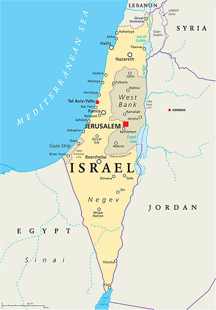
Israel political map with capital Jerusalem, national borders, important cities, rivers and lakes. English labeling and scaling. Illustration.

BEER-SHEBA, ISRAEL - feb, 24, 2018: View on the old and new residential buildings in Beersheba


Beer-Sheba, Israel - Apr 17, 2022: Wide panorama with three tall residential buildings in Beer-Sheba, Israel


Historical view of Beersheba and the surrounding area. Today it is the largest city in the Negev desert of southern Israel. The Biblical site of Beersheba is Tel Be'er Sheva, lying some 4 km distant from the modern city, which was established at the start of the 20th century by the Ottoman Turks. Wood engraving, published in 1862.
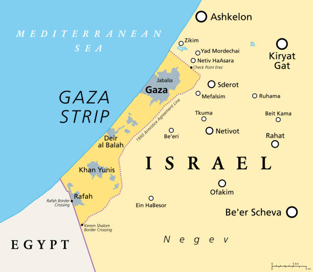
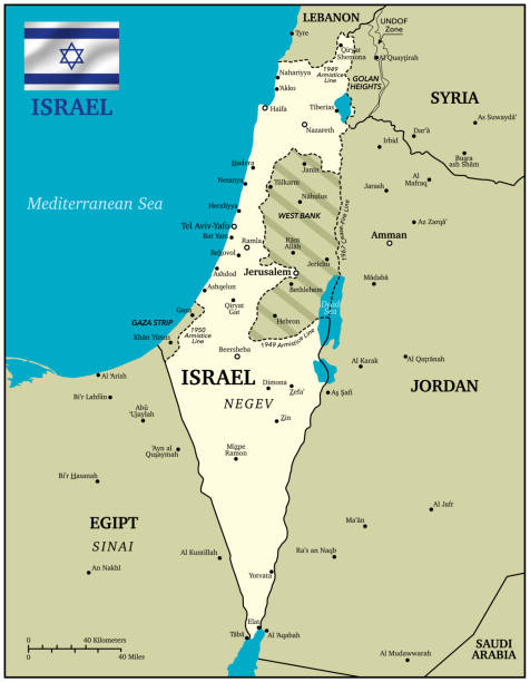
The Gaza Strip and surroundings, political map. Gaza is a self-governing Palestinian territory and narrow piece of land located on the coast of the Mediterranean Sea, bordered by Israel and Egypt.
Map of Israel - Vintage Vector illustration

BEER-SHEVA, ISRAEL- MAY 25, 2014: Soroka Medical Center, night.

From Harper's magazine - 1872

Far distance panorama of artificial lake lake and park in Beer Sheva

180 degree panorama of artificial lake lake and park in Beer Sheva
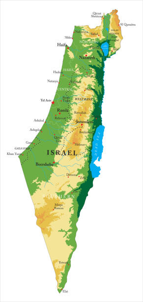
Highly detailed physical map of Israel,in vector format,with all the relief forms,regions and big cities.


3D map of Israel with topographic relief, borders. Detailed isometric physical map of the Israel-Palestine with Gaza strip, West Bank areas, big cities.

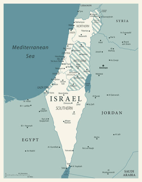
Part of the Southern District of Israel, political map, with the Gaza Strip, bottom half of West Bank, Dead Sea, and with borders and most important cities in this region. Illustration. Vector.
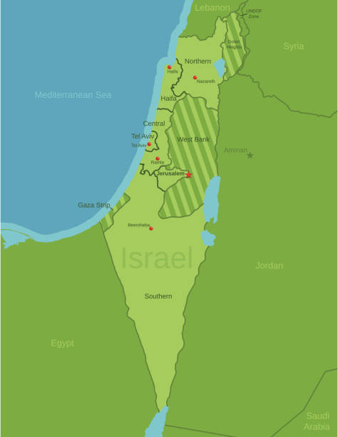
Vector maps of Israel with variable specification and icons

Map of Israel - Vintage Vector illustration

Middle East. Israel. Negev. Beersheba. 05/01/2013. This colorful image depicts Four-Horned altar to sacrifice Jewish. The biblical tel of Beer Sheba. Fifteen strata of settlement have been discovered at Tel Be'er Sheba, from Chalcolitic to the Early Arab perido. In 2005, Tel Be'er Sheva was inscribed as a UNESCO World Heritage Site.
Vector Illustration of a Drawning Hand Traced Map of Israel and Flag
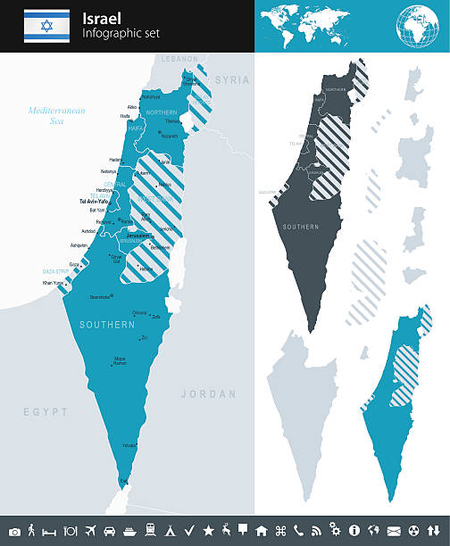
This file is a map highlighting Israel as well as it's districts and capital cities. This map also shows surrounding countries and capital cities if present. This map has text labels for the countries, districts, capital cities and major bodies of water. ZOOM IN on this highly detailed map, it is a great addition to the collection. This file will work well for your print or web based project. This file is layered and grouped (labeled in ai v10 file), making it a very easy file to work with. This download contains an editable ai v10 and eps file, as well as a large JPG file.

Israel - Vector Map

View on Beer Sheba city with commercial and residential buildings from the big height

Scenic view of sand, hills and rocks in Negev Desert in Mitzpe Ramon, Israel

Scenic view of sand, hills and rocks in Negev Desert in Mitzpe Ramon, Israel

3D Illustration of a waving Israel city flag of Beersheba


Beer Sheba, Israel - Feb, 24, 2018: French pilgrims pray in the open air

Mitzpe Ramon, Israel - 22 november, 2016: People on observation terrae at the crater Ramon at Negev desert, Israel


BEER-SHEVA, ISRAEL- MAY 25, 2014: City center at night.

Beer Sheva, Israel - Aug 29, 2021: Wide panorama of old city districts with new tall buildings


Illustration of a Abrahams Well at Beersheba

Panorama of tall buildings in Beer-Sheba behind the flowering field

BEER-SHEBA, ISRAEL - JUN 07, 2019: Rolls Royce Corniche at motorshow in Beer-Sheba

Panorama of Ashalim Power Station. Power station Aschalim. The solar power station is built in the Negev desert south of the city of Beer-Sheva, Israel

BEER-SHEVA, ISRAEL- MAY 25, 2014: Central entry to Soroka Medical Center, night.

3D Render of a Map of Israel with Straight Pins at the Position of important Cities. Vintage Color Style. Very high resolution available!

Israel - Retro Vector Map

BEER-SHEVA, ISRAEL- MAY 25, 2014: Central street name Ruger, Ben-Gurion University of the evening.

View of Tel Beer Sheva archaeological site, believed to be the remains of the biblical town of Beersheba. Now a UNESCO world heritage site and national park. Southern Israel

BEER-SHEBA, ISRAEL - MAR 15, 2020: View from the street to the Grand Mall in Beer-Sheva
Next