
Civil Map Pictures, Images and Stock Photos
Browse 830+ civil map stock photos and images available, or start a new search to explore more stock photos and images.
Most popular
Administrative map of Germany with regions. Vector illustration isolated on white background

Map of Port Hudson and it's Defences

The Encounter of Tanks on the Map of Ukraine. 3d Rendering http://www.lib.utexas.edu/maps/world.html

Map of Gettysburg and it's Vecinity
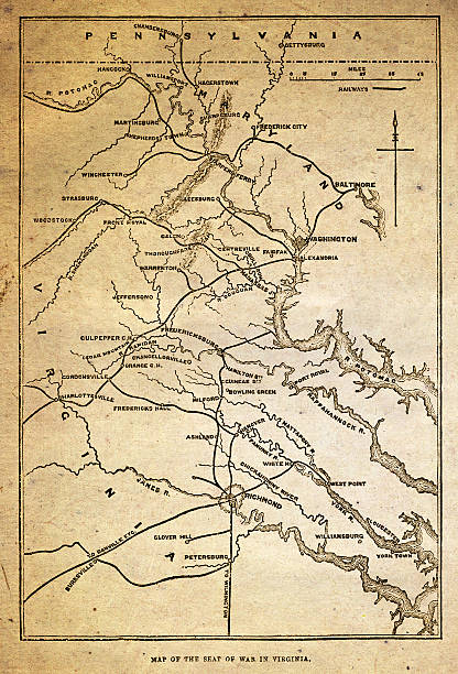
A map of the 'seat' of American civil war in Virginia from ”The Leisure Hour”, a British “Journal of Instruction and Recreation”. This edition was published in May 1864. Virginia was one of the Confederate States during the Civil War of 1861-65.

Burning map of United States of America Constitution with "We the People" caption. Presidential election political crisis, inauguration, civil war, breakup conflict, concept vector illustration.

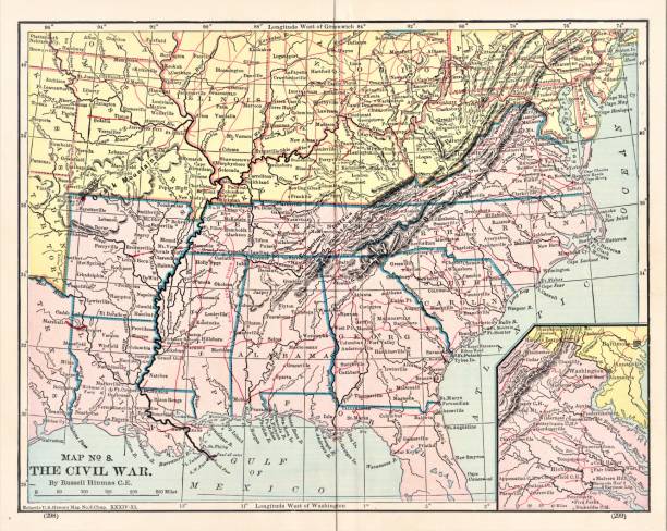
Map of the United States Civil War military campaigns. Illustration published in The New Eclectic History of the United States by M. E. Thalheimer (American Book Company; New York, Cincinnati, and Chicago) in 1881 and 1890. Copyright expired; artwork is in Public Domain.

Map of Civil War Map of Operations in the West, United States History. Illustration published in First Lessons in Our Country’s History by William Swinton, A.M. (Ivison, Blakeman, Taylor, & Company, New York and Chicago) in 1872.

Map of the defenses and approaches of Harper's Ferry during the American Civil War - Scanned 1887 Map

Chattanooga and it's Defences19th Century Engraving

military history


Realistic 3d Detailed Airplane and Seat Map Top View Concept Card for Passenger Business and Economy Classes. Vector illustration

NEW YORK - DEC 12, 2015 - Map of battles of Winchester, Fishers Hill and Cedar Creek, 1864
Antique illustration

Kashmir crisis. Kashmir map with Pakistan and India - vector illustration

American Civil War map of Atlanta. Georgia, USA. Illustration engraving published 1895. Original edition is from my own archives. Copyright has expired and is in Public Domain.

Antique illustration


Colombia's map with tricolor flag colors, hand holding a vote in hand drawn style ready to suffrage during Colombian elections.

Map of Confederate Army Raids in Maryland. Illustration engraving published 1895. Original edition is from my own archives. Copyright has expired and is in Public Domain.

The Encounter of Tanks on the Map of Ukraine. 3d Rendering http://www.lib.utexas.edu/maps/world.html
Antique illustration

Antique illustration

From Barness Primary History of the United States published in 1885

Hot Zones Marked on the Map of Ukraine. 3d Rendering http://www.lib.utexas.edu/maps/world.html

Map of the Spanish civil war and occupied territories between 1936 and 1939

Antique illustration


Total station or electronic distance measurement for building or construction site

Map of Civil War Map of Operations in the West, United States History. Illustration published in First Lessons in Our Country’s History by William Swinton, A.M. (Ivison, Blakeman, Taylor, & Company, New York and Chicago) in 1872.

Antique illustration


Cropped view of professional interior designer working at home office in architectural agency, checking blueprint, looking at remodeling plan and documents while paper lying on desk

Antique illustration

3d isometric three-dimensional modern city view. City with roads, skyscrapers, civil buildings and transport

Lgbt flag in contour of Rio Grande do Sul with light grey background. Brazilian state. South of Brazil.

Map of Charleston Harbor, South Carolina, during the United States Civil War. The first battle in the harbor was 1963. Illustration published in The New Eclectic History of the United States by M. E. Thalheimer (American Book Company; New York, Cincinnati, and Chicago) in 1881 and 1890. Copyright expired; artwork is in Public Domain.

International Day of Democracy. September 15. Holiday concept. Template for background, banner, card, poster with text inscription. Vector EPS10 illustration


Map with the Union and Confederate states and the status of slavery during American Civil war


Antique illustration

Antique illustration

Top view banner of diverse group of civil engineer and client working together on architectural project, reviewing construction plan and building blueprint at meeting table. Prudent

Construction business concept with civil engineer and cityscape background


Antique illustration

An engineer who uses a tablet and works on a construction site. Medium shot. Civil engineer. Raw video ready for further processing in video production.

Black History Month, African American History Background Cover. Abstract Celebration of Black History Month with Colorful Paint

Civil officers with new road contruction site surveys, sport focus

Engraving of the Map of the Battle of Gettysburgs, Pennsylvania, July 3, 1863 Civil War Engraving from "Famous Leaders and Battle Scenes of the Civil War," Published in 1864. Original edition from my own archives. Copyright has expired on this artwork. Digitally restored.

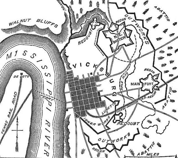
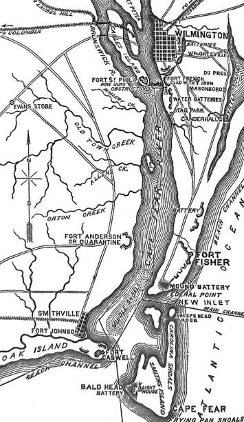
Vintage engraving of a American Civil War, Map of Defenses of River Mississippi

Antique illustration

Antique illustration

Civil engineer using telescope at survey.

Next