
Eyjafjallajokull Glacier Pictures, Images and Stock Photos
Browse 1,400+ eyjafjallajokull glacier stock photos and images available, or search for iceland volcano or krakatau to find more great stock photos and pictures.
Most popular
Volcano eruption in Eyjafjallajokull in Iceland
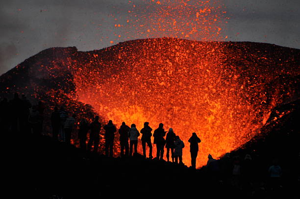
The sillouette of group of adventurers witnessing the eruption of volcano Eyjafjallajökull right up close, literally meters away from the molten lava, very brave of them. Certainly a once in a life time experience!


Eyjafjallajökull volcano eruption in April 2010 in South Iceland.


Houses at the foot of the eyjafjallajokull volcano at sunset in Iceland

The 2010 eruptions of Eyjafjallajokull were volcanic events at Eyjafjallajokull in Iceland which, although relatively small for volcanic eruptions, caused enormous disruption to air travel across western and northern Europe over an initial period of six days in April 2010. Additional localised disruption continued into May 2010. The eruption was declared officially over in October 2010, when snow on the glacier did not melt. From 14–20 April, ash from the volcanic eruption covered large areas of Northern Europe. About 20 countries closed their airspace to commercial jet traffic and it affected approximately 10 million travellers.


Hiking the Laugavegur Trail in the Landmannalaugar region of Iceland.
Gígjökull, Iceland - February 26, 2012: Black ash lagoon at base of Gígjökull outlet glacier from Eyjafjallajokull ice cap

Man walking close to Eyjafjallajokull glacier

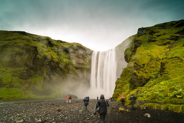
Skogafoss Waterfall - Iceland


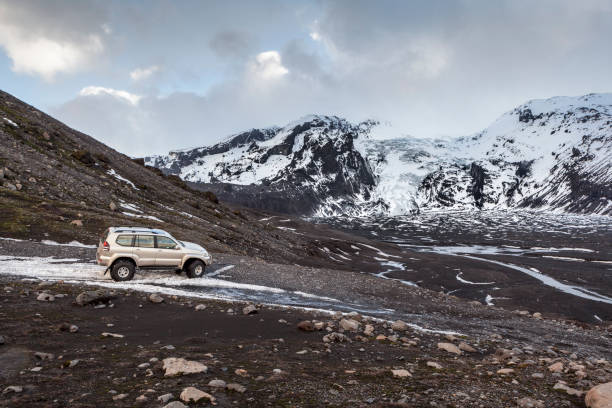
Southern Glaciers Iceland Frozen Volcanic Gravel Field in Winter. Icelandic snowcapped Glacier Mountain Range close to Hvannadalshnúkur - Svínafell Panorama under sunny blue skyscape. Volcanic rocks, glacier and gravel field in the foreground. Canon R5 Stitched Panorama. Hvannadalshnúkur - Svínafell, Southern Iceland in Winter, Nordic Countries, Northern Europe.

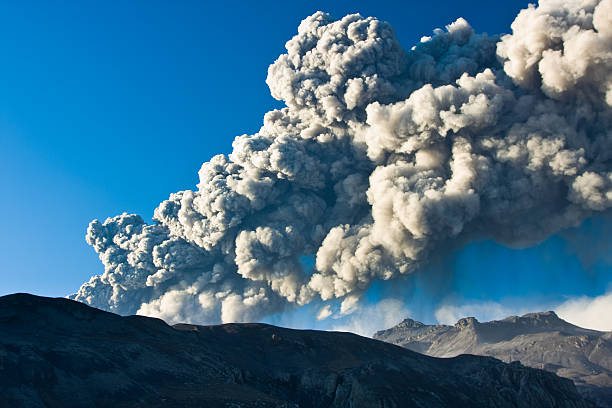
Ash cloud from the Eyjafjallajokull eruption in Iceland towering over a nearby farm

Eyjafjallajökull Volcano in Dormant state landscape with glacier above Katla Volcano Southern Iceland

Lonely Icelandic farm under the mountains at a good sunny day with blue sky and white clouds

A cloudy mountain range next to the Eyjafjallajökull Volcano in Iceland.

The dramatically beautiful and surreal landscapes of Throsmork in the Highlands of Iceland at southern end of the famous Laugavegur hiking trail.

A herd of Icelandic horses with Eyjafjallajökull volcano in the background.

Phot of the amazing Eyjafjallajokull glacier in Iceland during winter

The 2010 eruptions of Eyjafjallajökull were volcanic events at Eyjafjallajökull in Iceland which, although relatively small for volcanic eruptions, caused enormous disruption to air travel across western and northern Europe over an initial period of six days in April 2010. Additional localised disruption continued into May 2010. The eruption was declared officially over in October 2010, when snow on the glacier did not melt.

Eyjafjallajokull is a volcano completely covered by an ice cap. The volcano has erupted relatively frequently since the last glacial period, most recently in 2010.

Hiking on Fimmvorduhals, looking through a valley with moss covered mountain sides, Thorsmork visible in the distant.

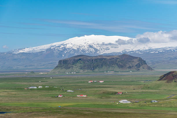
Road leading towards Thorvaldseyri farm, the famous farmstead located right in front of Eyjafjallajökull glacier and volcano with its snow-capped summit, Route 1 / Ring Road, Southern Region, Iceland

The 2010 eruptions of Eyjafjallajökull were volcanic events at Eyjafjallajökull in Iceland which, although relatively small for volcanic eruptions, caused enormous disruption to air travel across western and northern Europe over an initial period of six days in April 2010. Additional localised disruption continued into May 2010. The eruption was declared officially over in October 2010, when snow on the glacier did not melt.

Morning hike on a new born, active volcano on Fimmvörðuháls, Iceland

Ringstraße mit Blick auf den Eyjafjallajökull-Gletscher im Süden der Insel von Island, Europa, Nordeuropa

large Icelandic glacier and green grass landscape

Eyjafjallajökull volcano eruption in April 2010 in South Iceland.


Seljalandsfoss is a waterfall in Iceland. Seljalandsfoss is a waterfall located in the South Region of Iceland right by Route 1. The waterfall drops 60 m (197 ft) and is part of the Seljalands River that has its origin in the volcano glacier Eyjafjallajökull. Visitors can walk behind the falls into a small cave.

The 2010 eruptions of Eyjafjallajokull were volcanic events at Eyjafjallajokull in Iceland which, although relatively small for volcanic eruptions, caused enormous disruption to air travel across western and northern Europe over an initial period of six days in April 2010. Additional localised disruption continued into May 2010. The eruption was declared officially over in October 2010, when snow on the glacier did not melt. From 14–20 April, ash from the volcanic eruption covered large areas of Northern Europe. About 20 countries closed their airspace to commercial jet traffic and it affected approximately 10 million travellers.


fimmvörduhals hiking path along the skoga river and between the two famous icelandic glaciers myrdalsjökull and eyjafjallajökull, southern iceland; view to eyjafjallajökull volcanic glacier

Eyjafjallajökull is one of the smaller ice caps of Iceland, situated to the north of Skógar and to the west of Mýrdalsjökull. The ice cap covers the caldera of a volcano with a summit elevation of 1,651 metres. The volcano has erupted relatively frequently since the last glacial period, most recently in 2010.
A set of Icelandic themed icons. See below for more travel and other country icon sets. If you can't find the country or city you require message me as I take requests!

Volcano eruption in Eyjafjallajokull in Iceland


Langidalur camping site in Thorsmork with view on Godaland and Eyjafjallajokull glacier volcano and river Krossa. Highlands of Iceland, end of the Laugavegur hiking trail. Summer Golden hour

"Detailed vector map of Iceland with administrative divisions. File was created on October 19, 2012. The colors in the .eps-file are ready for print (CMYK). Included files: EPS (v8) and Hi-Res JPG (5600aa aaa 3761 px)."

View to a valley next to the Eyjafjallajokull volcano in Iceland from a helicopter cockpit

The 2010 eruptions of Eyjafjallajokull were volcanic events at Eyjafjallajokull in Iceland which, although relatively small for volcanic eruptions, caused enormous disruption to air travel across western and northern Europe over an initial period of six days in April 2010. Additional localised disruption continued into May 2010. The eruption was declared officially over in October 2010, when snow on the glacier did not melt. From 14–20 April, ash from the volcanic eruption covered large areas of Northern Europe. About 20 countries closed their airspace to commercial jet traffic and it affected approximately 10 million travellers.


Walls of a moulin (or glacier mill) in Myrdalsjökull in Iceland, covered in the ashes of the 2010 eruption of nearby Eyjafjallajökull. Moulins (from the French word for mill) are circular, vertical shafts, formed by running water, and are a common predecessor to glacial ice caves.

The ash cloud being blown out by the volcanic eruption at Eyjafjallajökull in Iceland.The ash cloud being blown out by the volcanic eruption at Eyjafjallajökull in Iceland.

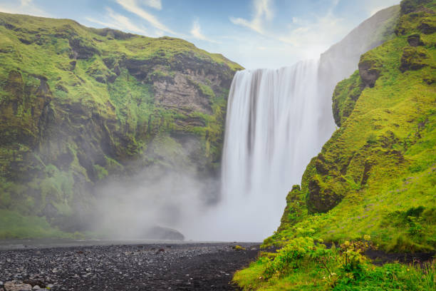
The spectacular Skogafoss Waterfall. Long Exposure with Motion Blured Water of Skoga River. The Skógafoss is one of the biggest waterfalls in the country with a width of 25 metres - 82 feet and a drop of 60 m - 200 ft. Skógafoss, Southern Iceland, South Region (Sudurland), Iceland, Nordic Countries, Europe

The beautiful unique aerial view landscape of Thorsmork in highland of Iceland.

Empty Route 1 Country National Road, famous icelandic Ring Road Route 1 between the cities of Selfoss and Vik, along the north atlantic ocean and green icelandic mountains in summer. Aerial Drone Point of View. South Central Iceland, Selfoss - Vik, Iceland, Nordic Countries, Northern Europe.
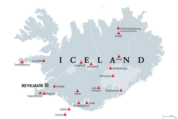
Volcanoes of Iceland that erupted since human settlement, political map. Eighteen volcanoes shown on gray map of Iceland, with glaciers and regions. Isolated illustration on white background. Vector.

thorsmork national park in iceland - green mountains glacier tongue wit hwhite clouds and blue sky

Icelandic snowcapped Glacier Mountain Range close to Hvannadalshnúkur - Svínafell Panorama under sunny blue skyscape. Volcanic rocks, glacier and gravel field in the foreground. Canon R5 Panorama. Hvannadalshnúkur - Svínafell, Southern Iceland in Winter, Nordic Countries, Northern Europe.

Eyjafjallajokull glacier in Iceland.


Next