
Hattiesburg Mississippi Pictures, Images and Stock Photos
Browse 190+ hattiesburg mississippi stock photos and images available, or search for jackson mississippi or twin falls idaho to find more great stock photos and pictures.
Hattiesburg is a city in Mississippi, bisected by the county line between Forrest and Lamar counties
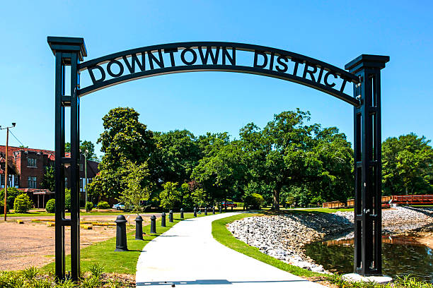
Hattiesburg, MS, USA - June 6th, 2015: Downtown District overhead sign in the regenerated area of Hattiesburg, Mississippi

Hattiesburg, Mississippi: 1910 Neoclassical Revival

Hattiesburg, MS, USA - June 6th, 2015: The Forest County Courthouse and to the right, the Confederate war memorial, the masonic temple and Christian church, all in the historic distric of Hattiesburg, Mississippi

A front view of the Administration Building of the University of Southern Mississipi, Hattiesburg, MississippiThe Administration Building at the University of Southern Mississippi in Hattiesburg, Mississippi

Hattiesburg is a city in Mississippi, bisected by the county line between Forrest and Lamar counties
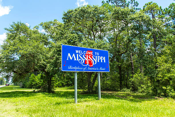
Red, white, and blue sign to welcome travelers to Mississippi - Birthplace of America's Music

Hattiesburg, MS, USA - June 6th, 2015: Hattiesburg Mississippi Amtrak railway station platform overhead curved metal canopy

Red, white, and blue sign to welcome travelers to Mississippi - Birthplace of America's Music

Hattiesburg, MS, USA - June 6th, 2015: The Forest County Courthouse and Confederate war memorial in downtown Hattiesburg, Mississippi

The Administration Building at the University of Southern Mississippi in Hattiesburg, Mississippi

Hattiesburg, MS, USA - June 6th, 2015: Hattiesburg Mississippi Amtrak railway station platform and sign with the freight yard in the background full of oil tanker wagons

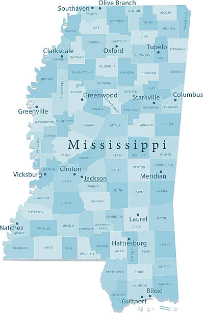
Mississippi, MS, political map, with capital Jackson, important cities, rivers and lakes. State in the Southeastern region of the United States, nicknamed The Magnolia State and The Hospitality State.

waterfall on Gordon's Creek in Hattiesburg, Mississippi

Hattiesburg, MS, USA - June 6th, 2015: Hattiesburg Mississippi Amtrak railway station platform and overhead canopy

Hattiesburg, MS / USA - September 17, 2020: Iconic Administration Building of the University of Southern Mississippi

Hattiesburg, MS, USA - June 6th, 2015: Hattiesburg Mississippi Amtrak railway station platform

Hattiesburg, MS / USA - September 17, 2020: Iconic Administration Building of the University of Southern Mississippi


Hattiesburg, MS, USA - June 6th, 2015: North Main Street Historic District shield shaped banner sign in Hattiesburg Mississippi

Hattiesburg, MS / USA - September 17, 2020: Confederate Statue next to Forrest County Court house
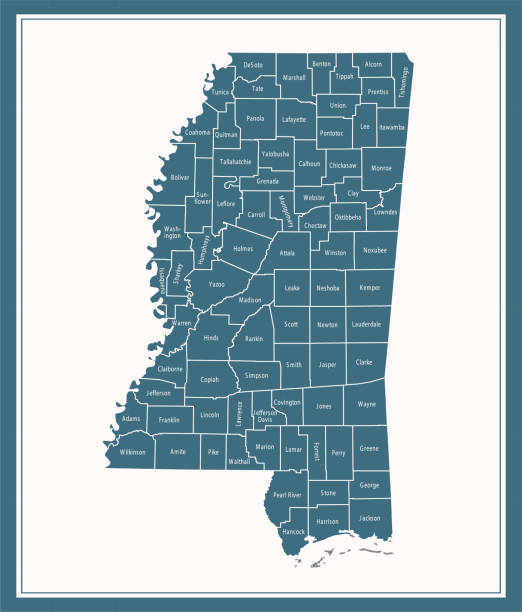
Downloadable county map of Mississippi state of United States of America. The map is accurately prepared by a map expert.

Hattiesburg, MS / USA - September 17, 2020: City Hall in Hattiesburg, Mississippi

A railroad track passing under a highway near Hattiesburg, Mississiippi. Stunning example of where the old meets the new.
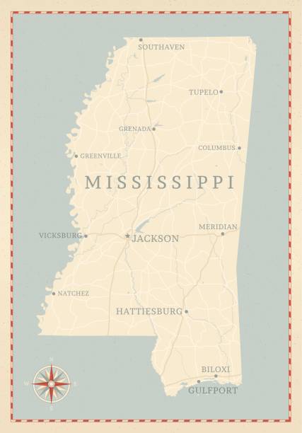
A vintage-style map of Mississippi with freeways, highways and major cities. Shoreline, lakes and rivers are very detailed. Includes an EPS and JPG of the map without roads and cities. Texture, compass, cities, etc. are on separate layers for easy removal or changes.
Detailed vector map of Mississippi with administrative divisions. File was created on June 5, 2013. The colors in the .eps-file are ready for print (CMYK). Included files: EPS (v8) and Hi-Res JPG (3811 × 5600 px).

Detailed map of Mississippi state,in vector format,with county borders and major cities.

Highly detailed vector map of Mississippi, United States. Source data courtesy of NGDC (database: World Data Bank II), NASA (reference images: Blue Marble) and National Atlas (database: county boundaries). The source data is in the public domain. Data updated and improved. File was created on May 29, 2013. The colors in the .eps-file are ready for print (CMYK). Included files: EPS (v8) and Hi-Res JPG (5600 × 5600 px).


Green green grass of home in Hattiesburg, Mississippi.

What a beautiful pink rose found in Hattiesburg, Mississippi. It sure is an amazing flower.
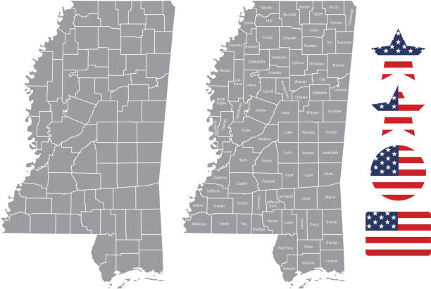
The maps are accurately prepared by a GIS and remote sensing expert.

State line sign welcoming travellers to Mississippi. Copy space over road to the left of the sign.


Red roses and petals in a garden in Hattiesburg, Mississippi.

Hattiesburg, MS, USA - June 6th, 2015: Street signs at the intersection of N Main Street and Melrose Street in Hattiesburg, Mississippi

Hattiesburg, MS, USA - June 6th, 2015: White painted residential home with rocking chairs on the front porch in Hattiesburg Mississippi

"Vector illustration of map of Mississippi with major roads, rivers and lakes."


Radar rainfall estimates depicting very heavy rain across Mississippi near and around Hattiesburg.

3D Render of a Map of Mississippi with Straight Pins at the Position of important Cities. Vintage Color Style. Very high resolution available! All source data is in the public domain. http://www.naturalearthdata.com/about/terms-of-use/ Made with Natural Earth: Internal Administrative Boundaries, Populated Places http://www.naturalearthdata.com/downloads/10m-cultural-vectors/
The map is accurately prepared by a map expert.

Hattiesburg, MS - June 12, 2022: Entrance sign to the University of Southern Mississippi

Hattiesburg, MS, USA - June 6th, 2015: The Dollar Box showroom multi- store complex on Main Street in downtown Hattiesburg, Mississippi

A curved road in downtown Hattiesburg, Mississippi in the evening

Hattiesburg, MS, USA - June 6th, 2015: The Masonic Temple building on Main Street on the historic district of Hattiesburg, Mississippi with the state flag to the left which includes the confederate flag symbol

Vector Illustration of a Road Map of Mississippi State, USA. All source data is in the public domain. U.S. Geological Survey, US Topo Used Layers: USGS The National Map: National Hydrography Dataset (NHD) USGS The National Map: National Transportation Dataset (NTD)

Radar rainfall estimates depicting very heavy rain across Mississippi near and around Hattiesburg.

A Mississippi road sign concept with an original sunset background.


Mississippi, MS, gray political map with capital Jackson, and large and important cities. State in the Southeastern region of the United States, nicknamed The Magnolia State and The Hospitality State.

Flag of american state of Mississippi, region of the United States, waving at wind

A historic Coca Cola warehouse building in the evening in Hattiesburg, Mississippi

Hattiesburg, MS / USA - September 17, 2020: Forrest County Mississippi Circuit Court Building with confederate statue.

Train trellis found in Hattiesburg, Mississippi.

Hattiesburg, MS, USA - June 6th, 2015: Oil tanker and freight carriages at the Hattiesburg Mississippi Amtrak railway yard

Hattiesburg, MS, USA - June 6th, 2015: Closed for business with real estate signs stuck on the door, the old Insured Savings bank in Hattiesburg Mississippi

Vector Illustration of a City Street Map of Hattiesburg, Mississippi, USA. Scale 1:60,000. All source data is in the public domain. U.S. Geological Survey, US Topo Used Layers: USGS The National Map: National Hydrography Dataset (NHD) USGS The National Map: National Transportation Dataset (NTD)

Printable map of Mississippi state of United States of America. The map is accurately prepared by a map expert.

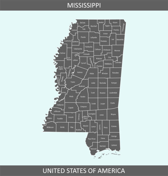
Highly detailed map of Mississippi county state of United States of America for web banner, mobile, smartphone, iPhone, iPad applications and educational use. The map is accurately prepared by a map expert.
Next