Israel From Space Pictures, Images and Stock Photos
Browse 80+ israel from space stock photos and images available, or search for earth from space or israel aerial to find more great stock photos and pictures.
Most popular
3D Render of a Topographic Map of Israel, Middle East. All source data is in the public domain. Color texture: Made with Natural Earth. http://www.naturalearthdata.com/downloads/10m-raster-data/10m-cross-blend-hypso/ Relief texture and Rivers: SRTM data courtesy of USGS. URL of source image: https://e4ftl01.cr.usgs.gov//MODV6_Dal_D/SRTM/SRTMGL1.003/2000.02.11/ Water texture: SRTM Water Body SWDB: https://dds.cr.usgs.gov/srtm/version2_1/SWBD/
"Iraq, Iran, Afghanistan, Pakistan, Israel, Syria, Jordan...Middle east from the space.(some images provided by NASA http://visibleearth.nasa.gov and http://grin.hq.nasa.gov)"

3D Render of a Topographic Map of the Middle East region including Syria and Iraq. All source data is in the public domain. Color texture and Rivers: Made with Natural Earth. http://www.naturalearthdata.com/downloads/10m-raster-data/10m-cross-blend-hypso/ http://www.naturalearthdata.com/downloads/10m-physical-vectors/ Relief texture: SRTM data courtesy of USGS. URL of source image: https://e4ftl01.cr.usgs.gov//MODV6_Dal_D/SRTM/SRTMGL1.003/2000.02.11/ Water texture: HIU World Water Body Limits: http://geonode.state.gov/layers/?limit=100&offset=0&title__icontains=World%20Water%20Body%20Limits%20Detailed%202017Mar30

Israel, Lebanon, Jordan, Syria and Iraq with surrounding region with surrounding region as seen from Earth's orbit in space. 3D illustration. Elements of this image furnished by NASA..

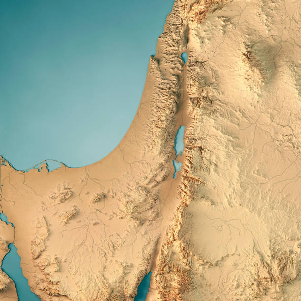
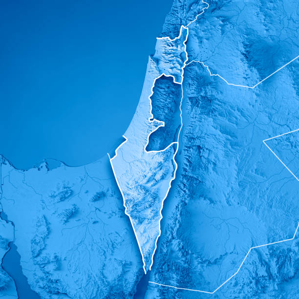
3D render of a topographic map of Israel and Palestine. All source data is in the public domain. SRTM data courtesy of the U.S. Geological Survey.
3D Render of a Topographic Map of Israel, Middle East. All source data is in the public domain. Color texture: Made with Natural Earth. http://www.naturalearthdata.com/downloads/10m-raster-data/10m-cross-blend-hypso/ Boundaries Level 0: Humanitarian Information Unit HIU, U.S. Department of State (database: LSIB) http://geonode.state.gov/layers/geonode%3ALSIB7a_Gen Relief texture and Rivers: SRTM data courtesy of USGS. URL of source image: https://e4ftl01.cr.usgs.gov//MODV6_Dal_D/SRTM/SRTMGL1.003/2000.02.11/ Water texture: SRTM Water Body SWDB: https://dds.cr.usgs.gov/srtm/version2_1/SWBD/

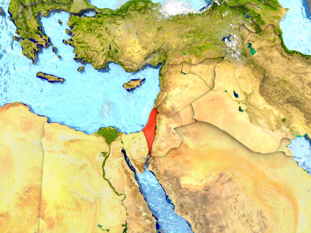
Top-down view of Israel highlighted in red with surrounding region. 3D illustration with highly detailed realistic planet surface. 3D model of planet created and rendered in Cheetah3D software, 4 Mar 2017. Some layers of planet surface use textures furnished by NASA, Blue Marble collection: http://visibleearth.nasa.gov/view_cat.php?categoryID=1484

Israel from space in red. 3D illustration with highly detailed realistic planet surface. 3D model of planet created and rendered in Cheetah3D software, 9 Mar 2017. Some layers of planet surface use textures furnished by NASA, Blue Marble collection: http://visibleearth.nasa.gov/view_cat.php?categoryID=1484

Israel with embedded flag on planet surface during sunrise. 3D illustration with highly detailed realistic planet surface and visible city lights. 3D model of planet created and rendered in Cheetah3D software, 9 Mar 2017. Some layers of planet surface use textures furnished by NASA, Blue Marble collection: http://visibleearth.nasa.gov/view_cat.php?categoryID=1484

Haifa map, satellite view, city, Israel. 3d rendering
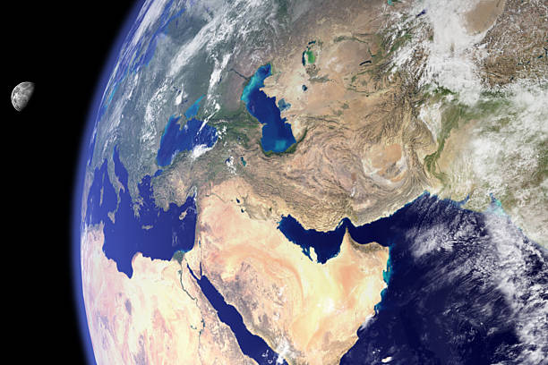
"3D render and image composing: Topographic Map of the Middle East region. Including borders, rivers and accurate longitude/latitude lines. High resolution available! High quality relief structure!Relief texture and satellite images courtesy of NASA. Further data source courtesy of CIA World Data Bank II database.Related images:"
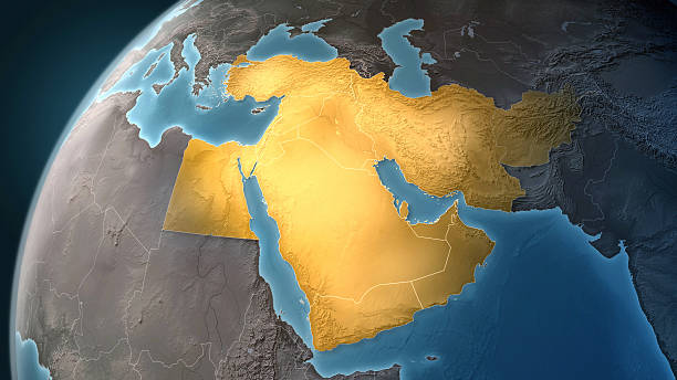
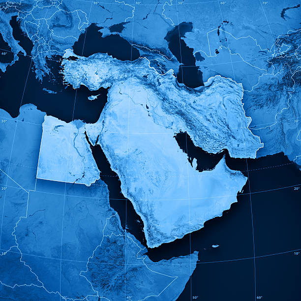
Map of Middle East on a Earth globe, looking west to Europe. Turkey, Syria, Lebanon, Israel, Jordan, Egypt, Saudi Arabia, Yemen, Oman, Qatar, United Arab Emirates, Kuwait, Iraq, Iran and Afghanistan are the main focus. Countries are highlighted in yellow, while seas are deep blue and land are brown gray. Europe and North Africa are also included in the frame, together with Mediterranean Sea and Persian Gulf. Physical and geographical features are visible. Geopolitics and diplomacy connected to history and geography. Map is blank, without country names. For illustration puroposes only, country grouping and current borders status may differ.

3D Render of a Topographic Map of the Middle East region including Jordan and Syria. All source data is in the public domain. Color texture: Made with Natural Earth. http://www.naturalearthdata.com/downloads/10m-raster-data/10m-cross-blend-hypso/ Relief texture: NASADEM data courtesy of NASA JPL (2020). URL of source image: https://doi.org/10.5067/MEaSUREs/NASADEM/NASADEM_HGT.001 Water texture: SRTM Water Body SWDB: https://dds.cr.usgs.gov/srtm/version2_1/SWBD/ Boundaries Level 0: Humanitarian Information Unit HIU, U.S. Department of State (database: LSIB) http://geonode.state.gov/layers/geonode%3ALSIB7a_Gen

Middle East region from Earth's orbit in space during sunrise. 3D illustration with highly detailed realistic planet surface. 3D model of planet created and rendered in Cheetah3D software, 8 Mar 2017. Some layers of planet surface use textures furnished by NASA, Blue Marble collection: http://visibleearth.nasa.gov/view_cat.php?categoryID=1484
3D Render of a Topographic Map of Israel, Middle East. All source data is in the public domain. Boundaries Level 0: Humanitarian Information Unit HIU, U.S. Department of State (database: LSIB) http://geonode.state.gov/layers/geonode%3ALSIB7a_Gen Relief texture and Rivers: SRTM data courtesy of USGS. URL of source image: https://e4ftl01.cr.usgs.gov//MODV6_Dal_D/SRTM/SRTMGL1.003/2000.02.11/ Water texture: SRTM Water Body SWDB: https://dds.cr.usgs.gov/srtm/version2_1/SWBD/

Israeli first lunar lander Beresheet spacecraft successful first maneuver around the moon.Flag Israel on the moon.Elements of this image furnished by NASA

3D Render of a Topographic Map of Israel, Middle East. All source data is in the public domain. Relief texture and Rivers: SRTM data courtesy of USGS. URL of source image: https://e4ftl01.cr.usgs.gov//MODV6_Dal_D/SRTM/SRTMGL1.003/2000.02.11/ Water texture: SRTM Water Body SWDB: https://dds.cr.usgs.gov/srtm/version2_1/SWBD/

Credit: https://www.nasa.gov/topics/earth/images An illustrative stock image showcasing the distinctive tricolor flag of Israel beautifully draped across a detailed map of the country, symbolizing the rich history and culture

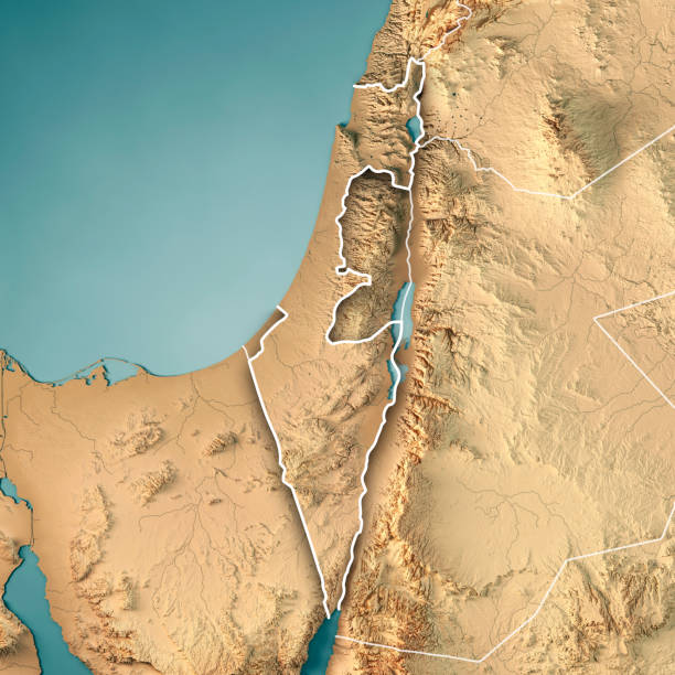
3D Render of a Topographic Map of the Middle East region including Jordan and Syria. Version with Country Boundaries and Cities. All source data is in the public domain. Color texture: Made with Natural Earth. http://www.naturalearthdata.com/downloads/10m-raster-data/10m-cross-blend-hypso/ Relief texture: NASADEM data courtesy of NASA JPL (2020). URL of source image: https://doi.org/10.5067/MEaSUREs/NASADEM/NASADEM_HGT.001 Water texture: SRTM Water Body SWDB: https://dds.cr.usgs.gov/srtm/version2_1/SWBD/ Boundaries Level 0: Humanitarian Information Unit HIU, U.S. Department of State (database: LSIB) http://geonode.state.gov/layers/geonode%3ALSIB7a_Gen

Super high quality rendering of earth. Uncompromising detail. Please zoom in!My Earth renderings are absolutely photorealistic and offer a higher resolution and quality than many satellite pictures.
Map of the Arabian Peninsula, Middle East physical map, 3d render, reliefs and mountains. Mediterranean. Israel, Turkey, Syria, Iraq, Jordan, Egypt, Iran, Saudi Arabia. Satellite view. Elements of this image are furnished by Nasa

Israel at night as seen from Earth's orbit in space. 3D illustration with highly detailed realistic planet surface and city lights. 3D model of planet created and rendered in 5 Mar 2017. Some layers of planet surface use textures furnished by NASA, Blue Marble collection: http://visibleearth.nasa.gov/view_cat.php?categoryID=1484

"Highly detailed vector map of Israel. File was created on August 17, 2012. The colors in the .eps-file are ready for print (CMYK). Included files: EPS (v8) and Hi-Res JPG (2800 x 2800 px)."

"3D render and image composing: Topographic Map of the State of Israel. Including country borders, rivers and accurate longitude/latitude lines. High quality relief structure!Relief texture and satellite images courtesy of NASA. Further data source courtesy of CIA World Data Bank II database.Related images:"
3D Render of a Topographic Map of Israel, Middle East. All source data is in the public domain. Boundaries Level 0: Humanitarian Information Unit HIU, U.S. Department of State (database: LSIB) http://geonode.state.gov/layers/geonode%3ALSIB7a_Gen Relief texture and Rivers: SRTM data courtesy of USGS. URL of source image: https://e4ftl01.cr.usgs.gov//MODV6_Dal_D/SRTM/SRTMGL1.003/2000.02.11/ Water texture: SRTM Water Body SWDB: https://dds.cr.usgs.gov/srtm/version2_1/SWBD/

Topographic Map with a marker at the city of Jerusalem, Israel. 3D Rendering with accurate longitude and latitude. Very high resolution available! High quality relief structure!

Middle east is burning in the picture because of wars and chaos. Moon and earth from nasa, i used Adobe Photoshop CS6 http://earthobservatory.nasa.gov/NaturalHazards/view.php?id=79793 http://moon.nasa.gov/image-display.cfm?IM_ID=19167 Clip art and illustration.

3D Render of a Topographic Map of the Middle East region including Syria and Iraq. All source data is in the public domain. Color texture and Rivers: Made with Natural Earth. http://www.naturalearthdata.com/downloads/10m-raster-data/10m-cross-blend-hypso/ http://www.naturalearthdata.com/downloads/10m-physical-vectors/ Relief texture: SRTM data courtesy of USGS. URL of source image: https://e4ftl01.cr.usgs.gov//MODV6_Dal_D/SRTM/SRTMGL1.003/2000.02.11/ Water texture: HIU World Water Body Limits: http://geonode.state.gov/layers/?limit=100&offset=0&title__icontains=World%20Water%20Body%20Limits%20Detailed%202017Mar30

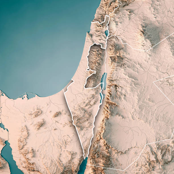
3D render of a topographic map of Israel. All source data is in the public domain. SRTM data courtesy of the U.S. Geological Survey.
Israel in red on map with detailed landmass texture, realistic watery oceans and clouds above the surface. 3D illustration. 3D model of planet created and rendered in Cheetah3D software, 7 Mar 2017. Some layers of planet surface use textures furnished by NASA, Blue Marble collection: http://visibleearth.nasa.gov/view_cat.php?categoryID=1484

3D render and image composing: Topographic Map of the Middle East region. Isolated on White. High resolution available! High quality relief structure!


Earth globe image provided by NASA

Tel Aviv, Jaffa, map, satellite view, city, Israel. 3d rendering
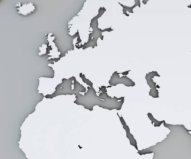
Map of the Mediterranean Sea and Europe, Africa and the Middle East. Cartography, geographical atlas. White map

Map of Israel in red on planet Earth. 3D illustration with detailed planet surface. 3D model of planet created and rendered in Cheetah3D software, 5 Mar 2017. Some layers of planet surface use textures furnished by NASA, Blue Marble collection: http://visibleearth.nasa.gov/view_cat.php?categoryID=1484


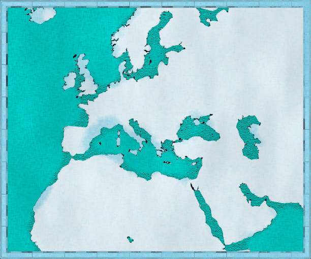
Map of the Mediterranean Sea and Europe, Africa and the Middle East. Cartography, geographical atlas. Drawn illustrated brush strokes, geographical map, physics

3D Render of a Topographic Map of Israel, Middle East. All source data is in the public domain. Relief texture and Rivers: SRTM data courtesy of USGS. URL of source image: https://e4ftl01.cr.usgs.gov//MODV6_Dal_D/SRTM/SRTMGL1.003/2000.02.11/ Water texture: SRTM Water Body SWDB: https://dds.cr.usgs.gov/srtm/version2_1/SWBD/

Credit: https://www.nasa.gov/topics/earth/images Take a virtual trip to Israel today and enhance your understanding of this beautiful land. Get ready to be captivated by the geography, history, and culture of Israel

3D render of a topographic map of Palestine. All source data is in the public domain. SRTM data courtesy of the U.S. Geological Survey.

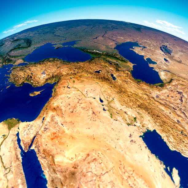
The rugged and arid Middle East! Captured from an Aerial view you can see the vastness of the Holy Land and its mountainous terrain.

Dusk over Israel highlighted in red with city lights as seen from Earth's orbit in space. 3D illustration with highly detailed realistic planet surface. 3D model of planet created and rendered in Cheetah3D software, 5 Mar 2017. Some layers of planet surface use textures furnished by NASA, Blue Marble collection: http://visibleearth.nasa.gov/view_cat.php?categoryID=1484

Israel highlighted red on highly detailed model of planet Earth with visible city lights, plastic oceans and mountain ranges. 3D illustration isolated on white background. 3D model of planet created and rendered in Cheetah3D software, 7 Mar 2017. Some layers of planet surface use textures furnished by NASA, Blue Marble collection: http://visibleearth.nasa.gov/view_cat.php?categoryID=1484

Israel in red on model of planet Earth. 3D illustration with highly detailed realistic planet surface and clouds. 3D model of planet created and rendered in Cheetah3D software, 5 Mar 2017. Some layers of planet surface use textures furnished by NASA, Blue Marble collection: http://visibleearth.nasa.gov/view_cat.php?categoryID=1484

Israel with embedded national flag as if seen from Earth's orbit in space. 3D illustration with highly detailed realistic planet surface. 3D model of planet created and rendered in Cheetah3D software, 5 Mar 2017. Some layers of planet surface use textures furnished by NASA, Blue Marble collection: http://visibleearth.nasa.gov/view_cat.php?categoryID=1484

Israel in red at night as seen from Earth's orbit in space. 3D illustration with highly detailed realistic planet surface. 3D model of planet created and rendered in Cheetah3D software, 5 Mar 2017. Some layers of planet surface use textures furnished by NASA, Blue Marble collection: http://visibleearth.nasa.gov/view_cat.php?categoryID=1484

Israel highlighted in red on Earth as seen from Earth's orbit in space during sunset. 3D illustration with highly detailed realistic planet surface. 3D model of planet created and rendered in Cheetah3D software, 5 Mar 2017. Some layers of planet surface use textures furnished by NASA, Blue Marble collection: http://visibleearth.nasa.gov/view_cat.php?categoryID=1484

Israeli first lunar lander Beresheet spacecraft Performed a Successful Lunar Capture on the Moon. Flag Israel on the moon. Elements of this image furnished by NASA.

Israel highlighted in red on model of planet Earth with very detailed land surface and visible city lights. 3D illustration. 3D model of planet created and rendered in Cheetah3D software, 7 Mar 2017. Some layers of planet surface use textures furnished by NASA, Blue Marble collection: http://visibleearth.nasa.gov/view_cat.php?categoryID=1484

Dusk over Israel highlighted in red with city lights as seen from Earth's orbit in space. 3D illustration with highly detailed realistic planet surface. 3D model of planet created and rendered in Cheetah3D software, 4 Mar 2017. Some layers of planet surface use textures furnished by NASA, Blue Marble collection: http://visibleearth.nasa.gov/view_cat.php?categoryID=1484

Israel in red on a globe with reflective ocean waters. 3D illustration with highly detailed realistic planet surface. 3D model of planet created and rendered in Cheetah3D software, 4 Mar 2017. Some layers of planet surface use textures furnished by NASA, Blue Marble collection: http://visibleearth.nasa.gov/view_cat.php?categoryID=1484

Israel in red with surrounding region. 3D illustration with highly detailed realistic planet surface. 3D model of planet created and rendered in Cheetah3D software, 4 Mar 2017. Some layers of planet surface use textures furnished by NASA, Blue Marble collection: http://visibleearth.nasa.gov/view_cat.php?categoryID=1484


Top-down view of Israel hightlighted in red as seen from Earth's orbit in space. 3D illustration with highly detailed realistic planet surface. 3D model of planet created and rendered in Cheetah3D software, 4 Mar 2017. Some layers of planet surface use textures furnished by NASA, Blue Marble collection: http://visibleearth.nasa.gov/view_cat.php?categoryID=1484

Israel highlighted in red on Earth. 3D illustration with highly detailed realistic planet surface isolated on white background. 3D model of planet created and rendered in Cheetah3D software, 4 Mar 2017. Some layers of planet surface use textures furnished by NASA, Blue Marble collection: http://visibleearth.nasa.gov/view_cat.php?categoryID=1484


Israel highlighted in red on planet Earth. 3D illustration isolated on white background. 3D model of planet created and rendered in Cheetah3D software, 5 Mar 2017.

Israel on planet Earth. 3D illustration with detailed realistic planet surface. 3D model of planet created and rendered in Cheetah3D software, 5 Mar 2017. Some layers of planet surface use textures furnished by NASA, Blue Marble collection: http://visibleearth.nasa.gov/view_cat.php?categoryID=1484
Next