
Kırşehir Pictures, Images and Stock Photos
Browse 1,000+ kırşehir stock photos and images available, or search for safranbolu to find more great stock photos and pictures.
Most popular

Unidentified Turkish people with village view on a steppe land in kırşehir middle anatolia turkey, there are Agriculture planting areas with adobe house in village in kırşehir turkey in a sunny day.


Kırşehir, Turkey - July 1, 2021: Kesikkopru Caravanserai was built in the 13th century during the Anatolian Seljuk period. A photograph of the caravanserai taken with a drone. The Kesik Bridge is located on the Kizilirmak River.


Kalehöyük is 3 km away from Kaman district of Kırşehir province. The mound is a typical Anatolian mound with a diameter of 280 m and a height of 16 m. The Kaman Kalehöyük excavations were initiated by Prince Takahito Mikasa, President of the Japan Middle East Cultural Center and Honorary Chairman of the Kaman Kalehöyük Excavation Committee, on 31 May 1986. Dr. The excavation, led by Sachihiro Omura, is still ongoing. The earliest settlement is dated to the early Bronze age. During the excavations carried out in the mound, the existence of a settlement that started from the Early Bronze Age and continued until the Ottoman period was determined. BC in Kalehöyük. II. The Assyrian Trade Colonies Age, which took place in the 1000 BC, shows itself in the finds of Kaman Kalehöyük. At the same time, there are settlements belonging to the old and late Hittite, old and late Phrygian phases.

Unidentified Turkish people with village view on a steppe land in kırşehir middle anatolia turkey, there are Agriculture planting areas with adobe house in village in kırşehir turkey in a sunny day.

Full orange moon in the dark sky in istanbul turkey
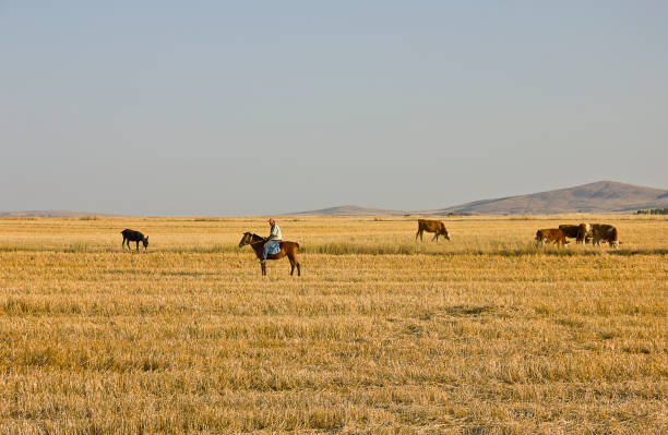
Kırşehir, Turkey - August 9, 2023: Dairy farm view with shepherd on a steppe land in kırşehir middle anatolia turkey, there are dairy farms and Agriculture planting areas with adobe house in village in kırşehir turkey in a sunny day. Village view on a steppe land in kırşehir middle anatolia turkey, there are Agriculture planting areas with adobe house in village in kırşehir turkey in a sunny day.

the barley harvesting with tractor on field in summer time.

An aerial view of rocks formations under blue bright sky in Cappadocia

Kırşehir, Turkey - July 11, 2021: Kırsehir center view at summer time, people on the square to see the Mosque and Tomb, which was built in 1482 in the name of Ahi Evran, the founder of the Ahilik Organization, is located in the city center of Kırşehir.

Kırşehir, Turkey - July 1, 2021: The Kesik Bridge is located on the Kizilirmak River. The bridge was built in 1248 during the Anatolian Seljuk period. A photograph of the bridge taken with a drone.

Asia, Turkey - Middle East, Anatolia, Arabic Style, Architectural Dome

Ortahisar, Cappadocia, Turkey. September 19th 2018 "nBoza is a traditional Turkish fermented malt drink made from bulgar, rice, yeast and chick peas with cinamon

Mucur Sinkhole (Kırşehir, Türkiye)

Kırşehir, Turkey - August 8, 2023: Dairy farm view with shepherd on a steppe land in kırşehir middle anatolia turkey, there are dairy farms and Agriculture planting areas with adobe house in village in kırşehir turkey in a sunny day. Village view on a steppe land in kırşehir middle anatolia turkey, there are Agriculture planting areas with adobe house in village in kırşehir turkey in a sunny day.

Kırşehir, Turkey - July 11, 2021: Kırsehir center view at summer time, people on the square to kent park in kırşehir turkey. There are city logo in the park, restaurants, cafes and benches for resting.

Agriculture planting areas with adobe house. village landscape kırşehir turkey


Mucur Sinkhole (Kırşehir, Türkiye)

Kesikköprü Caravanserai was built in the 13th century during the Anatolian Seljuk period. A photograph of the caravanserai taken with a drone.

Dairy farm view with farmers feeding calfs on a steppe land in kırşehir middle anatolia turkey, there are dairy farms and Agriculture planting areas with adobe house in village in kırşehir turkey in a sunny day.

Kırşehir, Turkey - July 10, 2021: Kalehöyük japanese garden view which is 3 km away from Kaman district of Kırşehir province. The mound is a typical Anatolian mound with a diameter of 280 m and a height of 16 m. The Kaman Kalehöyük excavations were initiated by Prince Takahito Mikasa, President of the Japan Middle East Cultural Center and Honorary Chairman of the Kaman Kalehöyük Excavation Committee, on 31 May 1986. Dr. The excavation, led by Sachihiro Omura, is still ongoing. The earliest settlement is dated to the early Bronze age. During the excavations carried out in the mound, the existence of a settlement that started from the Early Bronze Age and continued until the Ottoman period was determined. BC in Kalehöyük. II. The Assyrian Trade Colonies Age, which took place in the 1000 BC, shows itself in the finds of Kaman Kalehöyük. At the same time, there are settlements belonging to the old and late Hittite, old and late Phrygian phases.

Dairy farm view with farmers feeding calfs on a steppe land in kırşehir middle anatolia turkey, there are dairy farms and Agriculture planting areas with adobe house in village in kırşehir turkey in a sunny day.

Dairy farm view with farmers feeding calfs on a steppe land in kırşehir middle anatolia turkey, there are dairy farms and Agriculture planting areas with adobe house in village in kırşehir turkey in a sunny day.

Ortahisar, Cappadocia, Turkey. September 19th 2018 "nChickpeas roasting "nBoza is a traditional Turkish fermented malt drink made from bulgar, rice, yeast and chick peas with cinamon

Village view on a steppe land in kırşehir middle anatolia turkey, there are Agriculture planting areas with adobe house in village in kırşehir turkey in a sunny day.

Village view on a steppe land in kırşehir middle anatolia turkey, there are Agriculture planting areas with adobe house in village in kırşehir turkey in a sunny day.

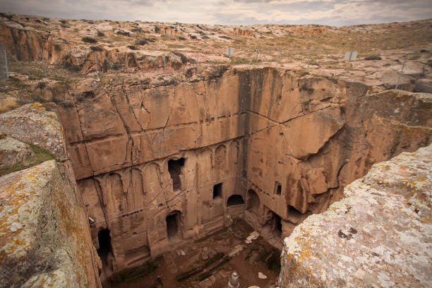
During the Roman period, M.S. It was seen that Christianity spread rapidly in the region in the 2nd century, and there was a great struggle between the idolaters and the Christians. Many underground cities in the Cappadocia region, which belong to the 3rd and 4th centuries, were built by Christians for protection, shelter and worship. Mucur Underground City is in Kırşehir province. The underground city carved into soft rocks is 7-8 m deep from the ground. In the underground city with many rooms, the corridors are wide enough to pass from one place to another and people can only move forward by bending, the barns, places of worship, dividing the corridors, and the capstones, which are large volumes and circular shaped stone masses that are estimated to be built to close the rooms. and there are ventilation shafts opening above ground.

White stork in flight against on blue sky background kırşehir turkey

Agriculture planting areas with adobe house. village landscape kırşehir turkey

Kırşehir, Turkey - July 22, 2021: Dairy farm view with shepherd on a steppe land in kırşehir middle anatolia turkey, there are dairy farms and Agriculture planting areas with adobe house in village in kırşehir turkey in a sunny day.Village view on a steppe land in kırşehir middle anatolia turkey, there are Agriculture planting areas with adobe house in village in kırşehir turkey in a sunny day.

Kırşehir, Turkey - July 22, 2021: Dairy farm view with shepherd on a steppe land in kırşehir middle anatolia turkey, there are dairy farms and Agriculture planting areas with adobe house in village in kırşehir turkey in a sunny day.Village view on a steppe land in kırşehir middle anatolia turkey, there are Agriculture planting areas with adobe house in village in kırşehir turkey in a sunny day.
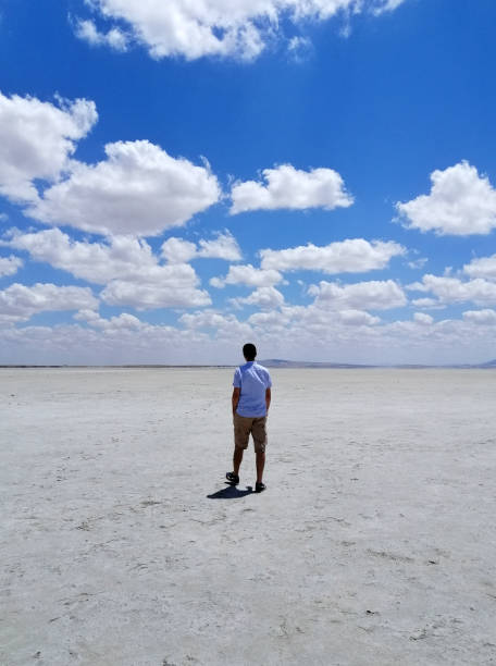
Kırşehir, Turkey - July 11, 2021: Young man walking on Seyfe Lake which is a shallow, 15 km² tectonic lake located 35 kilometers east of Kırşehir. It is seen that Lake Seyfe, whose water decreases in summer, swells in winter due to heavy rainfall and turns into a swamp around it. Around 25 bird species also visit the "Bird Paradise", where 50 different bird species incubate and 182 bird species shelter during migration.

Dairy farm view with farmers feeding calfs on a steppe land in kırşehir middle anatolia turkey, there are dairy farms and Agriculture planting areas with adobe house in village in kırşehir turkey in a sunny day.

Kırşehir, Turkey - July 22, 2021: Dairy farm view with farmers feeding calfs on a steppe land in kırşehir middle anatolia turkey, there are dairy farms and Agriculture planting areas with adobe house in village in kırşehir turkey in a sunny day.

Black hen close-up in the foreground in profile walks along with other chickens in kırşehir turkey

Dairy farm view with farmers feeding calfs on a steppe land in kırşehir middle anatolia turkey, there are dairy farms and Agriculture planting areas with adobe house in village in kırşehir turkey in a sunny day.

Kırsehir center view with castle at summer time, people on the square to kent park in kırşehir turkey. There are city logo in the park, restaurants, cafes and benches for resting.

Dairy farm view with farmers feeding calfs on a steppe land in kırşehir middle anatolia turkey, there are dairy farms and Agriculture planting areas with adobe house in village in kırşehir turkey in a sunny day.

Agriculture planting areas with adobe house. village landscape kırşehir turkey

Asia, Turkey - Middle East, Anatolia, Arabic Style, Architectural Dome

Kırşehir, Turkey - August 9, 2023: Dairy farm view with shepherd on a steppe land in kırşehir middle anatolia turkey, there are dairy farms and Agriculture planting areas with adobe house in village in kırşehir turkey in a sunny day. Village view on a steppe land in kırşehir middle anatolia turkey, there are Agriculture planting areas with adobe house in village in kırşehir turkey in a sunny day.

harvesting green lentil on field in summer time.

During the Roman period, M.S. It was seen that Christianity spread rapidly in the region in the 2nd century, and there was a great struggle between the idolaters and the Christians. Many underground cities in the Cappadocia region, which belong to the 3rd and 4th centuries, were built by Christians for protection, shelter and worship. Mucur Underground City is in Kırşehir province. The underground city carved into soft rocks is 7-8 m deep from the ground. In the underground city with many rooms, the corridors are wide enough to pass from one place to another and people can only move forward by bending, the barns, places of worship, dividing the corridors, and the capstones, which are large volumes and circular shaped stone masses that are estimated to be built to close the rooms. and there are ventilation shafts opening above ground.

The Cappadocian Region located in the center of the Anatolian Region of Turkey, with its valley, canyon, hills and unusual rock formation created as a result of the eroding rains and winds of thousands of years of the level, lava-covered plain located between the volcanic mountains Erciyes.

Agriculture planting areas with adobe house. village landscape kırşehir turkey

The Mosque and Tomb, which was built in 1482 in the name of Ahi Evran, the founder of the Ahilik Organization, is located in the city center of Kırşehir.


Kırşehir, Turkey - July 22, 2021: Dairy farm view with farmers feeding calfs on a steppe land in kırşehir middle anatolia turkey, there are dairy farms and Agriculture planting areas with adobe house in village in kırşehir turkey in a sunny day.


Asia, Turkey - Middle East, Anatolia, Arabic Style, Architectural Dome

Village view on a steppe land in kırşehir middle anatolia turkey, there are Agriculture planting areas with adobe house in village in kırşehir turkey in a sunny day.

Kırşehir, Turkey - July 24, 2021: Unidentified Turkish people who is farm worker wearing traditional clothes in steppe with a small tractor in kırşehir turkey. They are harvesting the lentil on field in summer time.

Tomato Sprout Growth, Sunset kırşehir turkey

Full orange moon in the dark sky in kırşehir turkey

Asia, Turkey - Middle East, Anatolia, Arabic Style, Architectural Dome

Kırşehir, Turkey - August 9, 2023: Dairy farm view with shepherd on a steppe land in kırşehir middle anatolia turkey, there are dairy farms and Agriculture planting areas with adobe house in village in kırşehir turkey in a sunny day. Village view on a steppe land in kırşehir middle anatolia turkey, there are Agriculture planting areas with adobe house in village in kırşehir turkey in a sunny day.
Next