
Laguna Colorada Bolivia Pictures, Images and Stock Photos
Browse 2,200+ laguna colorada bolivia stock photos and images available, or start a new search to explore more stock photos and images.
Most popular
Laguna Colorada, Red Lagoon, is a shallow salt lake in the southwest of the altiplano of Bolivia, within Eduardo Avaroa Andean Fauna National Reserve and close to the border with Chile
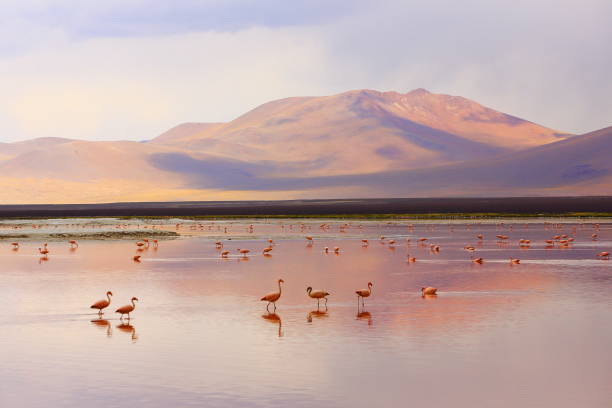
Group of pink flamingos in the colorful water of Laguna Colorada, a popular stop on the Roadtrip to Uyuni Salf Flat, Bolivia

Two James's flamingos in the Laguna Colorada in the Bolivian Andes. Also known as the puna flamingo, is populates in high altitudes of Andean plateaus in Peru, Chile

Laguna Colorada landscape,Bolivia. Beautiful bolivian panorama. Red water lagoon

One llama walking by the Red Lagoon (Laguna Colorada) located near the Uyuni Salt Flat, Bolivia.

Cute llama looking at the camera next to Laguna Colorada in the Bolivian Altiplano

Red waters of Laguna Colorada, Altiplano, Bolivia

Laguna Colorada, means Red Lake is a shallow salt lake in the southwest of the Altiplano of Bolivia

Scenic panoramic view on Laguna Colorada in Bolivia with Mountain Peaks of Andes and blue sky with clouds in the background and Red Lake Water and White Sand with flamingos
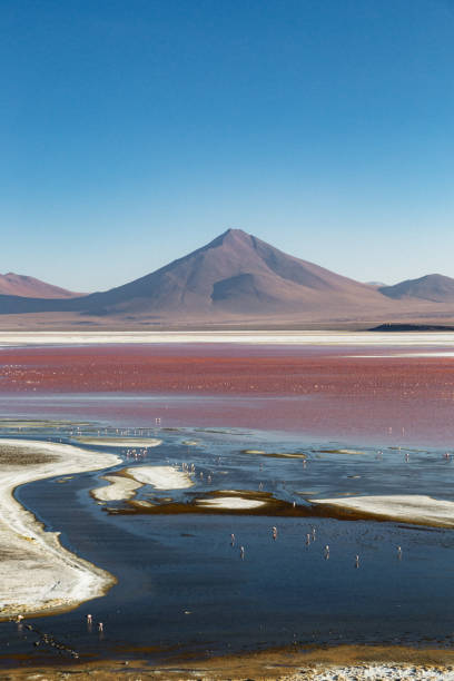
Scenic view of Laguna Colorada and volcano peak on background at the sunset in Altiplano, Bolivia

Female tourist looking at Laguna Colorada in Bolivia. The Altiplano (Spanish for high plain), in west-central South America, where the Andes are at their widest, is the most extensive area of high plateau on earth outside of Tibet. Lake Titicaca is its best known geographical feature. The Altiplano is an area of inland drainage (endorheism) lying in the central Andes, occupying parts of Northern Chile and Argentina, Western Bolivia and Southern Peru. Its height averages about 3,750 meters (12,300 feet), slightly less than that of Tibet. Unlike the Tibetan Plateau, however, the Altiplano is dominated by massive active volcanoes of the Central Volcanic Zone to the west like Ampato (6288 m), Tutupaca (5816 m), Nevado Sajama (6542 m), Parinacota (6348 m), Guallatiri (6071 m), Cerro Paroma (5728 m), Cerro Uturuncu (6008 m) and Licancabur (5916 m), and the Cordillera Real in the north east with Illampu (6368 m), Huayna Potosi (6088 m), Ancohuma (6427 m) and Illimani (6438 m). The Atacama Desert, one of the driest areas on the whole planet, lies to the southwest of the Altiplano. In contrast, to the east lies the humid Amazon Rainforest.

Shore of the Laguna Colorada (Red Lagoon) with Andes grass and ice in winter, Uyuni salt flat desert, Bolivia.

Stunning panoramic view of pink james flamingos at Laguna Colorada (lagoon). Beautiful landscape of spectacular Bolivian Andes and Altiplano in magnificent Siloli Desert, near Salar de Uyuni, Bolivia


Caucasian man is sitting on the rock and looking at scenic view of Laguna Colorada with flamingoes at the sunset in Altiplano, Bolivia

37MPix XXXXL size - this panoramic landscape is an very high resolution multi-frame composite and is suitable for large scale printing. Sunrise over Laguna Colorada, Bolivian Altiplano. The Altiplano (Spanish for high plain), in west-central South America, where the Andes are at their widest, is the most extensive area of high plateau on earth outside of Tibet. Lake Titicaca is its best known geographical feature. The Altiplano is an area of inland drainage (endorheism) lying in the central Andes, occupying parts of Northern Chile and Argentina, Western Bolivia and Southern Peru. Its height averages about 3,750 meters (12,300 feet), slightly less than that of Tibet.

Sunrise over Laguna Colorada, Bolivian Altiplano. The Altiplano (Spanish for high plain), in west-central South America, where the Andes are at their widest, is the most extensive area of high plateau on earth outside of Tibet. Lake Titicaca is its best known geographical feature. The Altiplano is an area of inland drainage (endorheism) lying in the central Andes, occupying parts of Northern Chile and Argentina, Western Bolivia and Southern Peru. Its height averages about 3,750 meters (12,300 feet), slightly less than that of Tibet. Unlike the Tibetan Plateau, however, the Altiplano is dominated by massive active volcanoes of the Central Volcanic Zone to the west like Ampato (6288 m), Tutupaca (5816 m), Nevado Sajama (6542 m), Parinacota (6348 m), Guallatiri (6071 m), Cerro Paroma (5728 m), Cerro Uturuncu (6008 m) and Licancabur (5916 m), and the Cordillera Real in the north east with Illampu (6368 m), Huayna Potosi (6088 m), Ancohuma (6427 m) and Illimani (6438 m). The Atacama Desert, one of the driest areas on the whole planet, lies to the southwest of the Altiplano. In contrast, to the east lies the humid Amazon Rainforest.

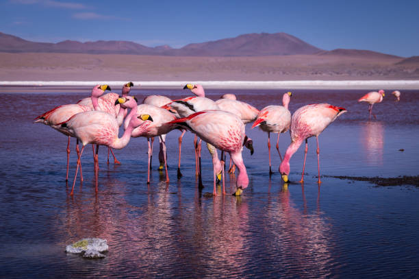
Laguna Colorada (red lake) with flamingos standing in the shallow water, Reserva de Fauna Andina Eduardo Avarda, Southwestern Highlands, Bolivia, South America

The colorful Canapa lagoon in the Andes mountain range of Bolivia with Andes grass, James and Andean flamingos as well as a white borax island near the Uyuni salt flat, South America.


James Flamingo (Phoenicoparrus jamesi) at Laguna Colorada (Bolivia)
Laguna Verde (green lagoon) with Licancabur volcano, Eduardo Avaroa wildlife reserve, Uyuni, Bolivia.

Lagunas escondidas of Baltinache – Hidden blue salt lakes of Baltinache and Atacama salar flats - Turquoise salt lakes mirrored reflection and Idyllic Atacama Desert, Volcanic landscape panorama – San Pedro de Atacama, Chile, Bolívia and Argentina border


View on laguna Colorada with flaminfos in the Andes of Bolivia


Scenic view of Laguna Colorada and volcano peak on background at the sunset in Altiplano, Bolivia

The Altiplano (Spanish for high plain), in west-central South America, where the Andes are at their widest, is the most extensive area of high plateau on earth outside of Tibet. Lake Titicaca is its best known geographical feature. The Altiplano is an area of inland drainage (endorheism) lying in the central Andes, occupying parts of Northern Chile and Argentina, Western Bolivia and Southern Peru. Its height averages about 3,750 meters (12,300 feet), slightly less than that of Tibet. Unlike the Tibetan Plateau, however, the Altiplano is dominated by massive active volcanoes of the Central Volcanic Zone to the west like Ampato (6288 m), Tutupaca (5816 m), Nevado Sajama (6542 m), Parinacota (6348 m), Guallatiri (6071 m), Cerro Paroma (5728 m), Cerro Uturuncu (6008 m) and Licancabur (5916 m), and the Cordillera Real in the north east with Illampu (6368 m), Huayna Potosi (6088 m), Ancohuma (6427 m) and Illimani (6438 m). The Atacama Desert, one of the driest areas on the whole planet, lies to the southwest of the Altiplano. In contrast, to the east lies the humid Amazon Rainforest.

The Altiplano (Spanish for high plain), in west-central South America, where the Andes are at their widest, is the most extensive area of high plateau on earth outside of Tibet. Lake Titicaca is its best known geographical feature. The Altiplano is an area of inland drainage (endorheism) lying in the central Andes, occupying parts of Northern Chile and Argentina, Western Bolivia and Southern Peru. Its height averages about 3,750 meters (12,300 feet), slightly less than that of Tibet. Unlike the Tibetan Plateau, however, the Altiplano is dominated by massive active volcanoes of the Central Volcanic Zone to the west like Ampato (6288 m), Tutupaca (5816 m), Nevado Sajama (6542 m), Parinacota (6348 m), Guallatiri (6071 m), Cerro Paroma (5728 m), Cerro Uturuncu (6008 m) and Licancabur (5916 m), and the Cordillera Real in the north east with Illampu (6368 m), Huayna Potosi (6088 m), Ancohuma (6427 m) and Illimani (6438 m). The Atacama Desert, one of the driest areas on the whole planet, lies to the southwest of the Altiplano. In contrast, to the east lies the humid Amazon Rainforest.

baby flamingo in Laguna Colorada, Bolivian altiplano

Beautiful landscape of Laguna Colorada in Bolivia

A small herd of llamas at Laguna Colorada, Bolivia

Laguna Colorada flamingos, Bolivia. Puna flamingo. Andean wildlife. Red lagoon

A desert area of Bolivia in the high mountains


Travel in Nambia, discovering the Salar de Uyuni and the Laguna colorada

Salar de Uyuni and Laguna Colorada

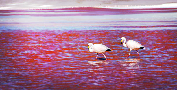
Two pink flamingos facing each other at "Laguna Colorada" (Multicolored Salty Lake), among the most important travel destination in Bolivia.

Bolivia's desert and its colors

Pink flamingos feeding in the salt water of "Laguna Hedionda" (eng. Hedionda Lake), among the most scenic travel destination in the Andean Highlands of Bolivia. Selective focus.

Bolivia's Laguna Colorada


Stunning panoramic view of pink james flamingos at Laguna Colorada (lagoon). Beautiful landscape of spectacular Bolivian Andes and Altiplano in magnificent Siloli Desert, near Salar de Uyuni, Bolivia

Travel in Nambia, discovering the Salar de Uyuni and the Laguna colorada

Travel in Nambia, discovering the Salar de Uyuni and the Laguna colorada


Amazing mountains and volcanos, flamingos and lamas on Altiplano plateau in Bolivia, South America.

Amazing mountains and volcanos, flamingos and lamas on Altiplano plateau in Bolivia, South America.

Laguna Colorada flamingos, Bolivia. Puna flamingo. Andean wildlife. Red lagoon

Salar de Uyuni and Laguna Colorada

Salar de Uyuni and Laguna Colorada

Single flamingo standing next to the famous Laguna Colorada, Bolivia. The lagoon is located high up on the Andean altiplano and surrounded by barren mountains.


Spectacular travel to Bolivia and Peru. After visiting the Uyuni desert we discover Bolivia and Laguna colorada

Flamingoes eating in Red Lagoon (Red Lake), Eduardo Avaroa andean fauna National Reserve, Bolivia
Next