
Physical Map Of Korea Pictures, Images and Stock Photos
Browse 40+ physical map of korea stock photos and images available, or start a new search to explore more stock photos and images.
Most popular
Highly detailed physical map of Asia in vector
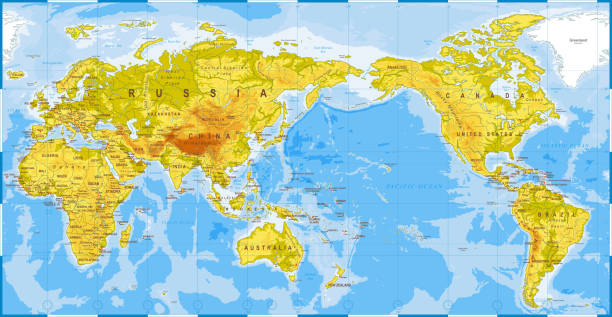
World Map Physical - Asia in Center - China, Korea, Japan - vector

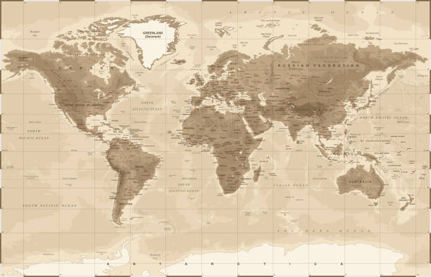
World Map Physical Vintage - Asia in Center - China, Korea, Japan - vector
World Map Physical Vintage - vector illustration
South Korea Physical Map. Vector illustration.

Korean Peninsula Detailed Physical Map Isolated on Retro White Color. Vector illustration. Image contains next layers:

Globe map of Japan, North Korea and South Korea, physical map Asia, East Asia. Map with reliefs and mountains and Pacific Ocean, atlas, cartography. Satellite view. China. 3d render Elements of this image are furnished by Nasa. https://visibleearth.nasa.gov/images/73801/september-blue-marble-next-generation-w-topography-and-bathymetry/73812l

South Korea Physical Map Isolated On Retro White Color. Vector illustration.

World Map Physical White - vector illustration

Physical map of Planet Earth, focused on Japan, North and South Korea. Satellite view of East Asia, sun shining on the horizon. 3D illustration (Blender software), elements of this image furnished by NASA (https://eoimages.gsfc.nasa.gov/images/imagerecords/147000/147190/eo_base_2020_clean_3600x1800.png)

Very Detailed Physical Map Of Asia From 1884 Available Up To XXXL Size.

Map of Japan, North Korea and South Korea, physical map Asia, East Asia, map with reliefs and mountains and Pacific Ocean, atlas, cartography. The map of Japan and the other countries was created by me in adobe illustrator. It is very defined in details because it is vector and scalable and has been completely elaborated in adobe photoshop. The source: https://visibleearth.nasa.gov/view.php?id=74393 https://visibleearth.nasa.gov/view_cat.php?categoryID=1484&p=3

Asia physical map with rivers, lakes and elevations.

3D Render of a Topographic Map of China. All source data is in the public domain. Color texture and lakes: Made with Natural Earth. http://www.naturalearthdata.com/downloads/10m-raster-data/10m-cross-blend-hypso/ https://www.naturalearthdata.com/downloads/10m-physical-vectors/ Relief texture: GMTED2010 data courtesy of USGS. URL of source image: https://topotools.cr.usgs.gov/gmted_viewer/viewer.htm Water texture: HIU World Water Body Limits: http://geonode.state.gov/layers/?limit=100&offset=0&title__icontains=World%20Water%20Body%20Limits%20Detailed%202017Mar30

World Map Physical White - Asia in Center - China, Korea, Japan - vector

Highly detailed physical map of Japan in vector

Topographic North Korea Map Hypsometric Elevation tint Spectral Shaded relief map 3d illustration Source Map Data: tangrams.github.io/heightmapper/ Software Cinema 4d
South Korea Physical Map. On White. Vector illustration.

3D Render of a Topographic Map of China. All source data is in the public domain. Color texture and lakes: Made with Natural Earth. http://www.naturalearthdata.com/downloads/10m-raster-data/10m-cross-blend-hypso/ https://www.naturalearthdata.com/downloads/10m-physical-vectors/ Relief texture: GMTED2010 data courtesy of USGS. URL of source image: https://topotools.cr.usgs.gov/gmted_viewer/viewer.htm Water texture: HIU World Water Body Limits: http://geonode.state.gov/layers/?limit=100&offset=0&title__icontains=World%20Water%20Body%20Limits%20Detailed%202017Mar30

Asia Physical Map with Rivers, Lakes and Elevations. Retro Colors.

Korean Peninsula large detailed physical map retro colors. Image contains next layers:

Retro color Korean Peninsula Physical Map. No text. Isolated on retro white. Vector illustration. Image contains next layers:

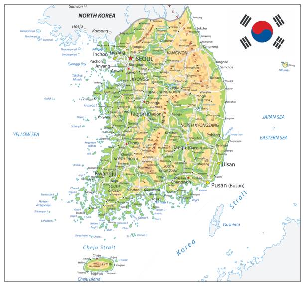
Korean Peninsula Map Physical Map with water objects, cities and capitals. Image contains next layers:


Asia Physical Map Retro Colors. No text

White and grey color physical map of Asia with rivers, lakes and elevations.

White and grey color physical map of Asia with rivers, lakes and elevations. No text.

South Korea Physical Map Isolated On White. No text. Vector illustration.

South Korea Physical Map Isolated On White. Vector illustration.

South Korea Physical Map. On White. No text. Vector illustration.

South Korea Physical Map. No text. Vector illustration.

South Korea Physical Map. Retro colors. No text. Vector illustration.

Asia Physical Map Retro White with Rivers, Lakes and Elevations.

South Korea Physical Map Isolated On Retro White Color. No text. Vector illustration.

Map of South East Asia, drawn illustrated brush strokes, geographical map, physics. Cartography, geographical atlas

Retro color Korean Peninsula Physical Map. No text. Vector illustration. Image contains next layers:


Vector physical map of East Asia stylized using embossed hexagons. Colored according to relief.

South Korea Physical Map Isolated On White. Vector illustration.

India. Realistic synoptic map of the India showing isobars and weather fronts. Meteorological forecast. Topography and physical map of country with national flag. Vector illustration EPS 10

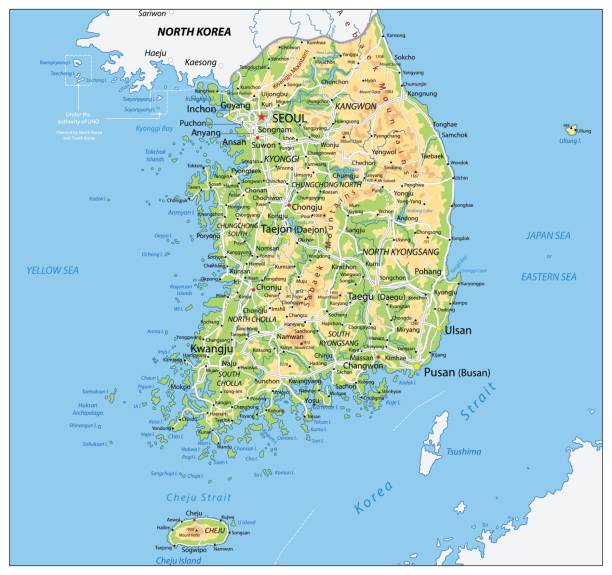
Korean Peninsula large detailed physical map with roads, railroads, water objects, cities and capitals.

Map of South East Asia, white geographical map. Cartography, geographical atlas. Grey background


South Korea Physical Map.Retro colors. Vector illustration.

Asia Physical Map Isolated on White. Vector illustration.

Asia Physical Map Isolated on White. No text. Vector illustration.

India. Realistic synoptic map of the India showing isobars and weather fronts. Meteorological forecast. Topography and physical map of country with national flag. Vector illustration EPS 10
