
Sioux City Pictures, Images and Stock Photos
Browse 130+ sioux city stock photos and images available, or search for sioux city iowa or sioux city iowa skyline to find more great stock photos and pictures.
Sunset over Veteran's Memorial Bridge in Sioux City over the Missouri River.

"Downtown Sioux City, IowaMore Sioux City images"

Evening drone photo of Veteran's Memorial Bridge in Sioux City Iowa and South Sioux City Nebraska.

View of downtown Sioux City, Iowa.

Sioux City is a city in Woodbury and Plymouth counties in the western part of the U.S. state of IowaMore Sioux City images

http://farm8.staticflickr.com/7189/6818724910_54c206caf8.jpg

Sioux City skyline Golden silhouette. Vector illustration.

"Street scene, downtown Sioux City, Iowa."

City Hall 1897

Sergeant Floyd Monument with winter snow and overcast with female visitor. Only member of Lewis and Clark Expedition to die on journey.

Sioux City skyline black and white silhouette with Reflections. Vector illustration.

Sioux City skyline black and white silhouette. Vector illustration.

Exterior view of the city hall in downtown Sioux City, Iowa.

Gran Canaria - April 2023: Sioux City is a Wild West-themed tourist attraction near San Agustin town. Designed to give visitors a taste of the American frontier through variety of shows and activities

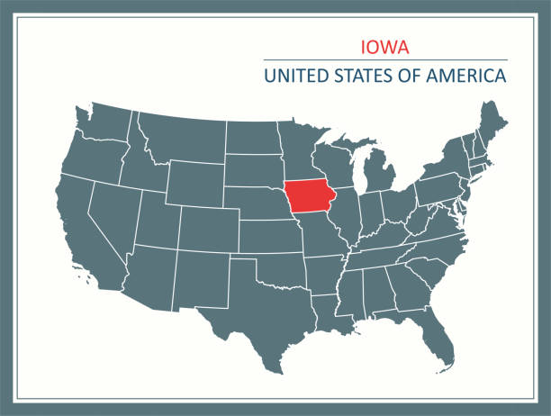
Highly detailed map of United States of America with highlighted state of Iowa for web banner, mobile, smartphone, iPhone, iPad applications and educational use. The map is accurately prepared by a map expert.

Outline Sioux City Iowa Skyline with Blue Buildings and Reflections. Vector Illustration. Business Travel and Tourism Illustration with Historic Architecture.

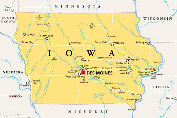
Iowa, IA, political map, with the capital Des Moines and most important cities, rivers and lakes. State in the Midwestern region of the United States of America, nicknamed The Hawkeye State. Vector.


Outline Sioux City Iowa Skyline with White Buildings. Vector Illustration. Business Travel and Tourism Concept with Historic Architecture. Sioux City Cityscape with Landmarks.

Sioux City Iowa Skyline with Color Buildings and Reflections Isolated on White Background. Vector Illustration. Business Travel and Tourism Illustration with Historic Architecture.

Downloadable outline vector map of Iowa state of United States of America.

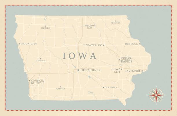
A vintage-style map of Iowa with freeways, highways and major cities. Shoreline, lakes and rivers are very detailed. Includes an EPS and JPG of the map without roads and cities.
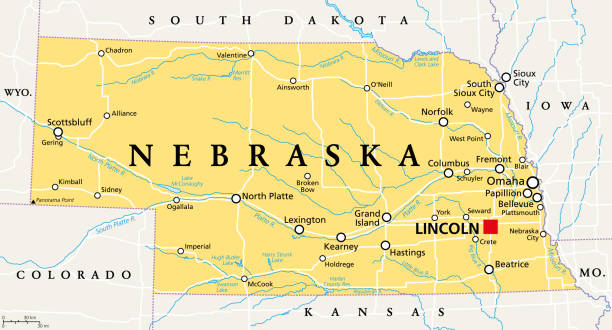
Nebraska, NE, political map with the capital Lincoln and the largest city Omaha. Triply landlocked State in the Midwestern subregion of the United States of America, nicknamed Cornhusker State. Vector

Truck and trailer in parking lot in Sioux City Iowa USA

Downtown Sioux City on the banks of the Missouri RiverMore Sioux City images

Sioux City Iowa City Skyline in Paper Cut Style with Snowflakes, Moon and Neon Garland. Vector Illustration. Christmas and New Year Concept. Santa Claus on Sleigh. Sioux City Cityscape and Landmarks.

Sioux City, Iowa


Outline Sioux City Iowa Skyline with Blue Buildings and Copy Space. Vector Illustration. Business Travel and Tourism Illustration with Historic Architecture.

Sioux City Iowa Skyline with Color Buildings, Blue Sky and Reflections. Vector Illustration. Business Travel and Tourism Illustration with Historic Architecture.

South Dakota, SD, political map, with capital Pierre, and largest city Sioux Falls. State in the upper Midwestern subregion of the United States of America, nicknamed The Mount Rushmore State. Vector.

Sioux City Iowa Skyline with Color Buildings Isolated on White Background. Vector Illustration. Business Travel and Tourism Illustration with Historic Architecture.

An exit sign for Sioux City on Interstate 29.

Sioux City Iowa Skyline with Color Buildings and Blue Sky. Vector Illustration. Business Travel and Tourism Illustration with Historic Architecture.

A train trestle crosses the Missouri River in Sioux city, Iowar. Illustration published 1886. Source: Original edition is from my own archives. Copyright has expired and is in Public Domain.

Sergeant Floyd Monument with winter snow and overcast with American Flag in foreground.

Sioux City Iowa Skyline with Color Buildings, Blue Sky and Copy Space. Vector Illustration. Business Travel and Tourism Illustration with Historic Architecture.

Label set with names of Iowa cities, vector illustration

Sioux City Iowa Skyline with Color Buildings. Vector Illustration. Business Travel and Tourism Illustration with Historic Architecture.

"Monument to the only lost member of the Lewis and Clark Expedition- Sergeant Floyd. Sioux City, IA"

The map is accurately prepared by a map expert.
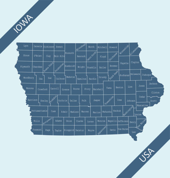
Highly detailed map of Iowa counties state of United States of America for web banner, mobile, smartphone, iPhone, iPad applications and educational use. The map is accurately prepared by a map expert.

Image relative to usa travel. Iowa state cities list. 3D rendering


Highly detailed map of iowa counties state of United States of America for book cover, brochure and web banner designs, iPhone, iPad, tablet, smart phone, mobile app and educational use.


Iowa, IA, gray political map, with the capital Des Moines and most important cities. State in the Midwestern region of the United States of America, nicknamed The Hawkeye State. Illustration. Vector.


19th century map of Iowa. Published in New Dollar Atlas of the United States and Dominion of Canada. (Rand McNally & Co's, Chicago, 1884).

The Dakotas, political map. Collective term for the U.S. states of North Dakota and South Dakota, in the Upper Midwest and North Central. Used to describe the Dakota Territory and collective heritage.
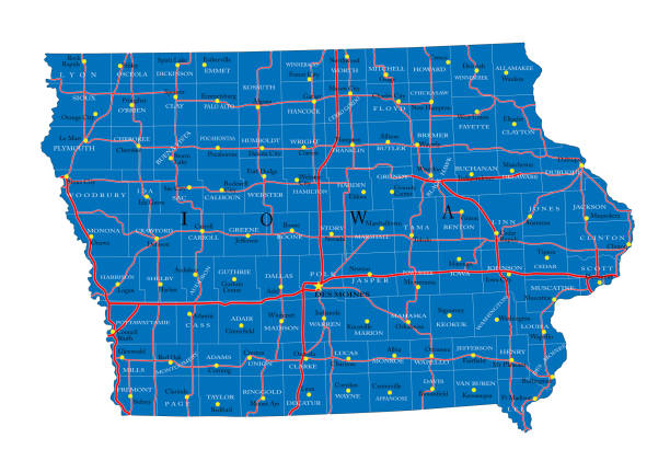
Detailed map of Iowa state,in vector format,with county borders,roads and major cities.


The townscape of Sioux City, Iowa during the fall season

A historic home on a hilltop during the fall in Sioux City, Iowa

Highly detailed map of United States of America with highlighted state of Iowa for web banner, mobile, smartphone, iPhone, iPad applications and educational use. The map is accurately prepared by a map expert.

Next