
Baghdad Map stock vectors
Browse 780+ baghdad map stock illustrations and vector graphics available royalty-free, or search for iraq to find more great stock images and vector art.
Most popular

Baghdad Iraq City Map in Retro Style in Golden Color. Outline Map. Vector Illustration.

Iraq political map of administrative divisions - governorates and Kurdistan Region. Solid blue blank vector map with white borders.

Vector illustration of Mao of Iraq.


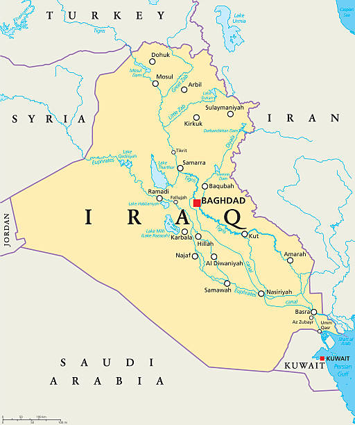
Iraq political map with capital Baghdad, national borders, important cities, rivers and lakes. Also called Mesopotamia, the land between Tigris and Euphrates. English labeling. Illustration.


http://dikobraz.org/map_2.jpg

3d isometric map of Middle East region, isolated with shadow vector illustration

vector illustration of Iraq map

Iraq - detailed country outline and location on world map. Vector illustration

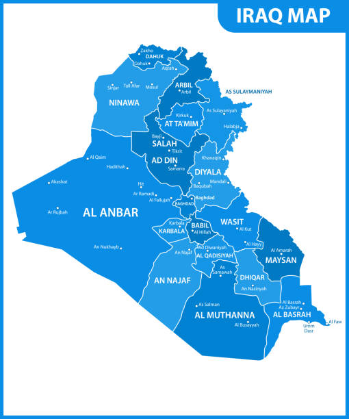
Iraq administrative and political vector map

Syria Map - Vintage High Detailed Vector Illustration

Turkey and Syria region, political map. Geographic area of the peninsula Anatolia, with neighbouring and surrounding countries. Map with capitals, largest cities, and most important rivers and lakes. Reference: University of Texas Libraries http://www.lib.utexas.edu/maps/middle_east_and_asia/turkey_physio-2006.jpg

Highly detailed vector map of Iraq.

Highly detailed physical map of the Iraq,in vector format,with all the relief forms,regions and big cities.

White map of Iraq isolated on a trendy color, a bright red background and with a dropshadow. Vector Illustration (EPS file, well layered and grouped). Easy to edit, manipulate, resize or colorize. Vector and Jpeg file of different sizes.

Iraq Map with flag isolated on white. Vector illustration.

Vector illustration of a map of Iraq. PDF file is included.
Political map of the Republic of Iraq with the most important cities marked in gray and blue tones. Vector image
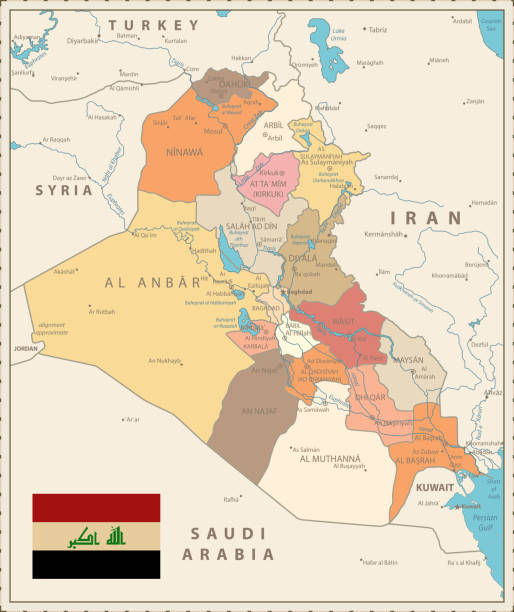
Administrative Map of Iraq Vintage Color with capital Baghdad, national borders, important cities, rivers and lakes.

Detailed, Hand Traced map of Iraq complete with Main Roads, Waterways and Territory Markers. ai(cs2&v8),hi-res jpeg and eps included

Iraq - highly detailed blue map. Vector illustration

Detailed map of Iraq with navigation icons.

Detailed map of Iraq.

Iraq Map White Color Map. Detailed vector illustration of Iraq map.


Map of Iraq for your own design. With space for your text and your background. Four maps included in the bundle: - One black map. - One blank map with only a thin black outline (in a line art style). - One mosaic map. - One white map with a thin black outline. The 4 maps are isolated on a blank background (for easy change background or texture).The layers are named to facilitate your customization. Vector Illustration (EPS10, well layered and grouped). Easy to edit, manipulate, resize or colorize.

3D map of Iraq isolated on a blank and gray background, with a dropshadow. Vector Illustration (EPS10, well layered and grouped). Easy to edit, manipulate, resize or colorize.
Highly detailed vector map Caucasus and Central Asia with states, capitals and big cities.

World globe map with the identication of Iraq. Map of Iraq. Iraq on grey political 3D globe. Asia map. Vector stock.

Map of Iraq in a trendy vintage style. Beautiful retro illustration with old textured paper and a black long shadow (colors used: blue, green, beige and black). Vector Illustration (EPS10, well layered and grouped). Easy to edit, manipulate, resize or colorize.
Highly detailed vector map of Caucasus and Central Asia with states, capitals and big cities.

3d verctor map of cities and roads in Asia. Iraq and its neighbors.

Map of Iraq in a trendy vintage style. Beautiful retro illustration of an antique map with light rays in the background and on old textured paper. Included: Realistic texture of an old parchment (colors used: sepia, beige, brown). Vector illustration (EPS10, well superimposed and grouped). Easy to edit, manipulate, resize or colorize.

Iraq Map and regions. Detailed map of Map and regions. Vector illustration.
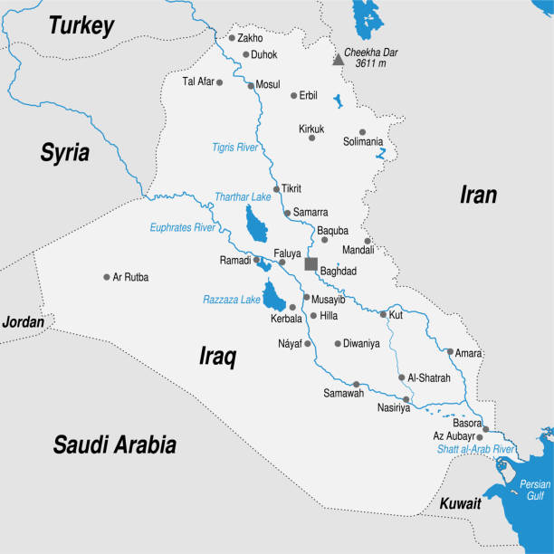
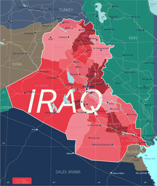
Iraq Road Map and map icons with capital Baghdad, national borders, important cities, roads, highways, railroads, rivers and lakes.


Syria - vintage map and flag - High Detailed Vector Illustration

Map of Iraq sketched and isolated on a blank background. The map is gray with a black outline. Vector Illustration (EPS file, well layered and grouped). Easy to edit, manipulate, resize or colorize. Vector and Jpeg file of different sizes.

Map of Iraq with national flag. Highly detailed editable map of Iraq, Western Asia country territory borders. Political or geographical design element vector illustration

Map of Iraq - Vintage Vector illustration


Republic of Iraq geometric polygonal, mosaic style maps collection. Bright abstract tessellation, low poly style, modern design. Republic of Iraq polygonal maps for your infographics or presentation.

Map of Iraq - Vector illustration

Iraq map with provinces (governorates) in various colours and cities: Baghdad, Mosul, Karbala, Najaf and others. Country information data table.

Map of Iraq with a retro style, a vintage effect on an old textured paper.

Map of Iraq - Vector illustration

Vector Australian Animals Map

World Countries vector maps series. Spiral fingerprint series

Republic of Iraq - vector map. Eps 8.

Iraq political map of administrative divisions - governorates and Kurdistan Region. 3D colorful vector map with name labels.

Map of Iraq cut out on a blank white paper with a blue background. Modern and trendy paper cutout effect. Vector Illustration (EPS file, well layered and grouped). Easy to edit, manipulate, resize or colorize. Vector and Jpeg file of different sizes.

Iraq - highly detailed black and white map. Vector illustration

vector illustration of Iraq map
Irak country detailed editable map with regions cities and towns, roads and railways, geographic sites. Vector EPS-10 file
Next