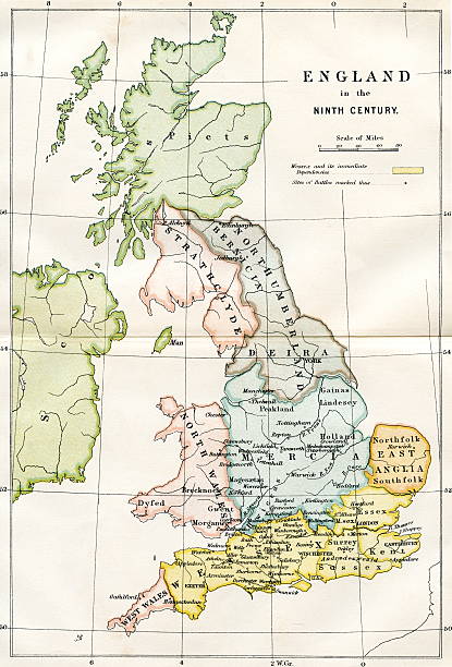
An engraved image showing a 9th century map of the kingdoms of Anglo Saxon Dark Age Britain taken from a Victorian book dated 1882 that is no longer in copyright
Browse 690+ england antique map stock illustrations and vector graphics available royalty-free, or start a new search to explore more great stock images and vector art.
An engraved image showing a 9th century map of the kingdoms of Anglo Saxon Dark Age Britain taken from a Victorian book dated 1882 that is no longer in copyright

Vintage engraving of a Antique map, Cambridge, Hertford, Essex, Suffolk, England 19th Century

Antique map of Britain. Published by the J.Tallis and Sons, London and New York, 1851. Photo by N. Staykov (2008)Click on thumbnails below for more UK maps:

Vintage illustration of Antique map of Britannia Antiqua, Ancient Britain. Atlas of Ancient Geography. By Samuel Butler

Tower of London in City of London England in 18th and 19th century

Old map of British Islands. Created by Laurence Nowell, published in England, 1564
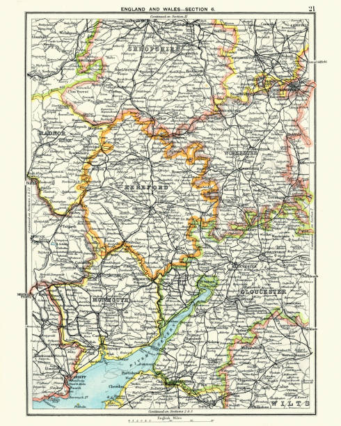
Antique map, Hereford, Worester, Monmouth, Gloucester, Shropshire, England and Wales 19th Century

You're looking at a crazy high quality scan of a beautifully preserved engraved steel plate print from the rare "New, Comprehensive, and Complete History of England" book by Edward Barnard, published in 1783. The delicate, informative, and detailed illustrations found inside encapsulated, in fascinating detail, moments of English History from the Roman era, right up to the Victorian.

Antique map of South East England, 1891

Very Rare, Beautifully Illustrated Antique Victorian Engraved Colored Map of The British Isles Antique Victorian Engraved Colored Map, 1899. Source: Original edition from my own archives. Copyright has expired on this artwork. Digitally restored.

City map of London with suburbs, capital of England and the United Kingdom. Lithograph, published in 1897.

Vintage illustration Plan of the Thames Embankment, Victorian London 1860s

Vintage Antquie Map of Manchester, Salfiord and Environs, England in 1880.

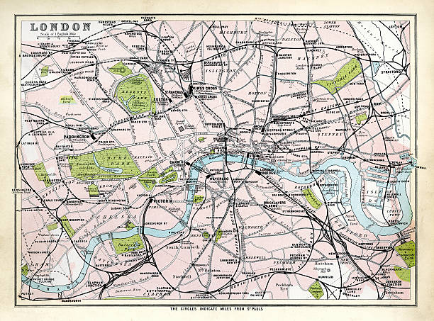
Vintage Antquie Map of London, England in 1880.

Comprehensive Geography by James Monteith - American Book Company 1882, 1889.
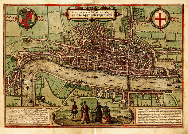
A medieval map of London, UK, from a XVII century original. Click on thumbnails below for more UK maps:

The World on Mercators ProjectionPrinted c1850
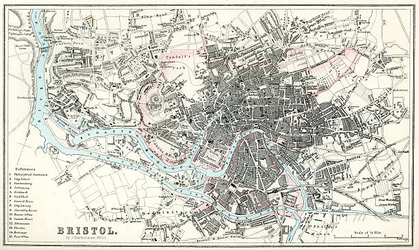
"Vintage map from 1880 of the streets and layout of Bristol, England++Inspector: Info about source material uploaded as property release++"
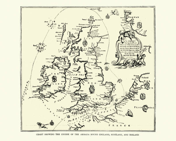
Vintage illustration of Map showing course of the Spanish Armada round England and Ireland
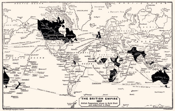
1897: The British Empire. British Possessions shown in Solid Black and underlined in Black. Vintage illustration circa late 19th century. Digital restoration by Pictore.

Vintage engraving of a Map of Victorian London and its environs, England, 1870s, 19th Century

"Vintage map of France in the 15th century, show the land under the control of the english during the Hundred Years War."

"Vintage engraving showing a Map of Ramsgate and Goodwin Sands, 19th Century"

Old XIX century engraving of the Tower of London.

ilustration of London city structure.near Waterloo Bridge and London Eye.Map data from© OpenStreetMap contributors.

Vintage engraving of Map of Plymouth Sound and the Breakwater, Victorian 19th Century
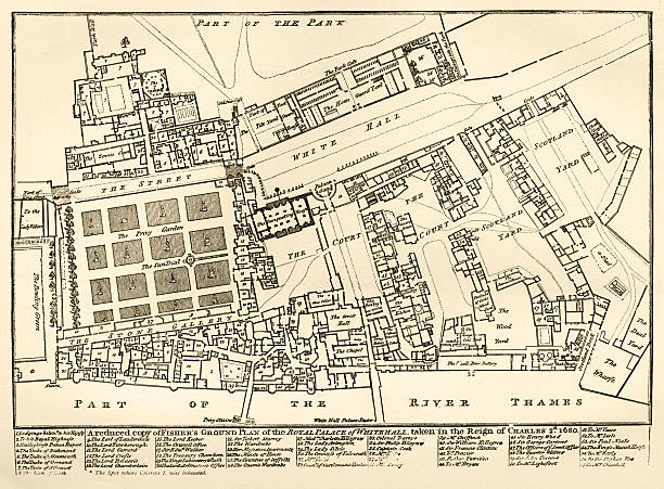
A ground plan of the old Royal Palace of Whitehall beside the River Thames in London. The Palace was an enormous collection of buildings and courtyards which was the main home of British monarchs until 1698 when much of the Palace was destroyed by fire. This plan was drawn up in 1680, during the reign of King Charles II. From “Old & New London” by Walter Thornbury and Edward Walford, published in parts by Cassell & Co, London from 1873-1888. These illustrations are from parts 30-35 inclusive.

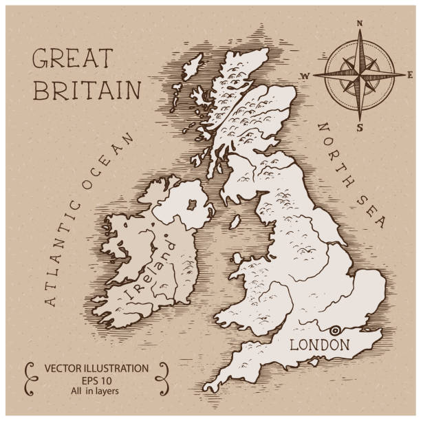
Map of United Kingdom in a trendy vintage style. Beautiful retro illustration with old textured paper and light rays in the background (colors used: blue, green, beige and black for the outline). Vector Illustration (EPS10, well layered and grouped). Easy to edit, manipulate, resize or colorize.

Engraving black and white - Advance Geography Redway and Hinman - Ohio Ed 1898

Map of America Greenland Ireland and Great Britain 1570 by Sigur Stephanius 1570 North Atlantic map from the Icelandic geographer Sigurd Stephanius, showing part of western Norway ( Norvegia ), Britain ( Britannia ), Ireland ( Ir Land ), Orkney Islands ( Orcades ), Shetland Islands ( Hetland ), Faroe ( Fero ), Iceland, and Greenland ( Grönlandia ). On the map, Helluland, Markland, Skraeling's Land, and the promontory of Vineland are shown as part of Greenland. Original edition from my own archives Source : America 1892
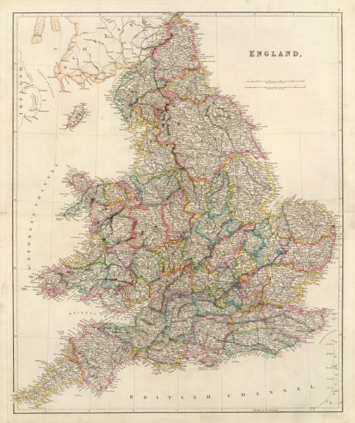
Antique map of EnglandSee more antique maps scanned from my collection of antique maps and engravings on iStockphoto:

City map of London, United Kingdom. Lithograph, published in 1877.

Map From 1883 Showing The British Empire Throughout The World.
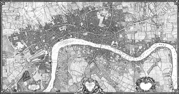
Scan of 1746 London map by John Rocque.More maps:

Map of United Kingdom in vintage style. Beautiful illustration of antique map on an old textured paper of sepia color. Old realistic parchment with a compass rose, lines indicating the different directions (North, South, East, West) and a frame used as scale of measurement.Vector Illustration (EPS10, well layered and grouped). Easy to edit, manipulate, resize or colorize. Please do not hesitate to contact me if you have any questions, or need to customise the illustration. http://www.istockphoto.com/portfolio/bgblue
Antique map of London, England, 1891
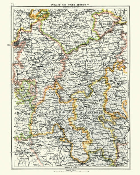
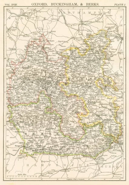
Vintage engraving of a Antique map, Leicester, Warwick, Northampton, Oxford, Buckingham. England 19th Century

A vintage-style map of Massachusetts with freeways, highways and major cities. Shoreline, lakes and rivers are very detailed. Includes an EPS and JPG of the map without roads and cities. Texture, compass, cities, etc. are on separate layers for easy removal or changes.

Map of United Kingdom in a trendy vintage style. Beautiful retro illustration with old textured paper and a black long shadow (colors used: blue, green, beige and black). Vector Illustration (EPS10, well layered and grouped). Easy to edit, manipulate, resize or colorize.
Encyclopedia Britannica 9th Edition New York Charles Scribners and Sons 1885 Vol XVIII

An original Antique Plate scan from the National Encyclopaedia: A Dictionary of Universal Knowledge. Published by William Mackenzie in 1880.

An antique stylized European abstract featuring 5 popular landmarks, with a textured paper effect.

Vintage engraving of Map of Leeds, Wesy Yorkshire, England 19th Century, 1878
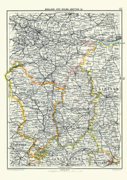
Vintage engraving of a Antique map, West Yorkshire, Derby, Nottingham, Lincoln, Stafford, Leicester, Rutland, England. 19th Century

Very Rare, Beautifully Illustrated Antique Engraving of Captain James Cook, English Victorian Engraving, 1840. Source: Original edition from my own archives. Copyright has expired on this artwork. Digitally restored.

Isle of Wight old map ans southern England. By Baptista Boazio, published in England, 1591.

Vintage engraving of a Map of Anglo-Saxon Kingdoms and the Danelaw, 9th Century

"Medieval map of Great Britain and Ireland, published more than 300 years agoClick on thumbnails below for more UK maps:"
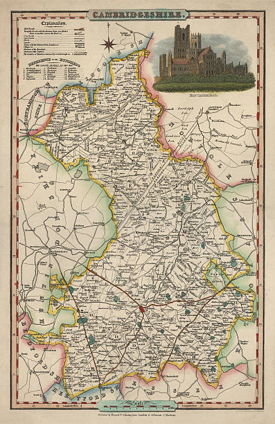
An antique map of Cambridgeshire 1840. James Pigot (1794-1842) showing the whole county and all it's major towns and cities.Pigot started as an engraver for Dean's Manchester Directory, but later set up his own business publishing the London and Provincial New Commercial Directory,

Vintage Antquie Map of the Bristol Channel, 1880. The Bristol Channel is a major inlet in the island of Great Britain, separating South Wales from Devon and Somerset in South West England. It extends from the lower estuary of the River Severn to the North Atlantic Ocean.

map/plan of the inner city of London from 1899
© 2025 iStockphoto LP. The iStock design is a trademark of iStockphoto LP. Browse millions of high-quality stock photos, illustrations, and videos.
Do Not Sell or Share