
Hawaii Island Map https://maps.lib.utexas.edu/maps/imw/txu-oclc-6654394-ne-nf-4.jpg https://maps.lib.utexas.edu/maps/world_maps/world_physical_2015.pdfHawaii Island Map
Browse 70+ kahoolawe stock illustrations and vector graphics available royalty-free, or search for molokini to find more great stock images and vector art.
Hawaii Island Map https://maps.lib.utexas.edu/maps/imw/txu-oclc-6654394-ne-nf-4.jpg https://maps.lib.utexas.edu/maps/world_maps/world_physical_2015.pdfHawaii Island Map

Hawaii map cute cartoon doodle. Hand drawn illustration of Hawaiian islands in simple vector style.

Hawaii Islands line art map - red, blue and white on black background

Hawaii Island Map https://maps.lib.utexas.edu/maps/imw/txu-oclc-6654394-ne-nf-4.jpg https://maps.lib.utexas.edu/maps/world_maps/world_physical_2015.pdfHawaii Island Map
United States, Maui city isolated skyline vector illustration, travel landmark
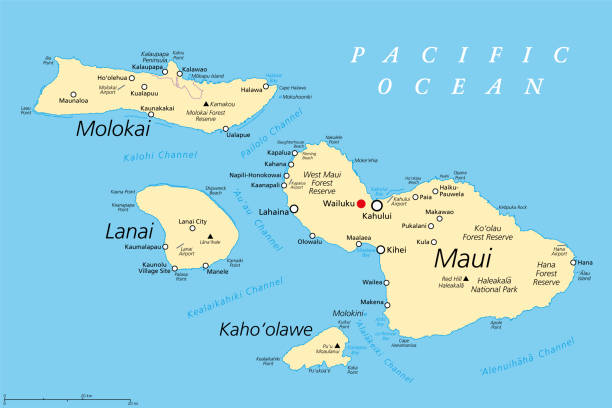
Maui County in the U.S. state Hawaii, political map, with Wailuku as seat. Consisting of the islands of Maui, Lanai, Molokai, Kahoolawe and Molokini. With Kalawao County on the north coast of Molokai.

Maui, Hawaii, gray political map with capital Wailuku. Part of Hawaiian Islands and Hawaii, a state of the United States in North Pacific Ocean. With unpopulated island Kahoolawe. Illustration. Vector

High detailed State of Hawaii map with navigation icons.

A highly detailed vector map of Honolulu, Hawaii with a multicoloured green hand painted watercolour texture. Map is isolated on a white background. "Honolulu" stylized text is added overtop with a star to indicate the location of the capital city.

Vector Cartoon map of Hawaii https://maps.lib.utexas.edu/maps/world_maps/world_physical_2015.pdf https://maps.lib.utexas.edu/maps/imw/txu-oclc-6654394-ne-nf-4.jpg


