The map is accurately prepared by a map expert.
Browse 240+ charleston-map stock illustrations and vector graphics available royalty-free, or start a new search to explore more great stock images and vector art.

vector illustration of South Carolina map

South Carolina map with text. South Carolina state map. Design for poster, banner, t-shirt, tee. South Carolina silhouette state. Vector outline Isolated black illustratuon on a white background.

Downloadable county map of Florida state of United States of America. The map is accurately prepared by a map expert.

Hilton Head detailed editable map with with, geographic sites, roads and streets. Vector EPS-10 file, trending color scheme

South Carolina, state of USA - solid black silhouette map of country area. Simple flat vector illustration.

South Carolina - flat collection of US states flags. Flags of twelve flat icons of various shapes. Set of vector illustrations

Hand painted water color graphic sketch, cut out clipart elements for design.

South Carolina vector grey dot outline triangle map

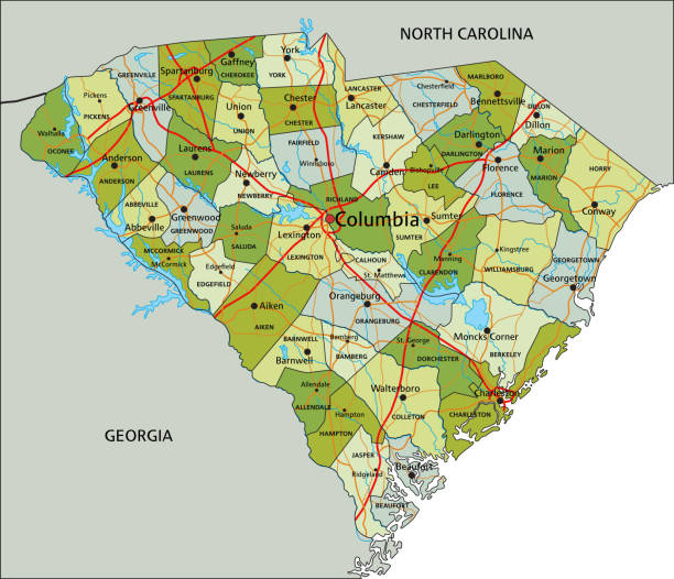
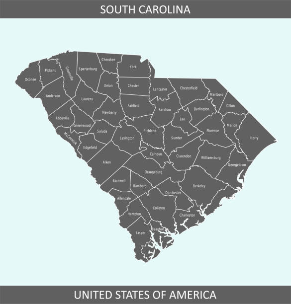
Highly detailed downloadable and printable county map of South Carolina state of United States of America for web banner, mobile, smartphone, iPhone, iPad applications and educational use. The map is accurately prepared by a map expert.

vector illustration of South Carolina map

South Carolina triangle graphic grey and silver vector perspective polygonal map

vector illustration of South Carolina map with American flag

South Carolina vector map. High detailed illustration. Country of the United States of America. Flat style. Vector illustration

The map is accurately prepared by a map expert.

Printable counties map of South Carolina state of United States of America. The map is accurately prepared by a map expert.

North Charleston SC City Vector Road Map Blue Text. All source data is in the public domain. U.S. Census Bureau Census Tiger. Used Layers: areawater, linearwater, roads.

Printable counties map of Florida state of United States of America. The map is accurately prepared by a map expert.
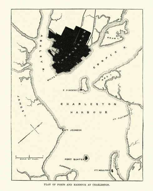
Vintage engraving of Plan of Forts and Harbour at Charlestown, South Carolina, 1860s, 19th Century

Downloadable county map of South Carolina state of United States of America. The map is accurately prepared by a map expert.

Vector of South Carolina state of the United States with counties map

vector illustration of South Carolina map

Minimalist West Virginia state outline vector on a sleek black background. Perfect for graphic design, maps, educational materials, and digital projects. Clean white design emphasizes the state’s shape, ideal for print, web, and branding purposes.
The map is accurately prepared by a map expert.

South Carolina, state of USA - solid black outline map of country area. Simple flat vector illustration.

South Carolina with love. Graphic design heart with map inside

vector illustration of South Carolina map

The map is accurately prepared by a map expert.

Highly detailed downloadable and printable counties map of South Carolina state of United States of America for web banner, mobile, smartphone, iPhone, iPad applications and educational use. The map is accurately prepared by a map expert.
Greenville hand drawn modern brush lettering. Vector illustration logo text for webpage, print and advertising

Vintage engraving of Map of Charleston, 18th Century

Map of the Battle of Sullivan's Island during the American Revolutionary War at Charleston, South Carolina, USA (circa 1776). Vintage etching circa 19th century.

South Carolina black vector outline polygonal triangle map

South Carolina US State Vector Road Map Grey. All source data is in the public domain. Roads, Water, Regions, Urban Areas: Made with Natural Earth. https://www.naturalearthdata.com/downloads/10m-physical-vectors/ https://www.naturalearthdata.com/downloads/10m-cultural-vectors/

vector illustration of South Carolina map

South Carolina (United States of America) - map of coffee bean, South Carolina map made of coffee beans,

South Carolina (United States of America) - map of coffee bean, South Carolina map made of coffee beans,

Map of Charleston County - South Carolina, in a trendy vintage style. Beautiful retro illustration with old textured paper and light rays in the background (colors used: blue, green, beige and black for the outline). Vector Illustration (EPS file, well layered and grouped). Easy to edit, manipulate, resize or colorize. Vector and Jpeg file of different sizes.

vector illustration of South Carolina map

South Carolina State on USA Map. South Carolina flag and map. US States.

vector illustration of South Carolina maps