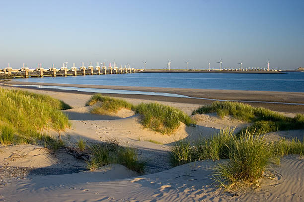
Dutch Oosterscheldedam. This is a waterwork that can be opened or closed. It is only closed during heavy storms at high tide. It is part of the dutch deltaworks. The largest watermanagement project in the world.....
Browse 1,700+ eastern scheldt stock photos and images available, or start a new search to explore more stock photos and images.
Dutch Oosterscheldedam. This is a waterwork that can be opened or closed. It is only closed during heavy storms at high tide. It is part of the dutch deltaworks. The largest watermanagement project in the world.....
Oosterschelde flood barrier with windmills in the Netherlands at the Northern Sea taken from above with a drone

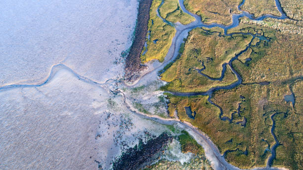
Nature reserve "Koudekerkse Inlage", Oosterschelde NP, Schouwen-Duiveland, Zeeland, Netherlands

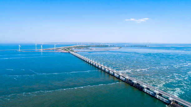
The Oosterschelde dam in Zeeland in The Netherlands. Part of the Deltaworks protection system, established after the big flood of 1953.

This area is a popular site for both nature lovers and landscape photographers. The tower on the horizon is the so-called Plompetoren. It is 23 meters high and is the only structure that remains from the former village of Koudekerke which disappeared in the Oosterschelde in the 16th cent.

A vertical low angle shot of a sunset over the ocean in Storm surge barrier, Zeeland, The Netherlands

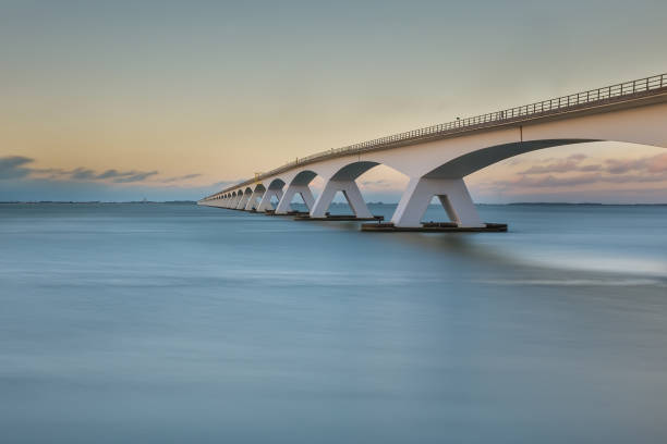
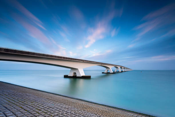
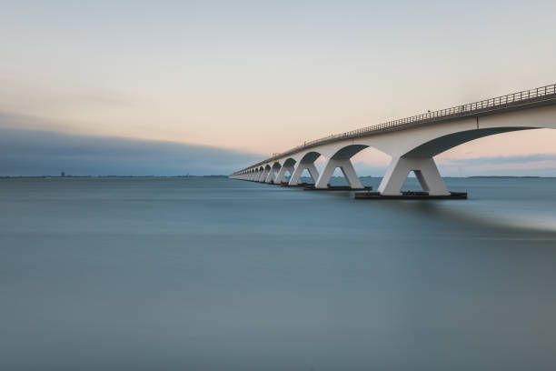
The Zeelandbrug over the oosterschelde connects the dutch islands Noord-Beveland and Schouwen-Duiveland, in Zeeland. The length is 5km. Long Exposure on an overcast day.

Dutch Oosterscheldedam. This is a waterwork that can be opened or closed. It is only closed during heavy storms at high tide. It is part of the dutch deltaworks. The largest watermanagement project in the world.....

The Oosterscheldedam or Eastern Scheldt storm surge barrier in the province of Zeeland in The Netherlands. The storm surge barrier is part of the Deltaworks protection system, established after the big flood of 1953.

Man adjusting his gear before a dive, Zeeland,the Netherlands.

Eastern Scheldt Bridge from sailboat, Eastern Scheldt, Zeeland, Netherlands

Wind power: sailing ships on the Eastern Scheldt estuary and wind turbines on the storm surge barrier, Netherlands

The Zeelandbrug (Zeeland Bridge) in the Dutch province of Zeeland, photographed at sunrise. At the time of construction in the sixties the Zeeland bridge was the longest bridge in Europe. These days it's still the longest bridge of the Netherlands.
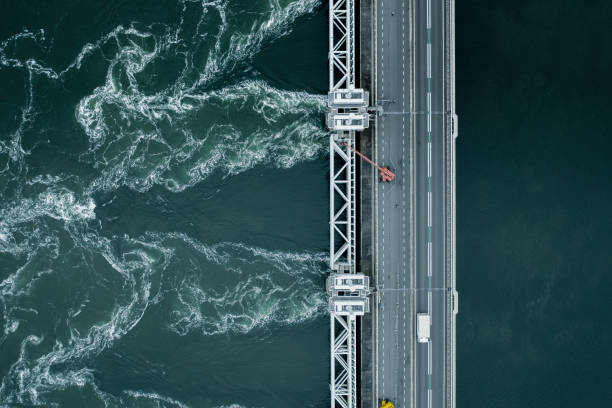
A storm surge barrier in the Netherlands venting water to ease flooding risks to the country after heavy rains and high tides

zeeland bridge under blue sky in the netherlands

Animal collection, group of big sea seals resting on sandy beach during low tide in Oosterschelde, Zeeland, Netherlands in june

Lonely cyclist riding on the dyke along the Eastern Scheldt in Yerseke. Picture was taken from a nature reserve Yerseke Moer.
A storm surge barrier in the Netherlands venting water to ease flooding risks to the country after heavy rains and high tides

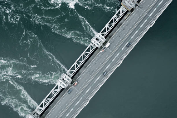
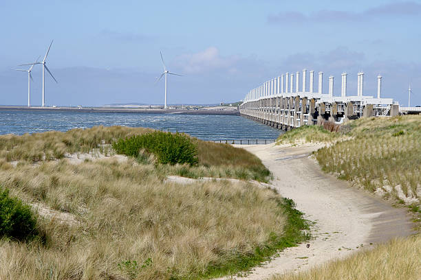
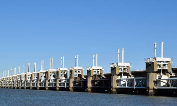
The Eastern Scheldt storm surge barrier known locally as Oosterscheldekering is a floodwater storm protection barrier, shielding the Netherlands from storm surges by closing gates and restricting water flow, holding back the sea water in the event of rising sea levels.

Bridge into nowhere in black and white. Zeelandbrug over the Oosterschelde connecting Noord-Beveland to Schouwen-Duiveland. In the distance Zierikzee at the end of the 5 kilometer long bridge.

The Zeelandbrug on a cloudy day. The sky is purple and blue and is reflected in the water.
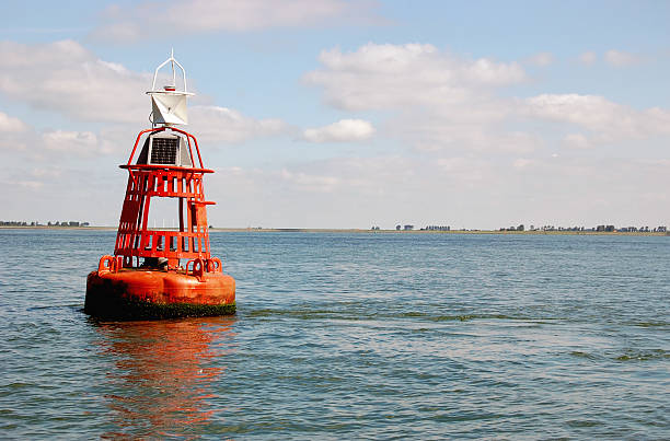
Buoy marking the navigable depth in the East Scheldt,the Netherlands.
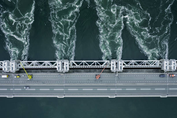
A storm surge barrier in the Netherlands venting water to ease flooding risks to the country after heavy rains and high tides

"The Zeelandbrug (Zeeland Bridge) in the Dutch province of Zeeland, photographed at sunrise. At the time of construction in the sixties the Zeeland bridge was the longest bridge in Europe. These days it's still the longest bridge of the Netherlands. A seamlessly stitched panoramic image."

A storm surge barrier in the Netherlands venting water to ease flooding risks to the country after heavy rains and high tides

Highly detailed vector map of the Netherlands. File was created on July 9, 2011. The colors in the .eps-file are ready for print (CMYK). Included files: EPS (v8) and Hi-Res JPG.
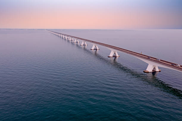
Aerial view on the longest bridge in the Netherlands, Zealand bridge spans Eastern Scheldt estuary, connects islands Schouwen-Duiveland and Noord-Beveland in province of Zeeland, water of Oesterschelde in the Netherlands
Long exposure photo of Zeeland bridge at sunset, Sunday 7 August, Zierikzee, the Netherlands

"The Zeelandbrug (Zeeland Bridge) in the Dutch province of Zeeland, photographed at sunrise. At the time of construction in the 60s the Zeeland bridge was the longest bridge in Europe. These days it's still the longest bridge in the Netherlands."

Backlit image of a sand beach along a pier in the Oosterschelde estuary in the Dutch province of Zeeland near the village of Bruinisse. In the background, unidentified people are looking for cockles.

The Eastern Scheldt storm surge barrier known locally as Oosterscheldekering is a floodwater storm protection barrier, shielding the Netherlands from storm surges by closing gates and restricting water flow, holding back the sea water in the event of rising sea levels.

Animal collection, young and old sheeps grazing on green meadows on Schouwen-Duiveland, Zeeland, Netherlands along Oosterschelde

The Eastern Scheldt storm surge barrier known locally as Oosterscheldekering is a floodwater storm protection barrier, shielding the Netherlands from storm surges by closing gates and restricting water flow, holding back the sea water in the event of rising sea levels.

Eastern Scheldt storm surge barrier (Oosterscheldekering) in the Dutch province of Zeeland.

"The Zeelandbrug (Zeeland Bridge) in the Dutch province of Zeeland, photographed at sunrise. At the time of construction in the 60s the Zeeland bridge was the longest bridge in Europe. These days it's still the longest bridge in the Netherlands."

This aerial drone photo shows the Oosterscheldekering in Zeeland. This Eastern Scheldt storm surge barrier protects the land behind this sea wall when a storm and high tide hits the coastline.

The Eastern Scheldt storm surge barrier known locally as Oosterscheldekering is a floodwater storm protection barrier, shielding the Netherlands from storm surges by closing gates and restricting water flow, holding back the sea water in the event of rising sea levels.

Animal collection, group of big sea seals resting on sandy beach during low tide in Oosterschelde, Zeeland, Netherlands in june

A storm surge barrier in the Netherlands venting water to ease flooding risks to the country after heavy rains and high tides

The Oosterschelde dam in Zeeland in The Netherlands. Part of the Deltaworks protection system, established after the big flood of 1953.
Dutch 9 kilometer long storm surge barrier to protect The Netherlands from the North Sea

The Eastern Scheldt storm surge barrier known locally as Oosterscheldekering is a floodwater storm protection barrier, shielding the Netherlands from storm surges by closing gates and restricting water flow, holding back the sea water in the event of rising sea levels.

Oysters growing systems, keeping oysters in concrete oyster pits, where they are stored in crates in continuously refreshed water, fresh oysters ready for sale and consumption on farm in Yerseke, Zeeland, Netherlands

Oosterscheldekering in the province of Zeeland. Protect Holland against flood by stormy wheather. Eastern Scheldt barrier in the province of Zeeland that protects the Netherlands against high water during storms. Seen from the Pijlerdam on the Neeltje Jans work island.
Zeelandbrug (Zeeland Bridge) in the Dutch province of Zeeland, the longest bridge of the Netherlands, in the morning against a blue sky

Part of the Zeeland bridge over the Oosterschelde near Colijnsplaat in Zeeland, The Netherlands

aerial view on the Zeelandbrug (Zeeland Bridge) in the Dutch province of Zeeland, the longest bridge of the Netherlands

Colour image of the Zeeland bridge in The Netherlands at dawn with cloudy skies and rising sun.

View from a dyke along the Oosterschelde on the famous Dutch Zeeland Bridge
Eastern Scheldt barrier in Zeeland as part of the Delta Works, created to protect the Netherlands against flooding during spring tides

Animal collection, young and old sheeps grazing on green meadows on Schouwen-Duiveland, Zeeland, Netherlands along Oosterschelde

Big colony of sea seals resting on yellow sandy island during low tide near Renesse beach, Zeeland, Netherlands

Animal collection, group of big sea seals resting on sandy beach during low tide in Oosterschelde, Zeeland, Netherlands in june

View across the sea to the Eastern Scheldt Storm Surge Barrier in Zeeland with a stormy sky, dramatic sunlight with sand dunes, grass and beach in foreground. Oosterscheldekering during winter season in Holland in the Netherlands in Europe. Important in the environment for sea levels with global warming with climate change.

Flock of cormorants flying over a wind turbine park in the Eastern Scheldt nature reserve, Netherlands
Long exposure photo of Zeeland bridge at sunset, Sunday 7 August, Zierikzee, the Netherlands
© 2024 iStockphoto LP. The iStock design is a trademark of iStockphoto LP. Browse millions of high-quality stock photos, illustrations, and videos.
Do Not Sell or Share