
Vintage engraving from 1861 showing the Plan of the Blockade of Boston during the American Revolutionary War.
Browse 1,800+ old military map stock photos and images available, or start a new search to explore more stock photos and images.
Vintage engraving from 1861 showing the Plan of the Blockade of Boston during the American Revolutionary War.

Vintage engraving of a scene from the Franco Prussian War. plan of the Battle of Amiens

Vector banner with skull in pirate hat, crossed pistols and words Pirates Dead Island, Born to be free. Illustration on the theme of travel, military adventure and battles on the background of old map

Old Warden, Bedfordshire, England - July 08, 2016: German Luftwaffe Fiesler Storm WW2 reconnaissance airplane coming in to land.

Empty treasure map with hand drawn frame, weapon, pirates flag. Vector background with pistols, sabers, old map and place for text. Vintage illustration on the theme of travel, adventure and discovery

Vintage illustration of Plan of the Battle of Abu Klea, Mahdist war, 19th Century. The Battle of Abu Klea, or the Battle of Abu Tulayh took place between the dates of 16 and 18 January 1885, at Abu Klea, Sudan, between the British Desert Column and Mahdist forces encamped near Abu Klea.

Military army vehicle tank on tracks

Three military tanks stand on the field with muzzles raised in the sky

Vintage illustration of Plan of Battle of Battle of Majuba Hill, First Boer War. The Battle of Majuba Hill (near Volksrust, South Africa) on 27 February 1881 was the final and decisive battle of the First Boer War. It was a resounding victory for the Boers.

vector of world war pilot

A variety of old Nautical and Navigational instruments are shown against a warm background and map which is several hundred years old. Copyspace Considered

child looks curiously at the rusty unexploded bomb lying on the needles in a pine forest

Old cartridges on a background of a card of the Europe

Vintage engraving from 1863 of a map of Bull Run and its environs at the time of the American Civil War. The First Battle of Bull Run, also known as the First Battle of Manassas (the name used by Confederate forces), was fought on July 21, 1861, in Prince William County, Virginia, near the City of Manassas. It was the first major land battle of the American Civil War. And resulted in a Confederate victory.

View on a desk in a old military office. A stack of old letters tied with laces, typewriter old yellow paper, binoculars, ash tray lying on a map, telephone. Shallow depth of field.

antique map postcard of the Far East in early 1900s in Italian, discribed the situation of the War between Russia and Japan in 1904-0905. Publusher unknown.

Vintage Picture, Map of the Naval campaign of 1898 in the West Indies, Spanish–American War, 1890s 19th Century MIlitary History

"Vintage engraving from 1863 of a map of the Battle of Fort Donelson which was fought from February 11 to February 16, 1862, in the Western Theater of the American Civil War. The capture of the fort by Union forces opened the Cumberland River as an avenue for the invasion of the South."

City map military navigation GPS overlay. Top view, view from above with military classic oldschool green monochrome ceber overlay. Simple realistic map design of town.

Vintage engraving showing a plan of the Battle of Bannockburn. The Battle of Bannockburn (24 June 1314) was a significant Scottish victory in the Wars of Scottish Independence.

Antique Canadian classroom map from 1920, depicting Constantinople (modern day Istanbul) and its location in northern Turkey.

Map of Civil War Map of Operations in the West, United States History. Illustration published in First Lessons in Our Country’s History by William Swinton, A.M. (Ivison, Blakeman, Taylor, & Company, New York and Chicago) in 1872.

Vintage engraving of a scene fro the Franco Prussian War. Plan of Metz and French entrenched camp

Topographic map of the Battle of Waterloo, Belgium. The defeat of the French army under the command of Napoleon Bonaparte on 18 June 1815 marked the end of the Napoleonic Wars. Wood engraving, published in 1897.

Vintage engraving of Plan of Battle of Guilford Court House, American Revolutionary War. The Battle of Guilford Court House was fought on March 15, 1781, during the American Revolutionary War, at a site which is now in Greensboro, the seat of Guilford County, North Carolina.

Very Rare, Beautifully Illustrated Antique Engraving of Captain James Cook, English Victorian Engraving, 1840. Source: Original edition from my own archives. Copyright has expired on this artwork. Digitally restored.

Minimal outdoors survival gear compass navigation knife and cutting axe on the tree stump

Vintage engraving of a plan of the Siege of Savannah or the Second Battle of Savannah was an encounter of the American Revolutionary War (1775-1783), in 1779.

Tropical traveler's cork helmet lying on an old scroll or map next to a spyglass isolated on white background

detail of an old and worn military map

Headphones and an old military radio station

Foldable lid military grade compassisolated on white background with clipping path.

Vintage engraving of Plan of the Battle of Sơn Tay, French forces attacking the Black Flag Arm, Tonkin (northern Vietnam). The Graphic, 1884

Chest and musket gun vector sketch, vintage map elements of pirate treasures. Map of treasure island with icon of chest with golden coin and pistol guns of sailor or corsair and filibuster captain

North and South Carolinas 1780-1781, USA, map during the American Revolution. Illustration published 1895. Copyright expired; artwork is in Public Domain.

Vintage illustration Battle plan of Bombardment of Alexandria in Egypt by the British Mediterranean Fleet took place on 11–13 July 1882, 19th Century
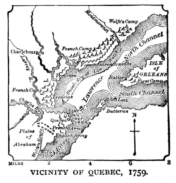
Quebec, Canada map, 1759. Illustration published 1895. Copyright expired; artwork is in Public Domain.

Map of military battles between the French and Native Americans against the British and American Colonists in 1754–1763. Illustration published in The New Eclectic History of the United States by M. E. Thalheimer (American Book Company; New York, Cincinnati, and Chicago) in 1881 and 1890. Copyright expired; artwork is in Public Domain.

vector map of the alexander the great empire for your design
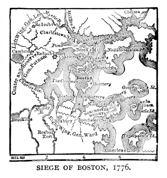
Map of Bunker Hill battle during siege of Boston, Massachusetts during American Revolutionary War, June 17, 1775. Illustration published 1895. Original edition is from my own archives. Copyright has expired and is in Public Domain.
Compass wind rose, vintage map with north star arrow, vector nautical travel old icon. Marine navigation and sailing adventure compass with wind rose direction in east and west, cartography symbol

Map of Confederate Army Raids in Maryland. Illustration engraving published 1895. Original edition is from my own archives. Copyright has expired and is in Public Domain.

View from above. Vector illustration.

Heavy armor tank with dust from under the caterpillars in the field of battle

Illustration of a Battle of Blenheim , fought on 13 August 1704, was a major battle of the War of the Spanish Succession

Vector background with place for text, cannon and old map. Vintage illustration on the theme of travel, adventure and discovery. Empty treasure map with hand drawn frame, gun, cores and pirates flag

close-up of World War I barbed wire abandoned in the Dolomites of Cortina D'ampezzo in Belluno, Veneto, Italy

Vintage still life with compass, sextant, spyglass, saber. Pirates gold coins treasure

Vintage illustration of Plan of the Battle of Hasheen March 20th 1885, Mahdist War

Slavin is a memorial monument and military cemetery of Soviet soldiers who fell during the World War two while liberating the city in April 1945


