Peruvian People Pictures, Images and Stock Photos
Browse 47,700+ peruvian people stock photos and images available, or search for peruvian culture or peruvian ethnicity to find more great stock photos and pictures.
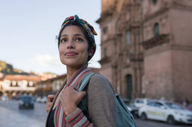
Portrait of a happy woman sightseeing walking around Cusco by the Cathedral and smiling - travel destinations concepts
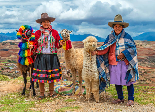
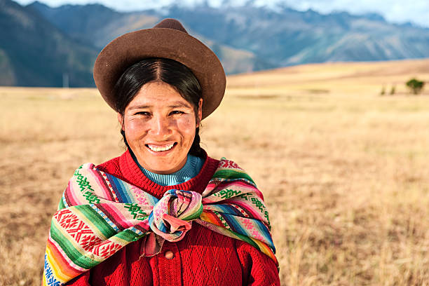
A rural portrait of Quechua Indigenous Women in traditional clothes with their domestic animals, two llama and one alpaca, Sacred Valley of the Inca, Cusco, Peru.
The Sacred Valley of the Incas or Urubamba Valley is a valley in the Andes of Peru, close to the Inca capital of Cusco and below the ancient sacred city of Machu Picchu. The valley is generally understood to include everything between Pisac and Ollantaytambo, parallel to the Urubamba River, or Vilcanota River or Wilcamayu, as this Sacred river is called when passing through the valley. It is fed by numerous rivers which descend through adjoining valleys and gorges, and contains numerous archaeological remains and villages. The valley was appreciated by the Incas due to its special geographical and climatic qualities. It was one of the empire's main points for the extraction of natural wealth, and the best place for maize production in Peru.http://bem.2be.pl/IS/peru_380.jpg
Chivay is a town in the Colca valley, capital of the Caylloma province in the Arequipa region, Peru. Located at about 12,000 ft above sea level, it lies upstream of the renowned Colca Canyon. It has a central town square and an active market. Ten kilometers to the east, and 1,500 meters above the town of Chivay lies the Chivay obsidian source. Thermal springs are located 3 km from town, a number of heated pools have been constructed. A stone "Inca" bridge crosses the Colca River ravine, just to the north of the town. The town is a popular staging point for tourists visiting Condor Cross or Cruz Del Condor, where condors can be seen catching thermal uplifts a few kilometers downstream.http://bem.2be.pl/IS/peru_380.jpg

Cusco, Peru - August 08, 2015: People selling and buying fruits at a market in the steets.
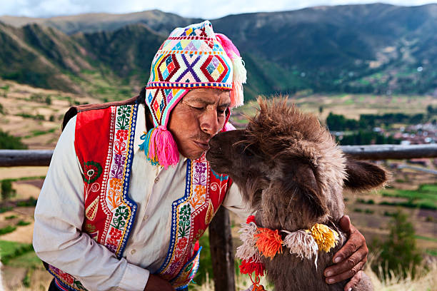
Peruvian man kissing llama near Pisac. The Sacred Valley of the Incas or Urubamba Valley is a valley in the Andes of Peru, close to the Inca capital of Cusco and below the ancient sacred city of Machu Picchu. The valley is generally understood to include everything between PÃsac and Ollantaytambo, parallel to the Urubamba River, or Vilcanota River or Wilcamayu, as this Sacred river is called when passing through the valley. It is fed by numerous rivers which descend through adjoining valleys and gorges, and contains numerous archaeological remains and villages. The valley was appreciated by the Incas due to its special geographical and climatic qualities. It was one of the empire's main points for the extraction of natural wealth, and the best place for maize production in Peru.
The Sacred Valley of the Incas or Urubamba Valley is a valley in the Andes of Peru, close to the Inca capital of Cusco and below the ancient sacred city of Machu Picchu. The valley is generally understood to include everything between Pisac and Ollantaytambo, parallel to the Urubamba River, or Vilcanota River or Wilcamayu, as this Sacred river is called when passing through the valley. It is fed by numerous rivers which descend through adjoining valleys and gorges, and contains numerous archaeological remains and villages. The valley was appreciated by the Incas due to its special geographical and climatic qualities. It was one of the empire's main points for the extraction of natural wealth, and the best place for maize production in Peru.http://bem.2be.pl/IS/peru_380.jpg

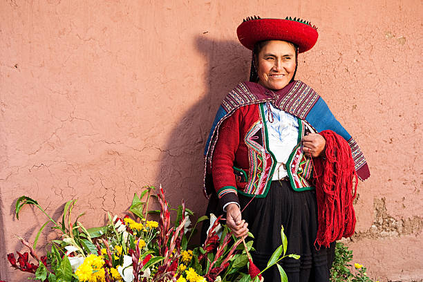
A close up of a woman weaving in Peru with bright traditional clothes.
Iquitos, Peru- Sep 26, 2018: Yagua Indians in his local costume. Latin America. Yagua, Nativa Yahuas Comunidad.

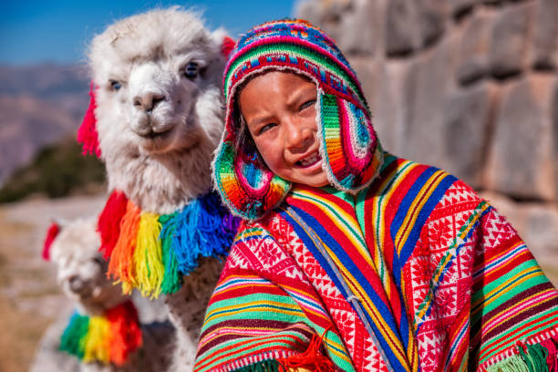
Cusco, Peru - February 10, 2018: Young woman with her little niece pose in a portrait with their typical costumes next to her little alpaca in a street in the historic center of Cusco
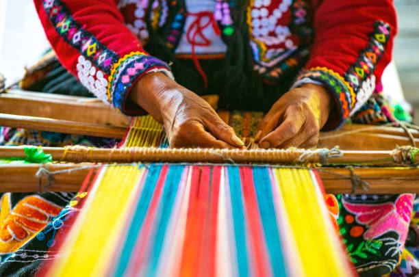
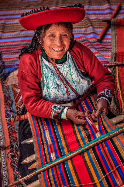
Peruvian indigenous Quechua woman weaving a textile with the traditional techniques in Cusco, Peru.


Uros are a pre-Incan people that live on forty-two self-fashioned floating island in Lake Titicaca Puno, Peru and Bolivia. They form three main groups: Uru-Chipayas, Uru-Muratos and the Uru-Iruitos. The latter are still located on the Bolivian side of Lake Titicaca and Desaguadero River. The Uros use bundles of dried totora reeds to make reed boats (balsas mats), and to make the islands themselves. The Uros islands at 3810 meters above sea level are just five kilometers west from Puno port.http://bem.2be.pl/IS/peru_380.jpg

Chivay is a town in the Colca valley, capital of the Caylloma province in the Arequipa region, Peru. Located at about 12,000 ft above sea level, it lies upstream of the renowned Colca Canyon. It has a central town square and an active market. Ten kilometers to the east, and 1,500 meters above the town of Chivay lies the Chivay obsidian source. Thermal springs are located 3 km from town, a number of heated pools have been constructed. A stone "Inca" bridge crosses the Colca River ravine, just to the north of the town. The town is a popular staging point for tourists visiting Condor Cross or Cruz Del Condor, where condors can be seen catching thermal uplifts a few kilometers downstream

Taquile is an island on the Peruvian side of Lake Titicaca 45 km offshore from the city of Puno. About 1,700 people live on the island, which is 5.5 by 1.6 km in size (maximum measurements), with an area of 5.72 km2. The highest point of the island is 4050 meters above sea level and the main village is at 3950 m. The inhabitants, known as Taquilenos, are southern Quechua speakers. Taquilenos run their society based on community collectivism and on the Inca moral code ama sua, ama llulla, ama qhilla, (Quechua for "do not steal, do not lie, do not be lazy"). The island is divided into six sectors or suyus for crop rotation purposes. The economy is based on fishing, terraced farming horticulture based on potato cultivation, and tourist-generated income from the approximately 40,000 tourists who visit each year.Taquilenos are known for their fine handwoven textiles and clothing, which are regarded as among the highest-quality handicrafts in Peru. Everyone on the island - children, women, and men - spins and weaves.http://bem.2be.pl/IS/peru_380.jpg

The Sacred Valley of the Incas or Urubamba Valley is a valley in the Andes of Peru, close to the Inca capital of Cusco and below the ancient sacred city of Machu Picchu. The valley is generally understood to include everything between Pisac and Ollantaytambo, parallel to the Urubamba River, or Vilcanota River or Wilcamayu, as this Sacred river is called when passing through the valley. It is fed by numerous rivers which descend through adjoining valleys and gorges, and contains numerous archaeological remains and villages. The valley was appreciated by the Incas due to its special geographical and climatic qualities. It was one of the empire's main points for the extraction of natural wealth, and the best place for maize production in Peru.http://bem.2be.pl/IS/peru_380.jpg

Peruvian woman sailing between Uros floating islands. Uros are a pre-Incan people that live on forty-two self-fashioned floating island in Lake Titicaca Puno, Peru and Bolivia. They form three main groups: Uru-Chipayas, Uru-Muratos and the Uru-Iruitos. The latter are still located on the Bolivian side of Lake Titicaca and Desaguadero River. The Uros use bundles of dried totora reeds to make reed boats (balsas mats), and to make the islands themselves. The Uros islands at 3810 meters above sea level are just five kilometers west from Puno port.

Uros are a pre-Incan people that live on forty-two self-fashioned floating island in Lake Titicaca Puno, Peru and Bolivia. They form three main groups: Uru-Chipayas, Uru-Muratos and the Uru-Iruitos. The latter are still located on the Bolivian side of Lake Titicaca and Desaguadero River. The Uros use bundles of dried totora reeds to make reed boats (balsas mats), and to make the islands themselves. The Uros islands at 3810 meters above sea level are just five kilometers west from Puno port.http://bem.2be.pl/IS/peru_380.jpg

The Sacred Valley of the Incas or Urubamba Valley is a valley in the Andes of Peru, close to the Inca capital of Cusco and below the ancient sacred city of Machu Picchu. The valley is generally understood to include everything between Pisac and Ollantaytambo, parallel to the Urubamba River, or Vilcanota River or Wilcamayu, as this Sacred river is called when passing through the valley. It is fed by numerous rivers which descend through adjoining valleys and gorges, and contains numerous archaeological remains and villages. The valley was appreciated by the Incas due to its special geographical and climatic qualities. It was one of the empire's main points for the extraction of natural wealth, and the best place for maize production in Peru.
"The Sacred Valley of the Incas or Urubamba Valley is a valley in the Andes of Peru, close to the Inca capital of Cusco and below the ancient sacred city of Machu Picchu. The valley is generally understood to include everything between P"

Friends making a Peruvian flag with their t-shirt

The Sacred Valley of the Incas or Urubamba Valley is a valley in the Andes of Peru, close to the Inca capital of Cusco and below the ancient sacred city of Machu Picchu. The valley is generally understood to include everything between Pisac and Ollantaytambo, parallel to the Urubamba River, or Vilcanota River or Wilcamayu, as this Sacred river is called when passing through the valley. It is fed by numerous rivers which descend through adjoining valleys and gorges, and contains numerous archaeological remains and villages. The valley was appreciated by the Incas due to its special geographical and climatic qualities. It was one of the empire's main points for the extraction of natural wealth, and the best place for maize production in Peru.http://bhphoto.pl/IS/peru_380.jpg
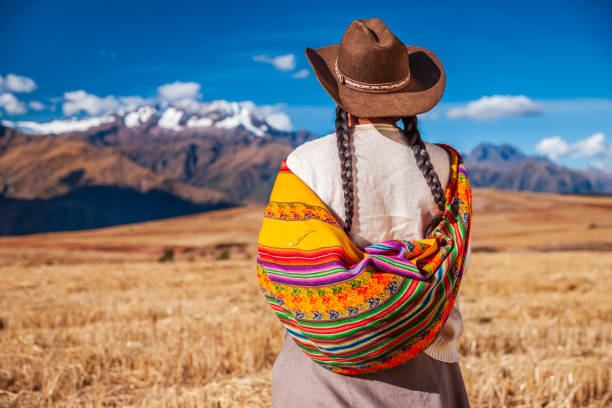
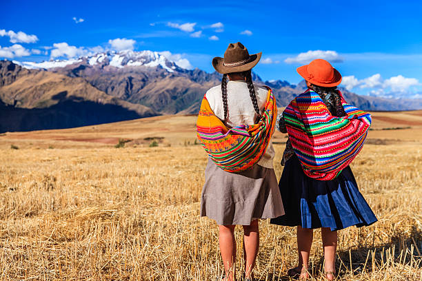
Peruvian woman in national clothing admiring view of Andes in The Sacred Valley. The Sacred Valley of the Incas or Urubamba Valley is a valley in the Andes of Peru, close to the Inca capital of Cusco and below the ancient sacred city of Machu Picchu.

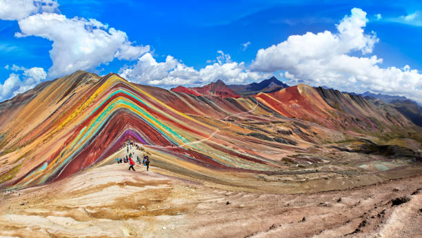
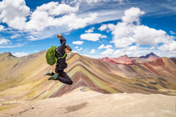
Unidentified tourists walking on the Rainbow Mountain (Vinicunca Montana de Siete Colores - Spanish) in Cusco, Peru.
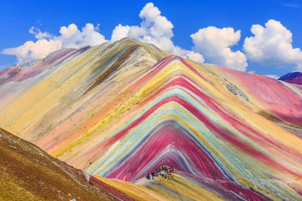
Vinicunca, Cusco Region, Peru. Montana de Siete Colores, or Rainbow Mountain.

Cusco, peru - October 21, 2016: Indigenous, wearing Peruvian tradicional clothings, with her llama

Lima, Peru - September 5, 2014: Jiron De La Union is the busiest shopping street in LIma. It is a pedestrian only street in the historic district of Lima. With hundreds of stores and historical churches and buildings, it makes it a prime destination for locals and tourists alike. Photo taken during the day and contains many people.

Emotion during soccer match

friendly person from Peru south America small business use digital tablet and internet for her small business morning organization.
"The Sacred Valley of the Incas or Urubamba Valley is a valley in the Andes of Peru, close to the Inca capital of Cusco and below the ancient sacred city of Machu Picchu. The valley is generally understood to include everything between P"

Uros are a pre-Incan people that live on forty-two self-fashioned floating island in Lake Titicaca Puno, Peru and Bolivia. They form three main groups: Uru-Chipayas, Uru-Muratos and the Uru-Iruitos. The latter are still located on the Bolivian side of Lake Titicaca and Desaguadero River. The Uros use bundles of dried totora reeds to make reed boats (balsas mats), and to make the islands themselves. The Uros islands at 3810 meters above sea level are just five kilometers west from Puno port.http://bem.2be.pl/IS/peru_380.jpg
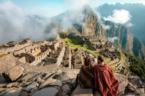
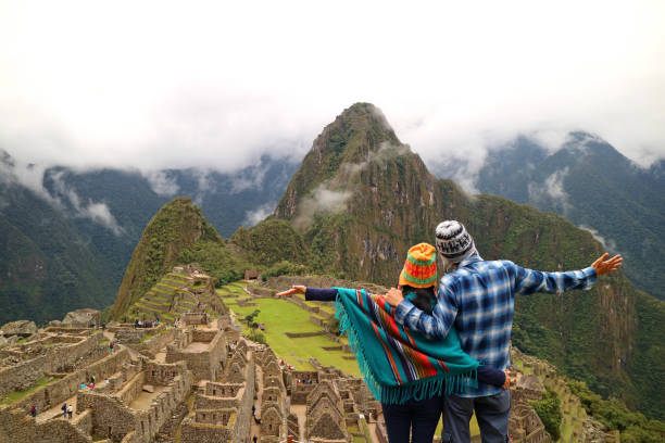
Couple dressed in ponchos watching the ruins of Machu Picchu

Cusco, Peru' - October 05 2017: Peruvian fans in Plaza de Armas waiting for the Argentina vs Peru' match, valid for qualifying for the 2018 World Cup in Russia.

Young peruvian man wearing a pink shirt stand with a coffee cup. Isolated over white background.
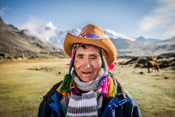
Indigenous man portrait living traditional life in the mountains.

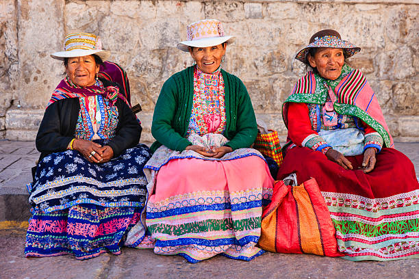
Peruvian women wearing national clothing waiting for a bus. Chivay is a town in the Colca valley, capital of the Caylloma province in the Arequipa region, Peru. Located at about 12,000 ft above sea level, it lies upstream of the renowned Colca Canyon. It has a central town square and an active market. Ten kilometers to the east, and 1,500 meters above the town of Chivay lies the Chivay obsidian source. Thermal springs are located 3 km from town, a number of heated pools have been constructed. A stone "Inca" bridge crosses the Colca River ravine, just to the north of the town. The town is a popular staging point for tourists visiting Condor Cross or Cruz Del Condor, where condors can be seen catching thermal uplifts a few kilometers downstream.http://bhphoto.pl/IS/peru_380.jpg

Peruvian woman sailing between Uros floating islands. Uros are a pre-Incan people that live on forty-two self-fashioned floating island in Lake Titicaca Puno, Peru and Bolivia. They form three main groups: Uru-Chipayas, Uru-Muratos and the Uru-Iruitos. The latter are still located on the Bolivian side of Lake Titicaca and Desaguadero River. The Uros use bundles of dried totora reeds to make reed boats (balsas mats), and to make the islands themselves. The Uros islands at 3810 meters above sea level are just five kilometers west from Puno port.
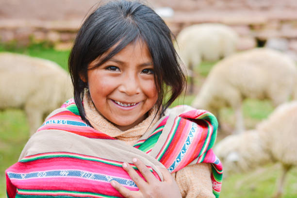
Happy native american girl wearing ethnic aymara cloth. Sheep on the background.

Peruvian dancers at the parade in Cusco. People in traditional clothes.

The Sacred Valley of the Incas or Urubamba Valley is a valley in the Andes of Peru, close to the Inca capital of Cusco and below the ancient sacred city of Machu Picchu. The valley is generally understood to include everything between Pisac and Ollantaytambo, parallel to the Urubamba River, or Vilcanota River or Wilcamayu, as this Sacred river is called when passing through the valley.
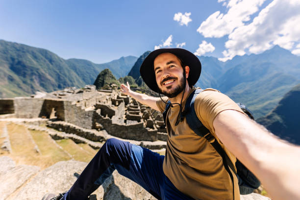
Happy young adult man taking selfie portrait in Machu Picchu. Joyful traveler enjoying vacation visiting Peru. South american travel holidays concept.

Taquile is an island on the Peruvian side of Lake Titicaca 45 km offshore from the city of Puno. About 1,700 people live on the island, which is 5.5 by 1.6 km in size (maximum measurements), with an area of 5.72 km2. The highest point of the island is 4050 meters above sea level and the main village is at 3950 m. The inhabitants, known as Taquilenos, are southern Quechua speakers. Taquilenos run their society based on community collectivism and on the Inca moral code ama sua, ama llulla, ama qhilla, (Quechua for "do not steal, do not lie, do not be lazy"). The island is divided into six sectors or suyus for crop rotation purposes. The economy is based on fishing, terraced farming horticulture based on potato cultivation, and tourist-generated income from the approximately 40,000 tourists who visit each year.Taquilenos are known for their fine handwoven textiles and clothing, which are regarded as among the highest-quality handicrafts in Peru. Everyone on the island - children, women, and men - spins and weaves

Uros are a pre-Incan people that live on forty-two self-fashioned floating island in Lake Titicaca Puno, Peru and Bolivia. They form three main groups: Uru-Chipayas, Uru-Muratos and the Uru-Iruitos. The latter are still located on the Bolivian side of Lake Titicaca and Desaguadero River. The Uros use bundles of dried totora reeds to make reed boats (balsas mats), and to make the islands themselves. The Uros islands at 3810 meters above sea level are just five kilometers west from Puno port.http://bem.2be.pl/IS/peru_380.jpg

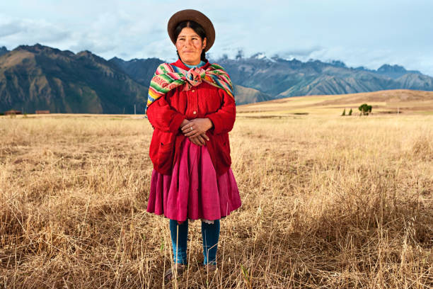
Peruvian women in national clothing admiring view of Andes in The Sacred Valley. The Sacred Valley of the Incas or Urubamba Valley is a valley in the Andes of Peru, close to the Inca capital of Cusco and below the ancient sacred city of Machu Picchu. The valley is generally understood to include everything between Pisac and Ollantaytambo, parallel to the Urubamba River, or Vilcanota River or Wilcamayu, as this Sacred river is called when passing through the valley. It is fed by numerous rivers which descend through adjoining valleys and gorges, and contains numerous archaeological remains and villages. The valley was appreciated by the Incas due to its special geographical and climatic qualities. It was one of the empire's main points for the extraction of natural wealth, and the best place for maize production in Peru.

The Sacred Valley of the Incas or Urubamba Valley is a valley in the Andes of Peru, close to the Inca capital of Cusco and below the ancient sacred city of Machu Picchu. The valley is generally understood to include everything between Pisac and Ollantaytambo, parallel to the Urubamba River, or Vilcanota River or Wilcamayu, as this Sacred river is called when passing through the valley. It is fed by numerous rivers which descend through adjoining valleys and gorges, and contains numerous archaeological remains and villages. The valley was appreciated by the Incas due to its special geographical and climatic qualities. It was one of the empire's main points for the extraction of natural wealth, and the best place for maize production in Peru.http://bem.2be.pl/IS/peru_380.jpg
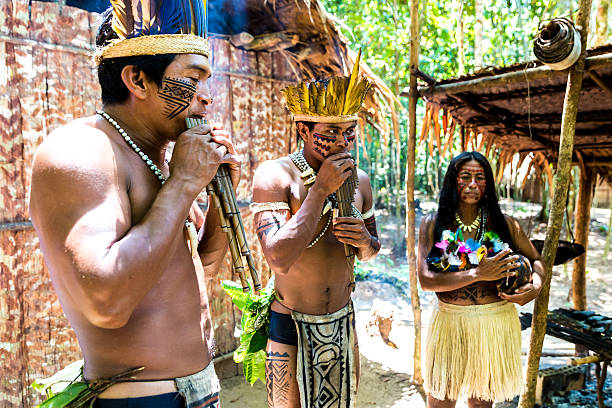
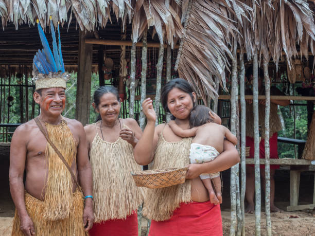
Native Brazilian group playing wooden flute at an indigenous tribe in the Amazon
The Sacred Valley of the Incas or Urubamba Valley is a valley in the Andes of Peru, close to the Inca capital of Cusco and below the ancient sacred city of Machu Picchu. The valley is generally understood to include everything between Pisac and Ollantaytambo, parallel to the Urubamba River, or Vilcanota River or Wilcamayu, as this Sacred river is called when passing through the valley. It is fed by numerous rivers which descend through adjoining valleys and gorges, and contains numerous archaeological remains and villages. The valley was appreciated by the Incas due to its special geographical and climatic qualities. It was one of the empire's main points for the extraction of natural wealth, and the best place for maize production in Peru.http://bem.2be.pl/IS/peru_380.jpg

Portrait of a happy female tourist walking around Cusco around the Cathedral and smiling - travel destinations concepts
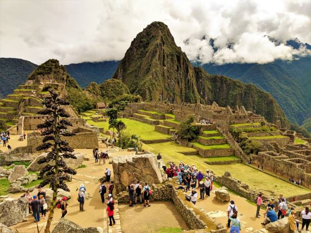
Ruins of Machu Picchu high angle view

The Sacred Valley of the Incas or Urubamba Valley is a valley in the Andes of Peru, close to the Inca capital of Cusco and below the ancient sacred city of Machu Picchu. The valley is generally understood to include everything between Pisac and Ollantaytambo, parallel to the Urubamba River, or Vilcanota River or Wilcamayu, as this Sacred river is called when passing through the valley. It is fed by numerous rivers which descend through adjoining valleys and gorges, and contains numerous archaeological remains and villages. The valley was appreciated by the Incas due to its special geographical and climatic qualities. It was one of the empire's main points for the extraction of natural wealth, and the best place for maize production in Peru.


Two teen latin friends with a skateboard using the mobile while sitting on stairs in the street


Next