A Wide Angle Shot of the City Lights of St. Paul, Minnesota Coming On during a Summer Twilight
Browse 50+ wabasha minnesota stock photos and images available, or search for great river road to find more great stock photos and pictures.
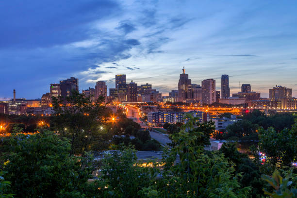
A Wide Angle Shot of the City Lights of St. Paul, Minnesota Coming On during a Summer Twilight

Aerial still image of Wabasha Street Bridge and Robert Street Bridge on Mississippi River at sunset. Authorization was obtained from the FAA for this operation in restricted airspace.

Aerial still image of downtown St. Paul, Minnesota, with Wabasha Street Bridge in frame, at twilight in Fall. Authorization was obtained from the FAA for this operation in restricted airspace.

The Wabasha street bridge over the Chicago river with the skyline just before sunrise.

Aerial still image of downtown St. Paul. Minnesota at twilight in Fall. Authorization was obtained from the FAA for this operation in restricted airspace.

A view looking north of the upper Mississippi River, shot from the Wabasha bridge. To the left is Minnesota, the right Wisconsin, a few power lines cross in the sky.

Photo of the Wabasha Street Bridge in Saint Paul taken from underneath the deck showing pedestrian walkway

concrete spans of wabasha street bridge in downtown saint paul minnesota

Saint Paul skyline form Wabasha Street Freedom Bridge, Saint Paul, Minnesota

Saint Paul skyline form Wabasha Street Freedom Bridge, Saint Paul, Minnesota

Maps of Wabasha County - Minnesota, on blue and red backgrounds. Four map versions included in the bundle: - One map on a blank blue background. - One map on a blue background with the word "Democrat". - One map on a blank red background. - One map on a red background with the word "Republican". Vector Illustration (EPS file, well layered and grouped). Easy to edit, manipulate, resize or colorize. Vector and Jpeg file of different sizes.

Aerial still image of downtown St. Paul, Minnesota, with Mississippi River and Wabasha Street Bridge in frame on a fall sunset. Authorization was obtained from the FAA for this operation in restricted airspace.

Map of Wabasha County - Minnesota, isolated on a blank background and with his name on a red ribbon. Vector Illustration (EPS file, well layered and grouped). Easy to edit, manipulate, resize or colorize. Vector and Jpeg file of different sizes.

Eagle's head in front of an American Flag.

Saint Paul skyline form Wabasha Street Freedom Bridge, Saint Paul, Minnesota

Black highlighted location map of the Wabasha County inside gray map of the Federal State of Minnesota, USA

The Wabasha Street Bridge in Saint Paul with american flags, Minnesota.

The Wabasha Street Bridge in Saint Paul with american flags, Minnesota.

The Wabasha Street Bridge in Saint Paul with american flags, Minnesota.

Aerial still image of downtown St. Paul, Minnesota, with Wabasha Street Bridge in frame, at twilight in Fall. Authorization was obtained from the FAA for this operation in restricted airspace.

Map of Wabasha County - Minnesota, for your own design. Four maps with editable stroke included in the bundle: - One black map on a white background. - One blank map on a black background. - One white map with shadow on a blank background (for easy change background or texture). - One line map with only a thin black outline (in a line art style). The layers are named to facilitate your customization. Vector Illustration (EPS file, well layered and grouped). Easy to edit, manipulate, resize or colorize. Vector and Jpeg file of different sizes.

Map of Wabasha County - Minnesota, with a large group of people. The faces are blue and red and represent patriots. The color blue for the Democratic Party and the color red for the Republican Party. Conceptual creative map, can symbolize the unity, cooperation, teamwork, patriotism... Vector Illustration (EPS file, well layered and grouped). Easy to edit, manipulate, resize or colorize. Vector and Jpeg file of different sizes.

Aerial still image of Wabasha Street Bridge in St. Paul, Minnesota on a Fall sunset. Authorization was obtained from the FAA for this operation in restricted airspace.

Map of Wabasha County - Minnesota, on a blue and red colored background. The blue color represents the Democratic Party and the red color represents the Republican Party. White stars are placed above and below the map. Vector Illustration (EPS file, well layered and grouped). Easy to edit, manipulate, resize or colorize. Vector and Jpeg file of different sizes.

3D Map of Wabasha County - Minnesota, isolated on a blank and gray background, with a dropshadow. Vector Illustration (EPS file, well layered and grouped). Easy to edit, manipulate, resize or colorize. Vector and Jpeg file of different sizes.

Autumn decorations along the sidewalk in a small town

Autumn decorations along the sidewalk in a small town

Map of Wabasha County - Minnesota, with a realistic paper cut effect isolated on white background. Trendy paper cutout effect. Vector Illustration (EPS file, well layered and grouped). Easy to edit, manipulate, resize or colorize. Vector and Jpeg file of different sizes.

Map of Wabasha County - Minnesota, in a trendy vintage style. Beautiful retro illustration with old textured paper and light rays in the background (colors used: blue, green, beige and black for the outline). Vector Illustration (EPS file, well layered and grouped). Easy to edit, manipulate, resize or colorize. Vector and Jpeg file of different sizes.

Wabasha Street bridge at dusk illuminated by street lamps in Saint Paul Minnesota

The bridge over the Mississippi river leading to Wabasha, Minnesota.

Aerial still image of downtown St. Paul, Minnesota, with Mississippi River and Wabasha Street Bridge in frame on a fall sunset. Authorization was obtained from the FAA for this operation in restricted airspace.

Illustration of Frozen Mississippi River at Wabasha, Minnesota


