
Vectors
Tijuana Flag stock vectors
Browse 140+ tijuana flag stock illustrations and vector graphics available royalty-free, or start a new search to explore more great stock images and vector art.
Most popular

National mexican flag ribbon. Curly ribbon on white background. Vector illustration.
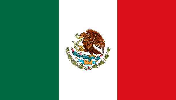
The flag of the United Mexican States (Mexico). Drawn in the correct aspect ratio. File is built in the CMYK color space for optimal printing, and can easily be converted to RGB without any color shifts.


The Coat of Arms of the United Mexican States (Mexico). File is built in the CMYK color space for optimal printing, and can easily be converted to RGB without any color shifts.

Currency of Mexico. Flat vector illustration of mexican two hundred peso.


Vector maps of Mexico with variable specification and icons
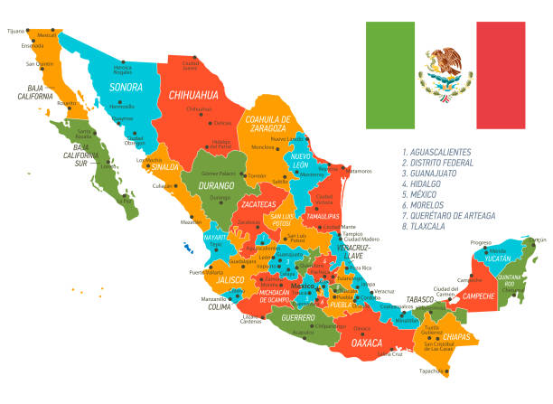
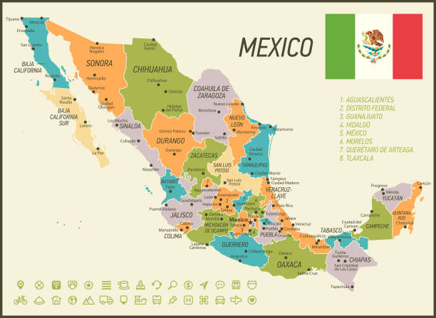
Highly detailed map of Mexico with administrative divisions, cities and flag

Vector maps of the Mexico with variable specification and icons The urls of the reference files are (country, continent, world map and globe): http://www.lib.utexas.edu/maps/americas/mexico_pol97.jpg http://www.lib.utexas.edu/maps/world_maps/time_zones_ref_2011.pdf http://www.lib.utexas.edu/maps/americas/north_america_ref_2010.pdf. In addition - some region boundaries and city locations were taken from: http://www.lib.utexas.edu/maps/united_states/usa_pol01.jpg http://www.lib.utexas.edu/maps/americas/mexico_pol97.jpg http://www.lib.utexas.edu/maps/americas/canada_pol_1986.gif - The illustration was completed May 22, 2016 and created in Corel Draw - 1 layer of data used for the detailed outline of the land

Mexico contour vector map with flag in color. Background map eps 10
Mexico vector map with borders,cities and national Mexican flag


Mexico contour vector map with state, black-white, flag in color. Background map eps 10
Mexico vector map with borders,cities and national Mexican flag

Silhouette and colored Mexico map
Mexico vector map with borders,cities and national Mexican flag
Mexico vector map with borders,cities and national Mexican flag

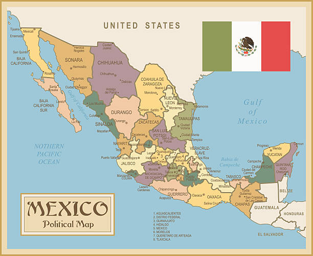
A detailed map of Mexico with indexes of major cities of the country. National flag of the state. Vector illustration.
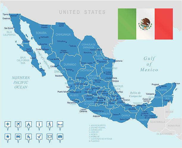
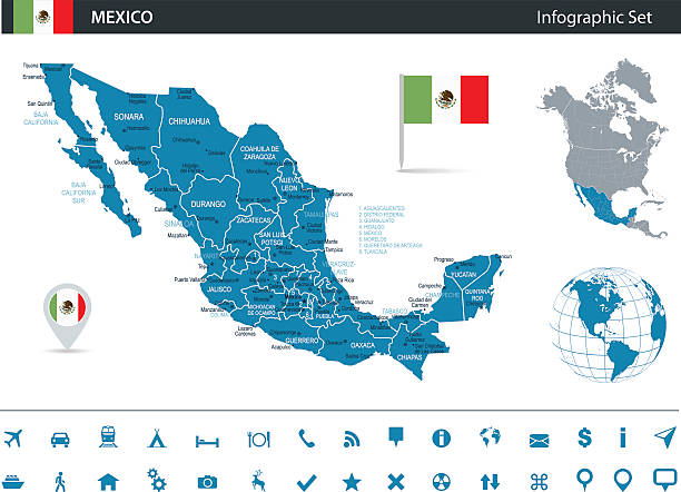
Blue Map of Mexico and Navigation Icons The urls of the reference files are (country, continent, world map and globe): http://www.lib.utexas.edu/maps/americas/mexico_pol97.jpg http://www.lib.utexas.edu/maps/world_maps/time_zones_ref_2011.pdf http://www.lib.utexas.edu/maps/americas/north_america_ref_2010.pdf. In addition - some region boundaries and city locations were taken from: http://www.lib.utexas.edu/maps/united_states/usa_pol01.jpg http://www.lib.utexas.edu/maps/americas/mexico_pol97.jpg http://www.lib.utexas.edu/maps/americas/canada_pol_1986.gif - The illustration was completed May 20, 2016 and created in Corel Draw - 1 layer of data used for the detailed outline of the land

Vector map of Mexico with variable specification and icons The urls of the reference files are (country, continent, world map and globe): http://www.lib.utexas.edu/maps/americas/mexico_pol97.jpg http://www.lib.utexas.edu/maps/world_maps/time_zones_ref_2011.pdf http://www.lib.utexas.edu/maps/americas/north_america_ref_2010.pdf. In addition - some region boundaries and city locations were taken from: http://www.lib.utexas.edu/maps/united_states/usa_pol01.jpg http://www.lib.utexas.edu/maps/americas/mexico_pol97.jpg http://www.lib.utexas.edu/maps/americas/canada_pol_1986.gif - The illustration was completed January 13, 2016 and created in Corel Draw - 1 layer of data used for the detailed outline of the land

Map of Mexico - Vector illustration
Mexico vector map with borders,cities and national Mexican flag


Map of Mexico - Vintage Vector illustration

Blue and Green Map of Mexico The urls of the reference files are (country, continent, world map and globe): http://www.lib.utexas.edu/maps/americas/mexico_pol97.jpg http://www.lib.utexas.edu/maps/world_maps/time_zones_ref_2011.pdf http://www.lib.utexas.edu/maps/americas/north_america_ref_2010.pdf. In addition - some region boundaries and city locations were taken from: http://www.lib.utexas.edu/maps/united_states/usa_pol01.jpg http://www.lib.utexas.edu/maps/americas/mexico_pol97.jpg http://www.lib.utexas.edu/maps/americas/canada_pol_1986.gif - The illustration was completed May 06, 2016 and created in Corel Draw - 1 layer of data used for the detailed outline of the land


Mexico vector map with borders,cities and national Mexican flag
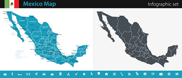
Mexico detailed Map with editable Regions and Navigation Icons

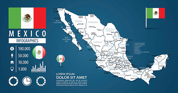
Vector map of Mexico with infographic elements


Map of Mexico - Vintage Vector illustration

Map of Mexico - Vintage Vector illustration


Mexico Map https://maps.lib.utexas.edu/maps/americas/mexico.gif

Vector crystal gem jewelry Mexican heart with the flag of the United Mexican States. Flat style logo symbol of love Mexico. Constitution Day. Flag Day

Map of Mexico - illustration The urls of the reference files are (country, continent, world map and globe): http://www.lib.utexas.edu/maps/americas/mexico_pol97.jpg http://www.lib.utexas.edu/maps/world_maps/time_zones_ref_2011.pdf http://www.lib.utexas.edu/maps/americas/north_america_ref_2010.pdf. In addition - some region boundaries and city locations were taken from: http://www.lib.utexas.edu/maps/united_states/usa_pol01.jpg http://www.lib.utexas.edu/maps/americas/mexico_pol97.jpg http://www.lib.utexas.edu/maps/americas/canada_pol_1986.gif - The illustration was completed May 15, 2016 and created in Corel Draw - 1 layer of data used for the detailed outline of the land

Blue Map of Mexico The urls of the reference files are (country, continent, world map and globe): http://www.lib.utexas.edu/maps/americas/mexico_pol97.jpg http://www.lib.utexas.edu/maps/world_maps/time_zones_ref_2011.pdf http://www.lib.utexas.edu/maps/americas/north_america_ref_2010.pdf. In addition - some region boundaries and city locations were taken from: http://www.lib.utexas.edu/maps/united_states/usa_pol01.jpg http://www.lib.utexas.edu/maps/americas/mexico_pol97.jpg http://www.lib.utexas.edu/maps/americas/canada_pol_1986.gif - The illustration was completed May 16, 2016 and created in Corel Draw - 1 layer of data used for the detailed outline of the land
Blue Mexico Map The urls of the reference files are (country, continent, world map and globe): http://www.lib.utexas.edu/maps/americas/mexico_pol97.jpg http://www.lib.utexas.edu/maps/world_maps/time_zones_ref_2011.pdf http://www.lib.utexas.edu/maps/americas/north_america_ref_2010.pdf. In addition - some region boundaries and city locations were taken from: http://www.lib.utexas.edu/maps/united_states/usa_pol01.jpg http://www.lib.utexas.edu/maps/americas/mexico_pol97.jpg http://www.lib.utexas.edu/maps/americas/canada_pol_1986.gif - The illustration was completed May 03, 2016 and created in Corel Draw - 1 layer of data used for the detailed outline of the land
Isolated Blue Map of Mexico The urls of the reference files are (country, continent, world map and globe): http://www.lib.utexas.edu/maps/americas/mexico_pol97.jpg http://www.lib.utexas.edu/maps/world_maps/time_zones_ref_2011.pdf http://www.lib.utexas.edu/maps/americas/north_america_ref_2010.pdf. In addition - some region boundaries and city locations were taken from: http://www.lib.utexas.edu/maps/united_states/usa_pol01.jpg http://www.lib.utexas.edu/maps/americas/mexico_pol97.jpg http://www.lib.utexas.edu/maps/americas/canada_pol_1986.gif - The illustration was completed May 18, 2016 and created in Corel Draw - 1 layer of data used for the detailed outline of the land

Infographic Map of Mexico - illustration The urls of the reference files are (country, continent, world map and globe): http://www.lib.utexas.edu/maps/americas/mexico_pol97.jpg http://www.lib.utexas.edu/maps/world_maps/time_zones_ref_2011.pdf http://www.lib.utexas.edu/maps/americas/north_america_ref_2010.pdf. In addition - some region boundaries and city locations were taken from: http://www.lib.utexas.edu/maps/united_states/usa_pol01.jpg http://www.lib.utexas.edu/maps/americas/mexico_pol97.jpg http://www.lib.utexas.edu/maps/americas/canada_pol_1986.gif - The illustration was completed May 04, 2016 and created in Corel Draw - 1 layer of data used for the detailed outline of the land

Blue Map of Mexico The urls of the reference files are (country, continent, world map and globe): http://www.lib.utexas.edu/maps/americas/mexico_pol97.jpg http://www.lib.utexas.edu/maps/world_maps/time_zones_ref_2011.pdf http://www.lib.utexas.edu/maps/americas/north_america_ref_2010.pdf. In addition - some region boundaries and city locations were taken from: http://www.lib.utexas.edu/maps/united_states/usa_pol01.jpg http://www.lib.utexas.edu/maps/americas/mexico_pol97.jpg http://www.lib.utexas.edu/maps/americas/canada_pol_1986.gif - The illustration was completed May 19, 2016 and created in Corel Draw - 1 layer of data used for the detailed outline of the land

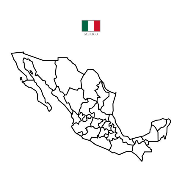
mexico map with regions isolated on white background. Map of mexico. Vector illustration


mexico map with mexican elements vector illustration graphic design

mexico map with mexican elements vector illustration graphic design

Highly detailed map of Mexico with administrative divisions, cities and flag

State of Baja California with municipalities and location on Mexican map. Vector image

Vector map of Mexico with variable specification and icons

Vector map of Mexico with variable specification and icons

http://s017.radikal.ru/i404/1110/87/2c00b7bbd3ec.jpg
Mexico contour vector map with state, flag in color. Background map eps 10
Vector maps of Mexico with variable specification and icons
Next