00:47
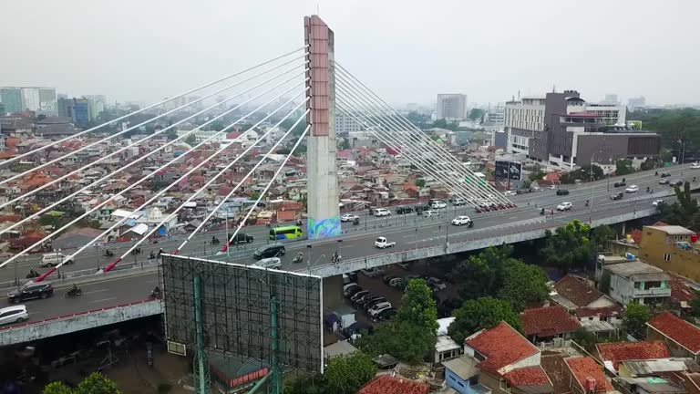
Pasupati Bridge is a bridge that connects the north and east of Bandung through the Cikapundung valley. It has a length of 2.8 km and a width of 30–60 m
Pasupati Bridge is a bridge that connects the north and east of Bandung through the Cikapundung valley. It has a length of 2.8 km and a width of 30–60 m

Aerial view of the High speed orange train on the railway station. High Speed Train Jakarta-Bandung

Aerial view of the High speed orange train on the railway station. High Speed Train Jakarta-Bandung

FullHD Timelapse - Bandung, West Java, Indonesia, June 2016.

BANDUNG, Indonesia - July 18, 2019: Aerial scenery of Satay Building also known as governor office building in Bandung city, West Java, Indonesia. Shot in 4k resolution from a drone flying forwards

Bandung, West Java, Indonesia - 15 September 2023 : The Simpang Lima Monument stands as a symbol of the Asia-Africa Conference, also known as the Bandung Conference, which took place in April 1955. This monument consists of 11 vertically stacked cubes, reaching a height of 15 meters. Each face of these cubes bears the names of the 109 nations that took part in this significant historical event. Positioned at opposite sides of the uppermost cube are analog clocks, and at the pinnacle flies the national flag of Indonesia

Beautiful aerial landscape of Bandung city with residential houses on misty morning, West Java, Indonesia. Shot in 4k resolution

Aerial Shot of an overpopulated residential district of Bandung city. View of the dense residential landscape in Downton. Drone Footage.Top View. Cinematic. Shot from a drone 4K Resolution 30 Fps

BANDUNG, Indonesia - June 17, 2019: Beautiful aerial view of Al Jabbar Great Mosque on misty morning. Shot in 4k resolution from a drone flying from left to right

Beautiful aerial landscape of Bandung city with residential houses on misty morning, West Java, Indonesia. Shot in 4k resolution

FullHD Timelapse - Bandung, West Java, Indonesia, June 2016.

Pasupati Bridge is a bridge that connects the north and east of Bandung through the Cikapundung valley. It has a length of 2.8 km and a width of 30–60 m

FullHD Timelapse - Bandung, West Java, Indonesia, June 2016.

Beautiful aerial view of Bandung cityscape on misty morning, West Java, Indonesia. Shot in 4k resolution

Beautiful aerial view of golf course with Bandung city background on misty morning at West Java, Indonesia. Shot in 4k resolution

Aerial view of the High speed orange train on the railway station. High Speed Train Jakarta-Bandung

Jalan Asia Afrika in Bandung City, West Java, Indonesia. Jl. Asia Afrika is one of the most important streets in downtown Bandung being the financial center of Bandung and also having many old Dutch colonial buildings on both sides of the street.

Gedung Sate, a remarkable architectural gem situated in Bandung, West Java, Indonesia, is a blend of history, art, and culture. This iconic building, whose name translates to "Satay Building" in English, stands as a symbol of the city's rich heritage and Dutch colonial influence

Fast moving transport on the crossroad Otista street in Bandung city. Traffic of vehicles and people on highway and intersection streets in Metropolis. Time lapse.

Transportation Footage. Aerial Landscapes. Timelapse video of Cileunyi - Garut Highway road. Aerial Shot from a flying drone in 4K Resolution

Transportation Footage. Aerial Landscapes. Timelapse video of Cicalengka Station road. Aerial Shot from a flying drone in 4K Resolution

Aerial Footage. A landscape view of dense residential areas on the edge of the city of Bandung - Indonesia. Densely populated settlement. Shot in 4k resolution from a drone flying

Aerial Footage. A landscape view of dense residential areas on the edge of the city of Bandung - Indonesia. Densely populated settlement. Shot in 4k resolution from a drone flying

Bandung, West Java, Indonesia - 2023/01/15: Masjid Raya Al-Jabbar is dubbed as the 'Floating Mosque' because it was founded in the middle of a lake located on an area of 26 hectares in the Gedebage area, Bandung City, West Java

Bandung, West Java, Indonesia - 2023/01/15: Masjid Raya Al-Jabbar is dubbed as the 'Floating Mosque' because it was founded in the middle of a lake located on an area of 26 hectares in the Gedebage area, Bandung City, West Java

Aerial view of the Al Jabar Floating Mosque in Bandung, when the construction was almost finished

Transportation Footage. Aerial Landscapes. Timelapse video of Cileunyi - Garut Highway road. Aerial Shot from a flying drone in 4K Resolution

City Hall (Alun-Alun) and The Great Mosque of Bandung City, popular landmark in Bandung City, West Java, Indonesia

Bandung, Indonesia - June 17, 2019: Beautiful aerial landscape of Al Jabbar Great Mosque on the morning. Shot in 4k resolution from a drone flying from left to right

Bandung, Indonesia - June 17, 2019: Beautiful aerial scenery of Al Jabbar Mosque on the morning. Shot in 4k resolution from a drone flying forwards

Bandung, Indonesia - June 17, 2019: Beautiful aerial view of Al Jabbar floating Great Mosque under construction. Shot in 4k resolution from a drone flying from left to right

Transportation Footage. Aerial Landscapes. Timelapse video of Cicalengka Station road. Aerial Shot from a flying drone in 4K Resolution

Transportation Footage. Aerial Landscapes. Timelapse video of Cileunyi - Garut Highway road. Aerial Shot from a flying drone in 4K Resolution

Transportation Footage. Aerial Landscapes. Timelapse video of Cicalengka Station road. Aerial Shot from a flying drone in 4K Resolution

Aerial Drone Footage View of valley and plateau in Bandung Region, Indonesia. The plateau known as Caringin Tilu, panoramic cityscape landscape from the top of the hill. Scenic Nature in 4K Resolution

Aerial Drone Footage View of valley and plateau in Bandung Region, Indonesia. The plateau known as Caringin Tilu, panoramic cityscape landscape from the top of the hill. Scenic Nature in 4K Resolution

View from above, stunning aerial view of the Tangkuban Perahu volcano with clouds of gases raising from the crater. Tangkuban Perahu is an active volcano, situated 30 km north of the city of Bandung, Indonesia

Aerial Drone Footage View of valley and plateau in Bandung Region, Indonesia. The plateau known as Caringin Tilu, panoramic cityscape landscape from the top of the hill. Scenic Nature in 4K Resolution

Aerial Drone Footage View of valley and plateau in Bandung Region, Indonesia. The plateau known as Caringin Tilu, panoramic cityscape landscape from the top of the hill. Scenic Nature in 4K Resolution

Aerial Drone Footage View of valley and plateau in Bandung Region, Indonesia. The plateau known as Caringin Tilu, panoramic cityscape landscape from the top of the hill. Scenic Nature in 4K Resolution

Aerial Footage. A landscape view of dense residential areas on the edge of the city of Bandung - Indonesia. Densely populated settlement. Shot in 4k resolution from a drone flying

Drone Videography. Aerial Footage. Landscape view of public housing on the edge of Bandung city, filled with densely populated residential areas. Shot in 4k resolution from a flying drone. Asia

Drone Videography. Aerial Footage. Landscape view of public housing on the edge of Bandung city, filled with densely populated residential areas. Shot in 4k resolution from a flying drone. Asia

Aerial Footage. A landscape view of dense residential areas on the edge of the city of Bandung - Indonesia. Densely populated settlement. Shot in 4k resolution from a drone flying

Bandung, West Java, Indonesia - 2023/01/15: Masjid Raya Al-Jabbar is dubbed as the 'Floating Mosque' because it was founded in the middle of a lake located on an area of 26 hectares in the Gedebage area, Bandung City, West Java

Aerial Footage. Bird's eye shot of traffic in and out of vehicles at the Purbaleunyi toll gate during homecoming, Bandung - Indonesia

Drone Footage. Aerial video view of the stone and sand mining area on the slopes of Mount Pangradinan, Cikancung - Bandung, Indonesia. Stone and sand mining. 4K Resolution

Aerial Shot of Bandung Sea of Fire Monument in Tegalega park, Bandung - Indonesia. Top view National monument. Aerial Videography. Drone Footage. Shot in 4K Resolution 30 Fps

Aerial Footage. Timelapse video Landscape view of dense residential areas on the edge of the city of Bandung - Indonesia. Densely populated settlement. Shot in 4k resolution from a drone flying

Drone Footage. Aerial video view of the stone and sand mining area on the slopes of Mount Pangradinan, Cikancung - Bandung, Indonesia. Stone and sand mining. 4K Resolution

Aerial Shot of Bandung Sea of Fire Monument in Tegalega park, Bandung - Indonesia. Top view National monument. Aerial Videography. Drone Footage. Shot in 4K Resolution 30 Fps
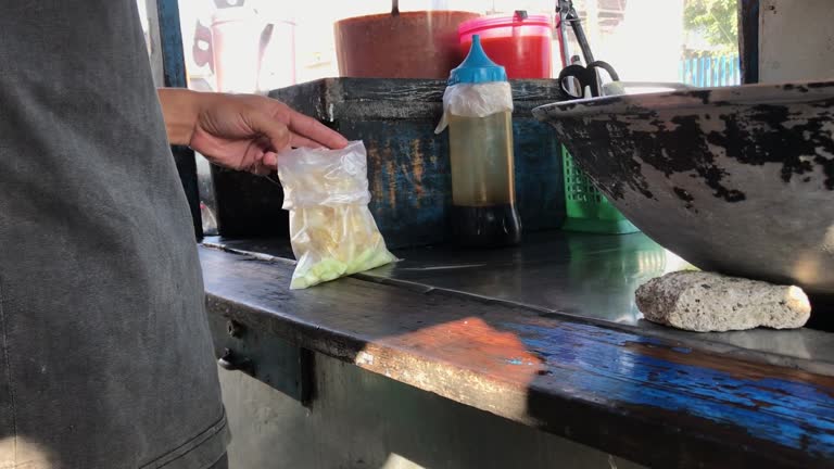
An Indonesian street food vendor serves a customer. A man preparing a dish called 'batagor' to customer on the street

Seamless looping animation of the 3d terrain map of Indonesia with the capital and the biggest cites in 4K resolution

High quality video of zoom to the City of Bandung from space * Full HD * Duration: 0:20

Beautiful aerial view of Bandung cityscape on misty morning, West Java, Indonesia. Shot in 4k resolution

Aerial Videos. Aerial Drone Footage landscape view of a village road that divides a wide rice field. Road access on the outskirts of Koota Bandung - Indonesia, Asia. High Quality 4k Videos

Aerial Videos. Aerial Drone Footage landscape view of a village road that divides a wide rice field. Road access on the outskirts of Koota Bandung - Indonesia, Asia. High Quality 4k Videos

Aerial Videos. Aerial Drone Footage landscape view of a village road that divides a wide rice field. Road access on the outskirts of Koota Bandung - Indonesia, Asia. High Quality 4k Videos

Tilt Up up Camera movement country lane area near plantations, countryside, and mountains

Beautiful aerial view of golf course with Bandung city background on misty morning at West Java, Indonesia. Shot in 4k resolution

Beautiful aerial view of residential houses on misty morning in Bandung city, West Java, Indonesia. Shot in 4k resolution

Beautiful aerial view of residential houses on misty morning in Bandung city, West Java, Indonesia. Shot in 4k resolution
© 2025 iStockphoto LP. The iStock design is a trademark of iStockphoto LP. Browse millions of high-quality stock photos, illustrations, and videos.
Do Not Sell or Share


