Map from “A History of the United States for America for Schools” 1895
Browse 230+ civil war map united states stock illustrations and vector graphics available royalty-free, or start a new search to explore more great stock images and vector art.
Map from “A History of the United States for America for Schools” 1895

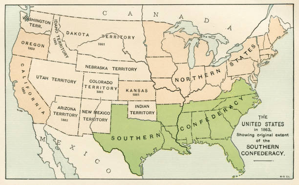
Map with the Union and Confederate states and the status of slavery during American Civil war
Map of the United States Civil War military campaigns. Illustration published in The New Eclectic History of the United States by M. E. Thalheimer (American Book Company; New York, Cincinnati, and Chicago) in 1881 and 1890. Copyright expired; artwork is in Public Domain.

Illustrated pictorial map of eastern United States. Includes Pennsylvania, New Jersey, West Virginia, Virginia, North Carolina, Delaware and Maryland. Vector Illustration.

Map of Port Hudson and it's Defences

shattered divided usa outline of america splintered from centre in red and blue republican democrat political divides with ray starburst and grunge texture background illustration

Burning map of United States of America Constitution with "We the People" caption. Presidential election political crisis, inauguration, civil war, breakup conflict, concept vector illustration.

American Civil War map of Atlanta. Georgia, USA. Illustration engraving published 1895. Original edition is from my own archives. Copyright has expired and is in Public Domain.

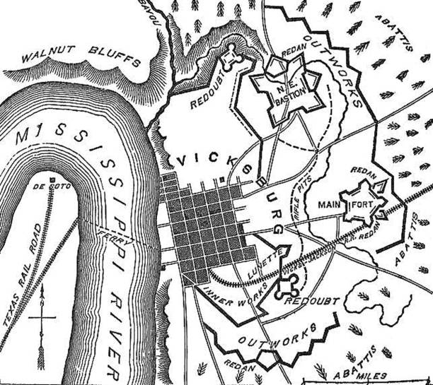
Vintage engraving of a plan of the Siege of Vicksburg the final major military action in the Vicksburg campaign of the American Civil War.

From Barness Primary History of the United States published in 1885
vector map of virginia and related icons.
Vector map and icons bout the state of maryland, USA.
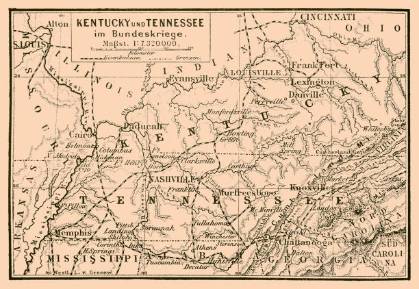
Illustration of a Kentucky and Tennessee in federal war map
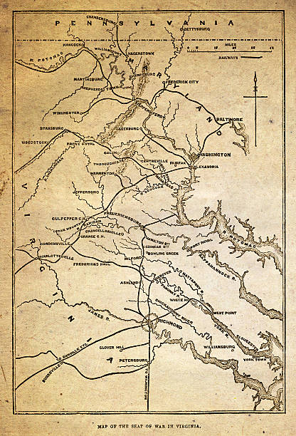
A map of the 'seat' of the American civil war in Virginia from ”The Leisure Hour”, a British “Journal of Instruction and Recreation”. This edition was published in May 1864. Virginia was one of the Confederate States during the Civil War of 1861-65.

Illustration of a Map of the battles around Vicksburg

Vintage engraving from 1863 of a map of the Battle of Belmont which was fought on November 7, 1861, in Mississippi County, Missouri. It was the first combat test in the American Civil War for Brig. Gen. Ulysses S. Grant. On November 6, Grant sailed from Cairo, Illinois, to attack the Confederate fortress at Columbus, Kentucky. The next morning, he learned that Confederate troops had crossed the Mississippi River to Belmont, Missouri. He landed his men on the Missouri side and marched to Belmont. Grant's troops overran the Confederate camp and destroyed it. However, the scattered Confederate forces quickly reorganized and were reinforced from Columbus. They then counterattacked, supported by heavy artillery fire from across the river. Grant retreated to his riverboats and took his men to Paducah, Kentucky.

Vintage engraving of the Battle of Shiloh also known as the Battle of Pittsburg Landing, was a major battle in the Western Theater of the American Civil War, fought April 6–7, 1862, in southwestern Tennessee.

Vintage engraving from 1863 of a map of Bull Run and its environs at the time of the American Civil War. The First Battle of Bull Run, also known as the First Battle of Manassas (the name used by Confederate forces), was fought on July 21, 1861, in Prince William County, Virginia, near the City of Manassas. It was the first major land battle of the American Civil War. And resulted in a Confederate victory.

Chattanooga and it's Defences19th Century Engraving

Relief map of the battlefield in Gettysburg - Scanned 1887 Engraving

"Vintage engraving from 1863 of a map of the Battle of Port Royal which was one of the earliest amphibious operations of the American Civil War, in which a United States Navy fleet and United States Army expeditionary force captured Port Royal Sound, South Carolina."

Map of Charleston Harbor, South Carolina, during the United States Civil War. The first battle in the harbor was 1963. Illustration published in The New Eclectic History of the United States by M. E. Thalheimer (American Book Company; New York, Cincinnati, and Chicago) in 1881 and 1890. Copyright expired; artwork is in Public Domain.

"Vintage engraving from 1863 of a map of the Battle of Big Bethel also known as the Battle of Bethel Church or Great Bethel was an American Civil War battle that took place on June 10, 1861, in Hampton and York County, Virginia. And resulted in a Confederate victory."

"Engraving Of A Map From 1862 Featuring Pensacola Bay, Florida, USA."

Engraving From 1863 Showing Savannah, Tybee Island, And Fort Pulaski During The Civil War.

Map of Kentucky and Tennessee - 1886 scanned engraving

"Vintage engraving from 1863 of a map of the Battle of Fort Donelson which was fought from February 11 to February 16, 1862, in the Western Theater of the American Civil War. The capture of the fort by Union forces opened the Cumberland River as an avenue for the invasion of the South."

Gettysburg Battle Map Positions July 1st 1861 - Scanned 1887 Engraving
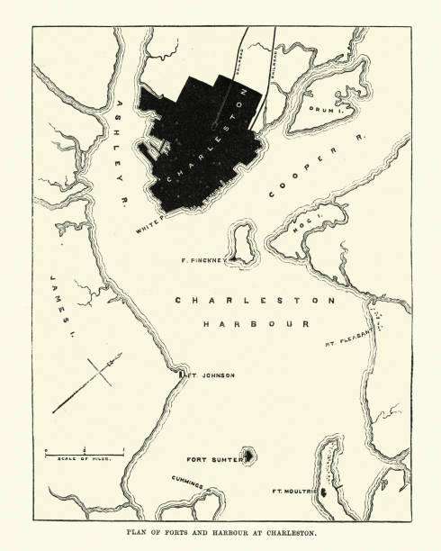
Vintage engraving of Plan of Forts and Harbour at Charlestown, South Carolina, 1860s, 19th Century

Illustration of a Plan of the battle at Gettysburg

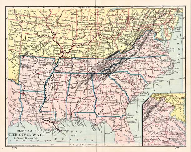
Map of Civil War Map of Operations in the West, United States History. Illustration published in First Lessons in Our Country’s History by William Swinton, A.M. (Ivison, Blakeman, Taylor, & Company, New York and Chicago) in 1872.

Vintage engraving of Map of Confederate army from Richmond and Petersburg during the American Civil War.
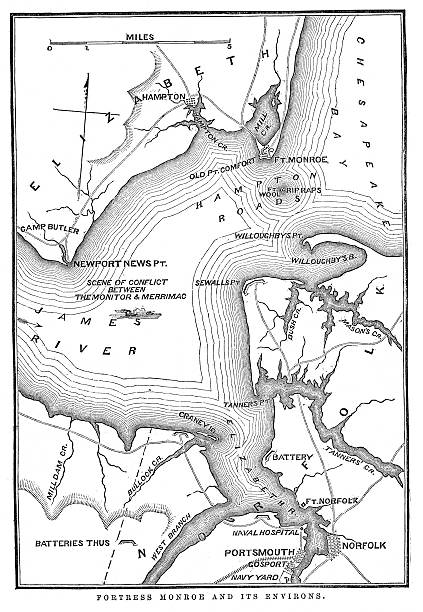
"Vintage engraving from 1863 of a map of Fort Monroe and its environs. Fort Monroe played an important role in the American Civil War. It was held by Union forces throughout the Civil War, which launched several sea and land expeditions from there."

A vector illustration of Sudan and South Sudan maps, each filled with their respective flag texture. Sudan in the north with red, white, black, and green; South Sudan in the south with black, red, green, white, blue, and yellow. A visual representation of each country’s national identity, highlighting their geographical and cultural division.

American Typography Design, fit for t-shirt, poster, sticker, background, or other media you need

Concept for a Patriotic Map of South Carolina

Vintage engraving of Plan of Richmond, Virginia during American Civil War

Engraving From 1863 Featuring The Southern American States Of Louisiana, Arkansas, And Missouri From The Time Of The American Civil War.

Gettysburg battlefield map, Pennsylvania. USA. Illustration engraving published 1895. Original edition is from my own archives. Copyright has expired and is in Public Domain.

Map of various battles fought at and around Atlanta in the western theater of the American Civil War in Georgia, USA (circa 1864). Vintage etching circa 19th century.

American Civil War map of Dalton, Georgia, USA. Illustration engraving published 1895. Original edition is from my own archives. Copyright has expired and is in Public Domain.

Vintage engraving of a Map of the Battle of Bull Run, The Century Magazine, 1884