Illustrations
485 Illustrations
View guyana drawing videos
Browse 480+ guyana drawing stock illustrations and vector graphics available royalty-free, or start a new search to explore more great stock images and vector art.

doodle freehand drawing of south america map. vector illustration.

vector of the South America map

Flags of South America set sketch. Hand drawn Doodle Vector illustration

Flags of the American continent. Set of all 35 countries of America. Colorful Sketch style.


vector map of south america in hand drawn style

web buttons with south america country flags in flat

Guyana - detailed map with administrative divisions country. Vector illustration

Guyana detailed map with regions and cities of the country. Vector illustration

Detailed map of Venezuela with country flag and location on world map. Vector illustration

Set of hand written calligraphic lettering quotes with Latin American countries names, decorative ornament. Isolated objects on white background. Vector illustration. Design concept for banner, card.

vector of the South America map

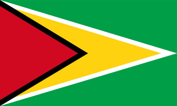
Detailed Illustration National Flag Guyana

Hand drawn vector map of South America with flags. Elements different layers. Perfect for infographics. Includes Brazil, Argentina, Chile, Paraguay, Uruguay, Colombia, Venezuela, Peru, Ecuador.

Hand drawn vector map of South America. Text, line and colors on different layers. Perfect for infographics. Includes Brazil, Argentina, Chile, Paraguay, Uruguay, Colombia, Venezuela, Peru, Ecuador.

vector of the South America map on transparent background
CARICOM flag graphic design element. Caribbean Community and Common Market flag icons in flat style. CARICOM symbols collection


Flags of the American continent. Set of all 35 countries of America. Colorful Sketch style.

Map of South America drawn with green highlighter, isolated on a squared paper sheet. Easily change color : yellow, orange, pink, purple, blue, green.

Hand drawn vector map of South America. Text, line and colors on different layers. Perfect for infographics. Includes Brazil, Argentina, Chile, Paraguay, Uruguay, Colombia, Venezuela, Peru, Ecuador.

vector of the South America map

vector of the South America map

Guyana - detailed blue country map with cities, regions, location on world map and globe. Infographic icons. Vector illustration

Map of Guyana isolated on a blank background with a black outline and shadow. Vector Illustration (EPS file, well layered and grouped). Easy to edit, manipulate, resize or colorize. Vector and Jpeg file of different sizes.

National flag of Guyana. Guyana flag vector illustration icon design in the hand-drawn style. Fluttering flagpole flag.

Guyana - detailed map with administrative divisions and country flag. Vector illustration

Guyanan flag brush stroke grunge background. Vector illustration.

vector of the South America map


Green guyabano fruit on white background. Soursop watercolor illustration. Tropical fruit soursup handdrawn clipart. Guyabano isolated. Exotic fruit soursop with green prickly skin. Summer travel food

South America map. hand drawn illustration.

vector of the South America map

vector of the South America map

Guyana hand drawn cartoon doodles illustration. Funny travel design. Chalkboard vector background. Latin America country elements and objects.

vector map of south america in hand drawn style

vector of the South America map


http://dikobraz.org/map_2.jpg

Cartoon doodles Guyana seamless pattern. Backdrop with local culture symbols and items. Colorful background for print on fabric, textile, greeting cards, scarves, wallpaper

Guyana hand drawn cartoon doodle illustration. Funny local design. Creative vector background. Handwritten text with Latin American elements and objects.

Scribble map of Guyana. Sketch Country map colors for infographic, brochures and presentations. Vector illustration eps 10


Top view of happy young man in swimwear lying on towel on beach enjoying summer vacations. Smiling guy relax on seaside during summertime holidays. Travel and tourism. Vector illustration.

vector of the South America map

vector of the South America map

Detailed illustration of a South America Map on Vintage Handwriting BlackBoard.Illustration in EPS10 with color space in RGB.

Detailed map of Guyana with surroundings, provinces, capital and flag.

Victoria amazonica (formerly Victoria Regia), named after the british queen Victoria. It is the largest waterlily in the world. Wood engraving, published in 1894.
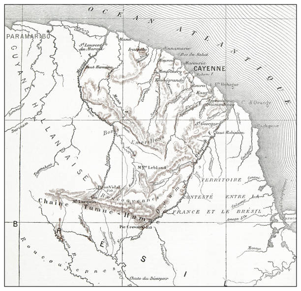

A steel engraving of a map from the early 19th century of Brazil and Paraguay in South America, from “A System of Geography, Popular and Scientific, or A Physical, Political, and Statistical Account of the World and its Various Divisions. Volume VI, Part II” by James Bell and published by A. Fullarton & Co., Glasgow, in 1838.

Venezuela administrative blue-green map with country flag and location on a globe. Vector illustration

Cartoon vector doodle set of Guyana traditional symbols, items and objects

A steel engraving of a map from the early 19th century of Brazil and Paraguay in South America, from “A System of Geography, Popular and Scientific, or A Physical, Political, and Statistical Account of the World and its Various Divisions. Volume VI, Part II” by James Bell and published by A. Fullarton & Co., Glasgow, in 1838.

3D map of Guyana isolated on a blank blueprint, with a dropshadow (color used: blue and white). Vector Illustration (EPS10, well layered and grouped). Easy to edit, manipulate, resize or colorize.

Map of Guyana isolated on a blank background with a black outline and shadow. Vector Illustration (EPS file, well layered and grouped). Easy to edit, manipulate, resize or colorize. Vector and Jpeg file of different sizes.

Flags of the American continent. Set of all 35 countries of America. Colorful Sketch style.

Detailed Venezuela administrative map with country flag and location on a blue globe. Vector illustration
of9Next