highly detailed map from California state & counties for your design and products.
Browse 40+ imperial county california stock illustrations and vector graphics available royalty-free, or start a new search to explore more great stock images and vector art.
highly detailed map from California state & counties for your design and products.

Large and detailed map of California - Imperial county

State of California counties, political map. U.S. state of California, subdivided into 58 counties, with San Bernardino County as largest and Los Angeles County as most populous in the United States.

Large and detailed map of Imperial County in California, USA.

Counties map of California state of United States of America. The map is accurately prepared by a map expert.

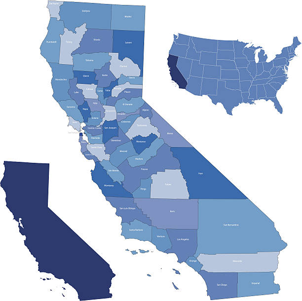
Counties map of California state of United Sates of America with county names in blue backgrounds

California county map outline vector illustration and its location highlighted on USA map

Highly detailed county map of California state of United States of America for web banner, mobile app, and educational use. The map is accurately prepared by a map expert.

Vector illustration of the El Centro (California) City Limit green road sign on metallic posts

Imperial County, California blank outline map set

The Saguaro (Carnegiea gigantea) - a tree-like cactus species in the monotypic genus Carnegiea that can grow to be over 12 meters (40 feet) tall. It is native to the Sonoran Desert in Arizona, the Mexican state of Sonora, and the Whipple Mountains and Imperial County areas of California. The saguaro blossom is the state wildflower of Arizona. Wood engraving, published in 1899.

Highly detailed map of California counties state of United States of America for book cover, brochure and web banner designs, iPhone, iPad, tablet, smart phone, mobile app and educational use.

Imperial County, California (Counties in California, United States of America,USA, U.S., US) map vector illustration, scribble sketch Imperial map

Highly detailed map of California state of United States of America for book cover, brochure and web banner designs, iPhone, iPad, tablet, smart phone, mobile app and educational use.

Imperial County, California (Counties in California, United States of America,USA, U.S., US) map vector illustration, scribble sketch Imperial map

3D Map of Imperial County - California, isolated on a blank and gray background, with a dropshadow. Vector Illustration (EPS file, well layered and grouped). Easy to edit, manipulate, resize or colorize. Vector and Jpeg file of different sizes.

Map of Imperial County - California for your own design. Three maps with editable stroke included in the bundle: - One black map on a white background. - One line map with only a thin black outline in a line art style (you can adjust the stroke weight as you want). - One map on a blank transparent background (for change background or texture). The layers are named to facilitate your customization. Vector Illustration (EPS file, well layered and grouped). Easy to edit, manipulate, resize or colorize. Vector and Jpeg file of different sizes.

Map of Imperial County - California, for your own design. Four maps with editable stroke included in the bundle: - One black map on a white background. - One blank map on a black background. - One white map with shadow on a blank background (for easy change background or texture). - One line map with only a thin black outline (in a line art style). The layers are named to facilitate your customization. Vector Illustration (EPS file, well layered and grouped). Easy to edit, manipulate, resize or colorize. Vector and Jpeg file of different sizes.

Map of Imperial County - California, in a trendy vintage style. Beautiful retro illustration with old textured paper and light rays in the background (colors used: blue, green, beige and black for the outline). Vector Illustration (EPS file, well layered and grouped). Easy to edit, manipulate, resize or colorize. Vector and Jpeg file of different sizes.

Map of Imperial County in California state on white background. single County map highlighted by black colour on California map. UNITED STATES, US

Map of Imperial County - California, isolated on a blank background and with his name on a red ribbon. Vector Illustration (EPS file, well layered and grouped). Easy to edit, manipulate, resize or colorize. Vector and Jpeg file of different sizes.

Map of Imperial County - California, with a realistic paper cut effect isolated on white background. Trendy paper cutout effect. Vector Illustration (EPS file, well layered and grouped). Easy to edit, manipulate, resize or colorize. Vector and Jpeg file of different sizes.

Map of Imperial County - California, on a blue and red colored background. The blue color represents the Democratic Party and the red color represents the Republican Party. White stars are placed above and below the map. Vector Illustration (EPS file, well layered and grouped). Easy to edit, manipulate, resize or colorize. Vector and Jpeg file of different sizes.

Map of Imperial County - California, on two blue and red rubber stamps. Two versions included in the bundle: - One blue stamp with the map in the middle and the word "Democrat" around. - One red stamp with the map in the middle and the word "Republican" around. And also two blue and red banners with the name of the county. Vector Illustration (EPS file, well layered and grouped). Easy to edit, manipulate, resize or colorize. Vector and Jpeg file of different sizes.

California want's to leave (exit) the United States of America. CALEXIT. 3D rendering.

California want's to leave (exit) the United States of America. CALEXIT. 3D rendering.

Highly detailed labeled map of California counties state of United States of America for book cover, brochure and web banner designs, iPhone, iPad, tablet, smart phone, mobile app and educational use.

Map of Imperial County - California, with a large group of people. The faces are blue and red and represent patriots. The color blue for the Democratic Party and the color red for the Republican Party. Conceptual creative map, can symbolize the unity, cooperation, teamwork, patriotism... Vector Illustration (EPS file, well layered and grouped). Easy to edit, manipulate, resize or colorize. Vector and Jpeg file of different sizes.

Maps of Imperial County - California, on blue and red backgrounds. Four map versions included in the bundle: - One map on a blank blue background. - One map on a blue background with the word "Democrat". - One map on a blank red background. - One map on a red background with the word "Republican". Vector Illustration (EPS file, well layered and grouped). Easy to edit, manipulate, resize or colorize. Vector and Jpeg file of different sizes.

Round button with detailed map of Imperial County in California, USA.

California want's to leave (exit) the United States of America. CALEXIT. 3D rendering.


