seaport from above
Browse 560+ industrial port top view stock illustrations and vector graphics available royalty-free, or start a new search to explore more great stock images and vector art.

Illustration of an island in the middle of the ocean. Cargo port in flat style. Top view.

Dockyard harbor terminal aerial top view with cargo ship and ocean boats vector illustration. Sea terminal port with cargo ship

Top view of logistics with cargo train and cargo ship at the shipping port.Warehouse loading hub.Semi trucks for loading or unloading goods,factory, industry and transportation,vector illustration.

Container ship, yachts, boats, sea transport in the port. Highway top view.

Wooden piers with boats. Container ship, yachts, boats, sea transport in the port. The helicopter flies over the ocean.

Ship and sea boats in dock. Top view illustrations ship and boat, water transportation vector

Yachts, boats, sea transport in the port. The helicopter flies over the ocean. Summer, sea, sand, umbrellas, palms.

Transport and logistics service concept. Sea freight service. International transport industry. Vector illustration.

Container ship. Aerial top view. Cargo to harbor. Vector illustration flat design

The five main types of cargo transportation in Brazil. Air, rail, waterway, pipeline and road. logistics of the map of brazil

Container ship, yachts, boats, sea transport in the port. Highway top view.

Top view sea ship vector illustration. Aerial view of ocean transport. Marine vessel with containers. Carriage and maritime transportation. Worldwide cargo shipments. Sea freight. Logistics banner.

seaport from above at night

Detailed line art of port Hamburg with the Elbphilharmonie. The illustration captures the waterfront, bridges, and industrial buildings along the Elbe River in a black and white sketch style.

Marine Shipping. Cargo port, Seagulls flying, containers. Top view. Ship, sea, shipping transport industry, crane. Editable vector illustration
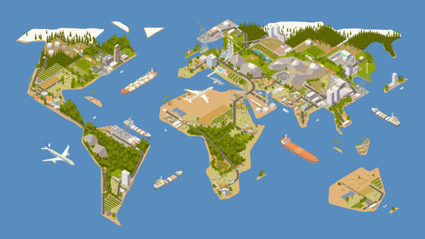
A stylized map of the world illustrated in rich detail includes oceans, forests, and mountains — along with modern supply chains depicted by roadways, railways, and shipping routes. These are utilized by cars, trucks, trains, and container ships, while airplanes, shipping ports, an oil pipeline and an oil tanker ship can also be seen. To supply these trade routes: farms, cattle fields, factories, oil fields, renewable energy sources, and a mining quarry are shown. Villages, towns, and cities dot the map as destinations for this commercial activity. An original stylized map created by the illustrator is presented in isometric view, while the art board uses a 16 x 9 ratio. Major landforms are presented in full color on a blue background.

Isometric port city with docked ship being loaded with containers

Top view of cargo port with cargo ship full of standard shipping containers .Semi trucks for loading or unloading goods.factory and industry, vector illustration.

Sea port, loading of cargo on Board. Marine shipping. Delivery of the goods. Color containers on the dock with a lifting crane. Seagulls flying on water. Editable vector illustration top view

Vintage engraving of View of Boston from Bunker's Hill, 19th Century
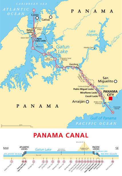
Panama Canal, political map and schematic diagram, illustrating the sequence of locks and passages. An artificial waterway, connecting the Atlantic Ocean with the Pacific Ocean, and expanded in 2016.

Architectural plan of rebuilding and development of a port harbour. Drawing of new city port.

Cargo Ship Illustration on green background

Aerial isometric illustration of a cargo port complete with container ships, cranes, a tug boat, shipping ports, and stacks of cargo containers.

Set of container loaders, gantry and level luffing cranes. Vector illustration isolated on white background

Fisherman and boy fishing in water of lake. Elderly grandfather and grandson sitting on old wooden pier to catch fish together, fun summer family adventure in nature cartoon vector illustration

Red Colored Industrial Ship Illustration. Isometric Container Ship. Vector Transport Icon.

This vector illustration shows a traditional Vietnamese junk boat with vibrant red sails gliding over calm waters, showcasing maritime beauty

Sum symbol made from Container ships. Zero sum. Economic concept. Vector Illustration

A vector illustration of a cargo ship cruising sea. Editable with objects logically layered.

Ferry terminal includes three docks, three boats, a tower and a terminal building. Scene is viewed from an aerial isometric perspective. Illustration will include high quality jpeg and vector eps files.

Cargo cranes in the seaport on white background

World map flight paths logistics background concept with plane, truck and train

Silhouettes of cargo cranes in the seaport

Historical view of Santa Marta - a city on the coast of the Caribbean Sea in northern Colombia. Founded on July 29, 1525, by the Spanish conqueror Rodrigo de Bastidas, it was one of the first Spanish settlements in Colombia. Wood engraving, published in 1899.

Wooden piers with boats. Container ship, yachts, boats, sea transport in the port. The helicopter flies over the ocean.

Aerial view LNG ship with storage tank for loading LNG onto sea vessel.Gas LNG pipeline.Import of methane and propane.gas pipes.Oil and gas fuel manufacturing industry.

Architectural plan of the rehabilitation and port harbour development. Drawing of new city port and tower project.
Cargo container and crane icon on white.

Port with cargo ships. Isometric vector illustration.

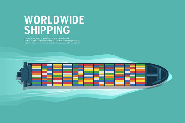
Cargo ship Top view full of standard shipping containers, container ship, cargo ship deck, transport ,Worldwide shipping conceptual vector illustration.
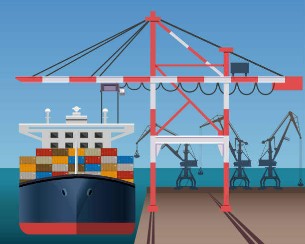
Sea cargo port with container ship and cranes. Vector illustration

Cape Route vs Suez Canal for container shipping, political map. Differences of the two main waterways and transport routes from Singapore to Rotterdam through Suez Canal or around Cape of Good Hope.

detailed seaport from above
Gantry crane icon for industry work icon.