
Illustrations
nova scotia maphalifaxnew brunswickprince edward islandnewfoundlandhalifax nova scotianova scotia flagsydney nova scotianova scotia canadanova scotia lobsterlunenburg nova scotianova scotia winternova scotia lighthousedartmouth nova scotianova scotia coastnova scotia landscapecabot trail nova scotianova scotia beachnova scotia housesnova scotia roadsnova scotia peoplenova scotia roadmap of nova scotianova scotia aerialyarmouth nova scotianova scotia tartanannapolis valley nova scotianova scotia forestnorthern nova scotianova scotia skyline
Browse 1,000+ nova scotia stock illustrations and vector graphics available royalty-free, or search for nova scotia map or halifax to find more great stock images and vector art.


vector illustration of Nova Scotia map
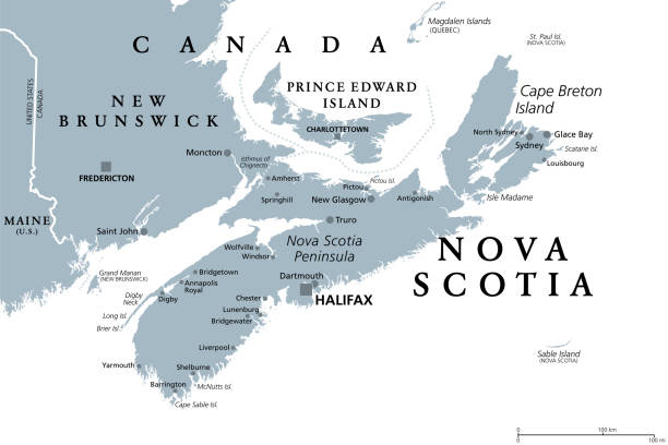
Nova Scotia, Maritime and Atlantic province of Canada, gray political map. Cape Breton Island and Nova Scotia Peninsula, with capital Halifax. Bordering on the Gulf of Maine and on the Atlantic Ocean.

Nova Scotia tartan pattern.


Nova Scotia, Maritime and Atlantic province of Canada, political map. Cape Breton Island and Nova Scotia Peninsula, with capital Halifax. Borders on the Bay of Fundy, Gulf of Maine and Atlantic Ocean.

Vector color editable map of Atlantic provinces of Canada New Brunswick, Nova Scotia, Prince Edward Island and province of Newfoundland with capitals, national borders, cities and towns, rivers and lakes. Vector EPS-10 file

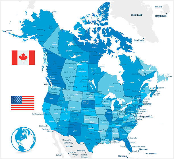
USA and Canada large detailed political map in colors of blue

Map from the Complete Handy Atlas of the World - 1898
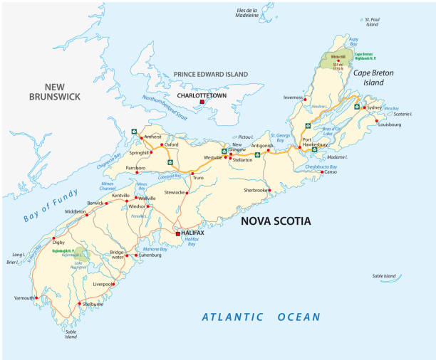
Nova Scotia road vector map, Canada.
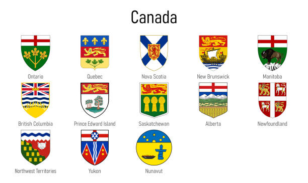
Coat of arms of the provinces of Canada, All Canadian regions emblem collection

Canadian provinces and territories map vector illustration
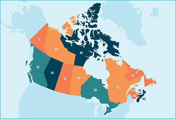
Colorful stylized vector map of Canada with labeled provinces and territory name abbreviations. All provinces and territories can be individually selected.

Map of Nova Scotia with tartan pattern.


Nova Scotia Map Network Mesh. Global Colors used, so you can easily change the base colors with just a few clicks. The colors in the .eps-file are in RGB. Transparencies used. Included files are EPS (v10) and Hi-Res JPG (3472 x 3472 px).


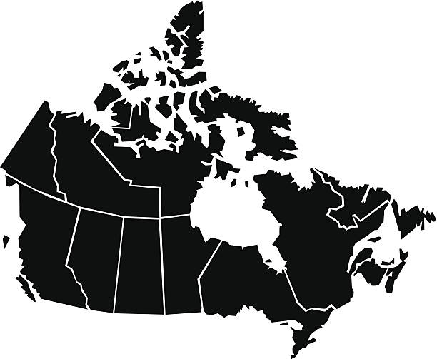
Vector isolated illustration of simplified administrative map of Canada. Borders of the provinces (regions). Grey silhouettes. White outline.


Canada Political Map with capital Ottawa, national borders, important cities, rivers and lakes. English labeling and scaling. Illustration.
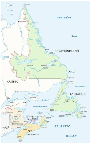
Vector map of the four canada atlantic provinces

High Quality map of Nova Scotia is a province of Canada, with borders of the counties
Detailed map of administrative divisions of Canada;


Emblem of Nova Scotia, province of Canada. Vector illustration

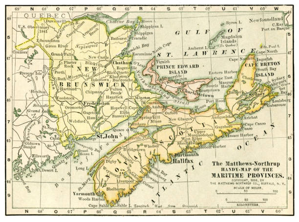
19th century map of Nova Scotia, New Brunswick. Published in New Dollar Atlas of the United States and Dominion of Canada. (Rand McNally & Co's, Chicago, 1884).

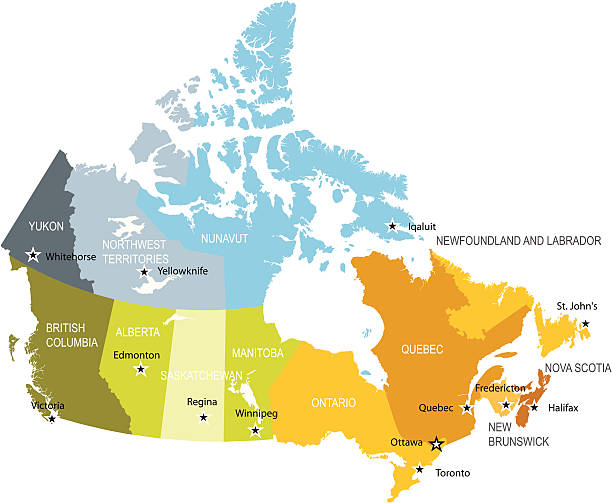
Canada, administrative divisions, political map. The ten provinces and three territories of Canada, with their borders and capitals. Country in North America, and second largest country of the world.

Map of Nova Scotia isolated on a blank background with a black outline and shadow. Vector Illustration (EPS file, well layered and grouped). Easy to edit, manipulate, resize or colorize. Vector and Jpeg file of different sizes.

Vintage engraving showing Halifax, Nova Scotia in the 19th Century

Vintage illustration Old Map of Nova Nova Scotia and New Brunswick, Prince Edward Island, detail of Halifax, 1890s, 19th Century

Map of Nova Scotia created with round blue dots on a blank background. Modern and trendy mosaic illustration. Vector Illustration (EPS10, well layered and grouped). Easy to edit, manipulate, resize or colorize.


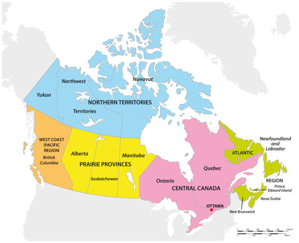
The Maritimes, the Maritime provinces of Canada, multi colored map. Region of Eastern Canada, consisting of the three provinces New Brunswick, Nova Scotia, and Prince Edward Island. Isolated. Vector


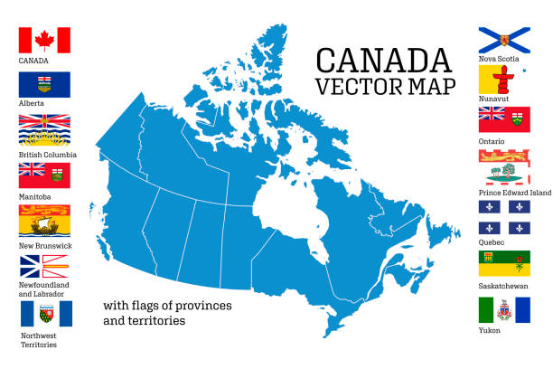
Vector illustration of a Canada and Provincial Flags set on white background. Fully editable. Includes vector eps and high resolution jpg. Includes Canada maple leaf flag, Newfoundland and Labrador, Ontario, Manitoba, Nova Scotia, Quebec, Prince Edward Island, Saskatchewan, British Columbia, Alberta, New Brunswick, NW Territories, Nunavut and Yukon.

Cornell's Grammar School Geography By S.S. Cornell - New York 1869


New Brunswick, Maritime and Atlantic province of Canada, political map. Bordered to Quebec, Nova Scotia, Gulf of St. Lawrence, Bay of Fundy and US state Maine, with capital Fredericton. Illustration.

Vintage map of the Maritime Provinces of Canada. Vintage etching circa late 19th century.

An overhead led sign thanking the work of truck drivers.

Watercolor and ink style illustration of the picturesque harbor of Peggy's Cove.

Canada, administrative divisions, colored political map. Ten provinces and three territories of Canada, with borders and capitals. Country in North America, and second largest country of the world.

Acadia Isthmus Map, Canada. Illustration published 1895. Copyright expired; artwork is in Public Domain.


Detailed Outline Map of Nova Scotia Canada

Detailed vector map of the Province and Flag. Province is it's own shape and can be coloured to your own preference. All elements are in separate layers, very easy to edit.

Vector linear illustration of a postage stamp with lighthouse isolated on white background. Travel concept with Peggy's Cove landmark image perfect for postcards. Editable stroke

Halifax and Fredericton canadian cities plates and travel stickers, vector tin signs. Canada tourist luggage tags with provinces or regions flags, emblems and Canadian landmarks

Nova Scotia Canada Map in grey

Vector set. Map of Canada with provinces and territories borders and vector flags.
Chunky,cartoon map of Canada.

vector illustration of Nova Scotia map
of18Next