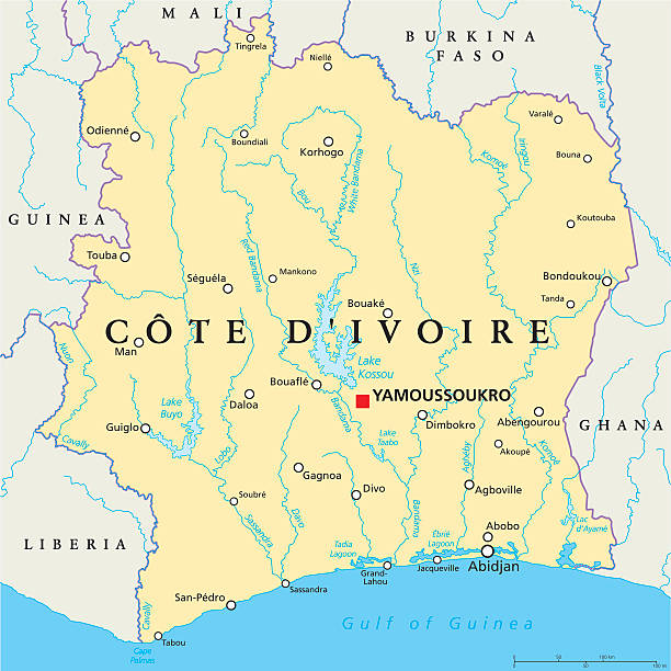
Cote D'Ivoire Political Map with capital Yamoussoukro, national borders, important cities, rivers and lakes. English labeling and scaling. Illustration.
Browse 1,000+ yamoussoukro stock illustrations and vector graphics available royalty-free, or search for ivory coast or abidjan to find more great stock images and vector art.
Cote D'Ivoire Political Map with capital Yamoussoukro, national borders, important cities, rivers and lakes. English labeling and scaling. Illustration.

World map in perspective showing the location of the country Ivory Coast with detailed map with flag of Ivory Coast. Vector illustration.

flag, country, culture, background, vector

National Flag of Ivory Coast original size and colors vector illustration, drapeau de la Cote dIvoire, Republic of Ivory Coast flag. Vector illustration

Magnifying glass showing a map of Ivory Coast on a world map. Ivory Coast flag and map enlarge in lens. Vector Illustration.

Yamoussoukro Linear City Skyline, Ivory Coast

Ivory Coast detailed map with regions and cities of the country. Vector illustration

Vector flag of Cote d'Ivoire. Proportion 2:3. Ivorian national flag. Republic of Côte d'Ivoire. Vector EPS 10

Ivory Coast flag with brush paint textured isolated on white background. Vector illustration EPS10

Côte d'Ivoire (Ivory Coast) national flag icon in the correct aspect ratio. File is built in the CMYK color space for optimal printing, and can easily be converted to RGB without any color shifts.

Ivory Coast map. Poster with map of the country in retro color palette. Shape of Ivory Coast with sunburst rays background. Vector illustration.

Outline map of Ivory Coast with the national flag imposed at its contour
Flags of Cote d'Ivoire - flat collection. Flags of different shaped twelve flat icons. Vector illustration set

Map of Ivory Coast isolated on realistic grunge canvas texture.

Map of Ivory Coast isolated on a blank background with a black outline and shadow. Vector Illustration (EPS file, well layered and grouped). Easy to edit, manipulate, resize or colorize. Vector and Jpeg file of different sizes.

Ivory Coast - set of country flags in the form of stickers of various shapes. Vector illustration

Ivory Coast polygonal triangle grey and silver vector map
Ivory Coast - Flag Pin Flat Icon. Vector Illustration

Vector isolated illustration of simplified administrative map Ivory Coast (Cote d'Ivoire). Borders of the counties. Grey silhouettes and white outline. White background

http://dikobraz.org/map_2.jpg

Crossed and waving flags of Republic of Ivory Coast and Algeria. Vector illustration

flag, country, culture, background, vector

Isometric paper map of Ivory Coast with triangular flag of Ivory Coast in isometric style. Map on topographic background. Vector illustration.

flag, country, culture, background, vector

Shape of Ivory Coast, polygonal sunburst. Map of the country with colorful star rays. Ivory Coast illustration in digital, technology, internet, network style. Vector illustration.

Crossed and waving flags of Republic of Ivory Coast and Spain. Vector illustration

Crossed flags of Luxembourg and Republic of Ivory Coast. Official colors. Correct proportion. Vector illustration

National coat of arms of the Republic of Cote d'Ivoire.

Map of Ivory Coast sketched and isolated on a blank background. The map is gray with a black outline. Vector Illustration (EPS file, well layered and grouped). Easy to edit, manipulate, resize or colorize. Vector and Jpeg file of different sizes.

Ivorian low poly regions. Polygonal map of Ivory Coast with regions. Geometric maps for your design. Modern vector illustration.

National coat of arms of the Republic of Cote d'Ivoire.

Flag of Cote d'Ivoire in the form of three hearts. Vector illustration on a white background. Brush strokes are drawn by hand. Independence Day.

Map of Ivory Coast for your own design. Three maps with editable stroke included in the bundle: - One black map on a white background. - One line map with only a thin black outline in a line art style (you can adjust the stroke weight as you want). - One map on a blank transparent background (for change background or texture). The layers are named to facilitate your customization. Vector Illustration (EPS file, well layered and grouped). Easy to edit, manipulate, resize or colorize. Vector and Jpeg file of different sizes.

Cote d'Ivoire administrative blue-green map with country flag and location on a globe. Vector illustration

Christian construction that draws crowds of tourists. Located in Ivory Coast. Vector art.

http://dikobraz.org/map_2.jpg

Crossed flags of Tajikistan and Republic of Ivory Coast. Official colors. Correct proportion. Vector illustration

Crossed and waving flags of Ivory Coast and The State of Tennessee. Vector illustration

Crossed flags of Republic of Ivory Coast and the Republic of Zambia. Official colors. Correct proportion. Vector illustration

Crossed and waving flags of Mali and Republic of Ivory Coast. Vector illustration

Crossed and waving flags of Tunisia and Republic of Ivory Coast. Vector illustration

Crossed and waving flags of Malta and Republic of Ivory Coast. Vector illustration

Crossed flags of Bahrain and Republic of Ivory Coast. Official colors. Correct proportion. Vector illustration

Crossed and waving flags of Hong Kong and Republic of Ivory Coast. Vector illustration

Crossed flags of Oman and Republic of Ivory Coast. Official colors. Correct proportion. Vector illustration

Crossed and waving flags of Slovakia and Republic of Ivory Coast. Vector illustration

Crossed and waving flags of Botswana and Republic of Ivory Coast. Vector illustration

Crossed and waving flags of the Gambia and Republic of Ivory Coast. Vector illustration

Two versions of the map of Ivory Coast, with the flag of Ivory Coast and highlighted in dark grey. Vector map.
© 2025 iStockphoto LP. The iStock design is a trademark of iStockphoto LP. Browse millions of high-quality stock photos, illustrations, and videos.
Do Not Sell or Share


