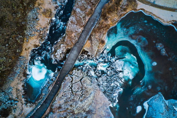
A freezing river passing under a bridge in the Pingvellir National Park, Iceland
Browse 60+ aerial view of thingvellir national park in iceland stock photos and images available, or start a new search to explore more stock photos and images.
A freezing river passing under a bridge in the Pingvellir National Park, Iceland

Silfra fissure crack between two continents in Iceland, Green algae and moss surrounding a happy snorkeler swimming on his back, relaxing in the glacial water

Aerial view of Lake Thingvellir, Mid Atlantic Ridge, Iceland.

Aerial panorama of lakes and mountains in Thingvellir National Park, Iceland.

Aerial view of lakes and mountains in Thingvellir National Park, Iceland.

Pingvellir National Park in South Central Iceland. The Parliament Building in the centre.

Aerial view of Thingvellir national park in winter, Iceland

Aerial view of lava and moss on the shoreline of Lake Thingvellir and Oxara River, Mid Atlantic Ridge, Thingvellir National Park, Unesco World heritage Site, Iceland.

Aerial view of lava and moss on the shoreline of Lake Thingvellir and Oxara River, Mid Atlantic Ridge, Thingvellir National Park, Unesco World heritage Site, Iceland.

thingvellir national park landscape in iceland, drone point of view.

country road in thingvellir national park landscape in iceland, drone point of view.

Nordic countries. Thingvellir National Park on a cloudy day, aerial view, Iceland. Europe

Aerial view of lava and moss on the shoreline of Lake Thingvellir and Oxara River, Mid Atlantic Ridge, Thingvellir National Park, Unesco World heritage Site, Iceland.

Lava and moss on the shoreline of Lake Thingvellir and Oxara River, Thingvellir National Park, Mid Atlantic Ridge, Unesco World heritage Site, Iceland.

Thingvellir is a national park in southwestern Iceland, about 40 km northeast of Iceland's capital, Reykjavik. Thngvellir is a site of historical, cultural, and geological significance, and is one of the most popular tourist destinations in Iceland. The park lies in a rift valley that marks the crest of the Mid-Atlantic Ridge and the boundary between the North American and Eurasian tectonic plates. To its south lies Tingvallavatn, the largest natural lake in Iceland. Thingvellir National Park was founded in 1930, marking the 1000th anniversary of the Althing. The park was later expanded to protect the diverse and natural phenomena in the surrounding area, and was designated as a World Heritage Site in 2004. Image taken with a drone.

Thingvellir is a national park in southwestern Iceland, about 40 km northeast of Iceland's capital, Reykjavik. Thngvellir is a site of historical, cultural, and geological significance, and is one of the most popular tourist destinations in Iceland. The park lies in a rift valley that marks the crest of the Mid-Atlantic Ridge and the boundary between the North American and Eurasian tectonic plates. To its south lies Tingvallavatn, the largest natural lake in Iceland. Thingvellir National Park was founded in 1930, marking the 1000th anniversary of the Althing. The park was later expanded to protect the diverse and natural phenomena in the surrounding area, and was designated as a World Heritage Site in 2004. Image taken with a drone.

Thingvellir is a national park in southwestern Iceland, about 40 km northeast of Iceland's capital, Reykjavik. Thngvellir is a site of historical, cultural, and geological significance, and is one of the most popular tourist destinations in Iceland. The park lies in a rift valley that marks the crest of the Mid-Atlantic Ridge and the boundary between the North American and Eurasian tectonic plates. To its south lies Tingvallavatn, the largest natural lake in Iceland. Thingvellir National Park was founded in 1930, marking the 1000th anniversary of the Althing. The park was later expanded to protect the diverse and natural phenomena in the surrounding area, and was designated as a World Heritage Site in 2004. Image taken with a drone.

thingvellir national park in iceland, drone point of view.

thingvellir national park in iceland, drone point of view.

bridge at thingvellir national park in iceland, drone point of view.

thingvellir national park in iceland, drone point of view.

thingvellir national park in iceland, drone point of view.

Thingvellir National Park in Iceland Golden circle and small waterfall landscape below called drekkingarhylur

Aerial view of Lake Thingvellir, Mid Atlantic Ridge, Iceland.

country road to the lake at pingvellir national park in south iceland. drone point of view.

Aerial view of lava and moss on the shoreline of Lake Thingvellir and Oxara River, Mid Atlantic Ridge, Thingvellir National Park, Unesco World heritage Site, Iceland.

thingvellir national park in iceland, drone point of view.

thingvellir national park landscape in iceland, drone point of view.country road in thingvellir national park landscape in iceland, drone point of view.

beautiful landscape in thingvellir national park , southern iceland, drone point of view.

country road in thingvellir national park landscape in iceland, drone point of view.

thingvellir national park landscape in iceland, drone point of view.

beautiful landscape in thingvellir national park , southern iceland, drone point of view.

Woman in red jacked at waterfall in Thingvellir National Park, Iceland.

Aerial view of Lake Thingvellir, Mid Atlantic Ridge, Iceland.

Aerial view of lava and moss on the shoreline of Lake Thingvellir and Oxara River, Mid Atlantic Ridge, Thingvellir National Park, Unesco World heritage Site, Iceland.

Islands on Lake Thingvellir, Mid Atlantic Ridge, Iceland viewed from directly above.

Aerial view of a small island on the shoreline of Lake Thingvellir and Oxara River, Mid Atlantic Ridge, Thingvellir National Park, Unesco World heritage Site, Iceland.

Aerial view of lava and moss on the shoreline of Lake Thingvellir and Oxara River, Mid Atlantic Ridge, Thingvellir National Park, Unesco World Heritage Site, Iceland.

Woman in red jacked at waterfall in Thingvellir National Park, Iceland.


