vector map of Canary Islands
Browse 1,500+ canary islands map stock photos and images available, or start a new search to explore more stock photos and images.
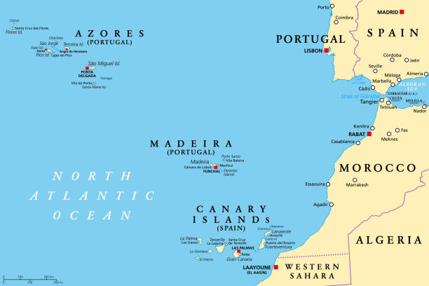
Azores, Madeira, and Canary Islands, political map. Autonomous regions of Portugal and Spain, archipelagos of volcanic islands, in the Macaronesia region of North Atlantic ocean, next to North Africa.

Canary Islands map vector illustration, scribble sketch Canary Islands
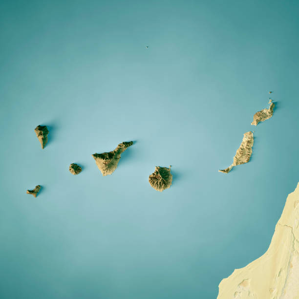
3D Render of a Topographic Map of the Canary Islands, Tenerife, Fuerteventura, Gran Canaria, Lanzarote, La Palma, La Gomera and El Hierro. All source data is in the public domain. Color and Water texture: Contains modified Copernicus Sentinel data courtesy of ESA. URL of source image: https://dataspace.copernicus.eu/explore-data/data-collections/sentinel-data/sentinel-2 Relief texture: SRTM data courtesy of NASA JPL (2020). URL of source image: https://lpdaac.usgs.gov/products/srtmgl1v003/
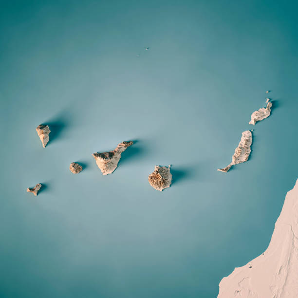
3D Render of a Topographic Map of the Canary Islands, Spain. All source data is in the public domain. Relief texture and Rivers: SRTM data courtesy of USGS. URL of source image: https://e4ftl01.cr.usgs.gov//MODV6_Dal_D/SRTM/SRTMGL1.003/2000.02.11/ Water texture: SRTM Water Body SWDB: https://dds.cr.usgs.gov/srtm/version2_1/SWBD/

White map of Canary Islands isolated on a gray background with a long shadow effect and in a flat design style. Vector Illustration (EPS10, well layered and grouped). Easy to edit, manipulate, resize or colorize.
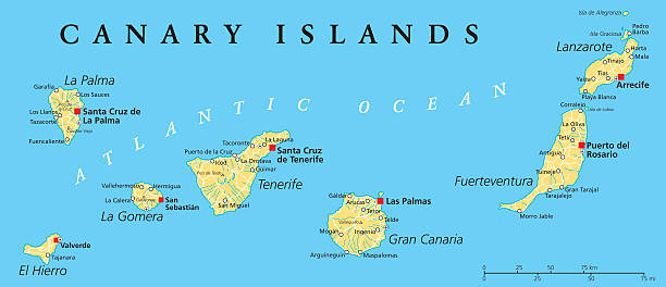
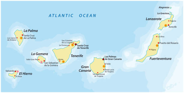
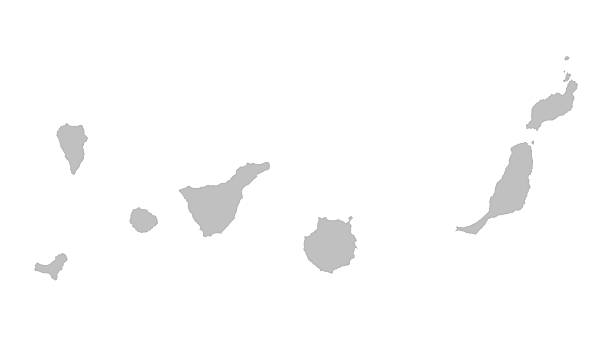
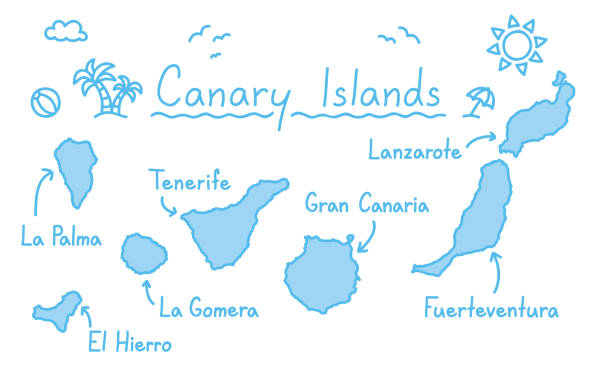
Canary Islands Political Map with Lanzarote, Fuerteventura, Gran Canaria, Tenerife, La Gomera, La Palma and El Hierro. English labeling and scaling. Illustration.

Canary Islands political map with capitals Las Palmas and Santa Cruz. The Canaries are an archipelago and autonomous community of Spain in Atlantic Ocean. Gray illustration, English labeling. Vector.

Canary Islands, Spain map.Source: "World reference atlas".
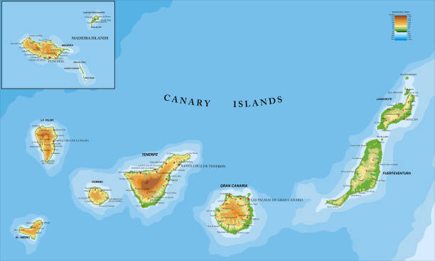
Highly detailed physical map of the Canary and Madeira islands ,in vector format,with all the relief forms,regions and big cities.

gradient Canary Islands map- vector illustration
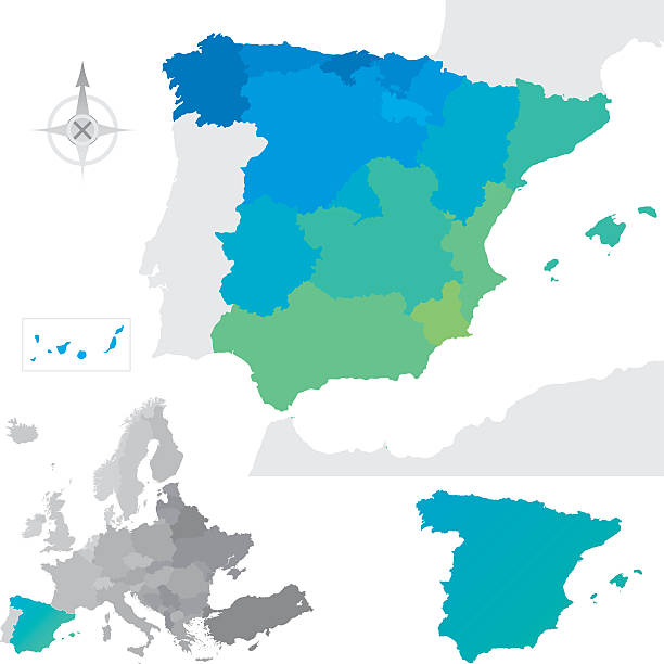
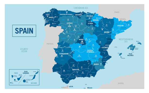
Provinces and communities of Spain. Global colours are easily changed.

Canary Islands, political map. The Canaries. La Palma, La Gomera, El Hierro, Tenerife, Gran Canaria, Fuerteventura and Lanzarote. Autonomous community of Spain, and archipelago in the Atlantic Ocean.
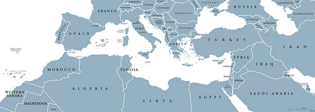
Mediterranean Basin political map. Mediterranean region, also Mediterranea. Lands around Mediterranean Sea. South Europe, North Africa and Near East. Gray illustration with English labeling. Vector.

Map of the Canary Islands. Vector illustration. World map

Map of Canary Islands for your own design. With space for your text and your background. Four maps included in the bundle: - One black map. - One blank map with only a thin black outline (in a line art style). - One mosaic map. - One white map with a thin black outline. The 4 maps are isolated on a blank background (for easy change background or texture).The layers are named to facilitate your customization. Vector Illustration (EPS10, well layered and grouped). Easy to edit, manipulate, resize or colorize.
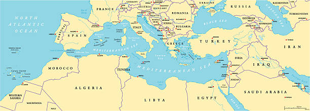
Mediterranean Basin Political Map. South Europe, North Africa and Near East with capitals, national borders, rivers and lakes. English labeling and scaling. Illustration.

Canary Islands administrative map isolated on white background, Spain

Canary Islands Map infographics vector template with abstract geometric mesh polygonal light concept on blue background. Template for diagram, graph, presentation and chart. Vector illustration EPS10

3D Render of a Topographic Map of the Canary Islands, Spain. All source data is in the public domain. Color texture: Made with Natural Earth. http://www.naturalearthdata.com/downloads/10m-raster-data/10m-cross-blend-hypso/ Relief texture and Rivers: SRTM data courtesy of USGS. URL of source image: https://e4ftl01.cr.usgs.gov//MODV6_Dal_D/SRTM/SRTMGL1.003/2000.02.11/ Water texture: SRTM Water Body SWDB: https://dds.cr.usgs.gov/srtm/version2_1/SWBD/

Canary Islands Map radial dotted pattern in futuristic style, design blue circle glowing outline made of stars. concept of communication on dark blue background. Vector illustration EPS10

Spain map icon. Black Map of Spain on White Background. Vector illustration

Macaronesia political map. Azores, Cape Verde, Madeira, Canary Islands. Collection of archipelagos in the Atlantic Ocean off the coast of Africa. English labeling. Gray illustration over white. Vector

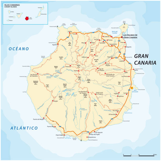
Detailed vector map of the Canary Islands, Spain, including main cities, roads, rivers and lakes. The colors in the .eps-file are ready for print (CMYK). Included files are EPS (v10) and Hi-Res JPG (4922 x 4922 px).

Azores, Madeira, and Canary Islands, gray political map. Autonomous regions of Portugal and Spain, archipelagos of volcanic islands in Macaronesia Region of North Atlantic Ocean, next to North Africa.

Photo of pinned Santa Cruz de Tenerife on a map of Africa. May be used as illustration for traveling theme.

Business map of Canary Islands modern design with abstract digital technology mesh polygonal shapes on dark blue background. Vector Illustration EPS10

Map of Canary Islands in a trendy vintage style. Beautiful retro illustration with old textured paper and light rays in the background (colors used: blue, green, beige and black for the outline). Vector Illustration (EPS10, well layered and grouped). Easy to edit, manipulate, resize or colorize.

Northern Africa, subregion, political map with single countries and international borders. Group of Mediterranean countries on the African continent geoscheme. Illustration on white background. Vector

Abstract vector color map of Canary Islands with transparent paint effect. For colorful presentation isolated on white.
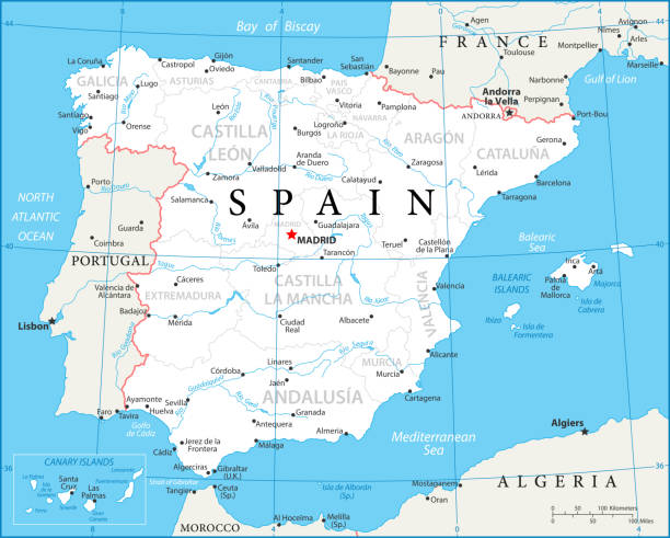
Map of Spain - Vector illustration

Vector Topographic Map of Gran Canaria Island, Canary Islands, Atlantic Ocean.
Canary islands map hand drawing doodle outline blue isolated travelling concept vector

Blackboard with a the map of the Canary Islands drawn in the middle.

3D map of Canary Islands (Islas Canarias) - black, red, blue and green - vector illustration

Grunge map of the Canary Islands printed on an old paper.
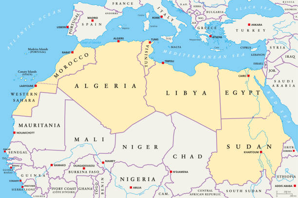
North Africa region, political map. Yellow colored area, with capitals and borders. Collective term for a group of Mediterranean countries on African continent. English labeling. Illustration. Vector.

Canary Islands of Spain map symbol shape, travel web flat vector illustration .

Map of Canary Islands created with round blue dots on a blank background. Modern and trendy mosaic illustration. Vector Illustration (EPS10, well layered and grouped). Easy to edit, manipulate, resize or colorize.

Detailed Hand traced map of Spain. Map includes Main roadways,waterways, as well as city and Capital Markers.

Map of Canary Islands with a realistic paper cut effect isolated on white background. Vector Illustration (EPS10, well layered and grouped). Easy to edit, manipulate, resize or colorize.

Map of Canary Islands cut out on a blank white paper with a blue background. Modern and trendy paper cutout effect. Vector Illustration (EPS file, well layered and grouped). Easy to edit, manipulate, resize or colorize. Vector and Jpeg file of different sizes.

3d Spain blue map on white isolated

Map of Canary Islands in a trendy vintage style. Beautiful retro illustration with old textured paper (colors used: blue, green, beige and red). Vector Illustration (EPS10, well layered and grouped). Easy to edit, manipulate, resize or colorize. Vector and Jpeg file of different sizes.

Map of Spain - Infographic Vector illustration

Canary Islands, outline map isolated on white background, Spain

3D Render of a Topographic Map Model of Gran Canaria Island, Canary Islands, Atlantic Ocean. Exaggerated Elevation.

Map of Canary Islands sketched and isolated on a blank background. The map is gray with a black outline. Vector Illustration (EPS file, well layered and grouped). Easy to edit, manipulate, resize or colorize. Vector and Jpeg file of different sizes.

White map of Canary Islands isolated on a blue background with a long shadow effect and in a flat design style. Vector Illustration (EPS10, well layered and grouped). Easy to edit, manipulate, resize or colorize.