Petrified Forest National Park
Browse 530+ chinle formation photos stock photos and images available, or start a new search to explore more stock photos and images.
Petrified Forest National Park
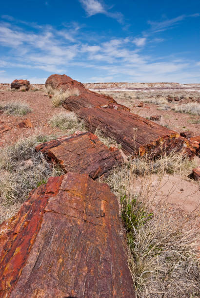
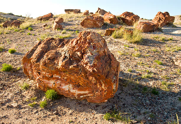
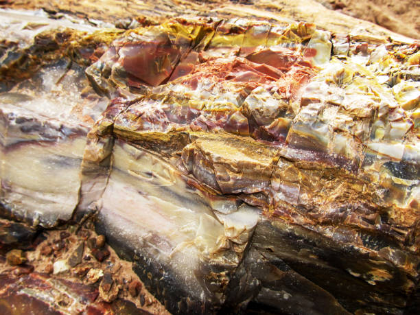
Petrified wood is formed when dead trees are buried by layers of sediment. The logs soak up groundwater and silica from volcanic ash and over time are crystallized into quartz. Different minerals create the colors seen in the logs. These petrified logs are at the Rainbow Forest in Petrified Forest National Park near Holbrook, Arizona, USA.
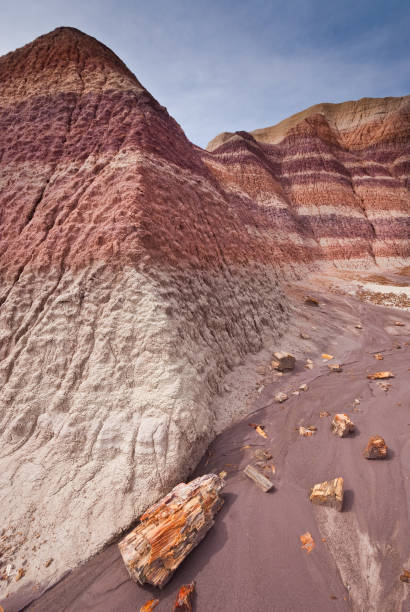
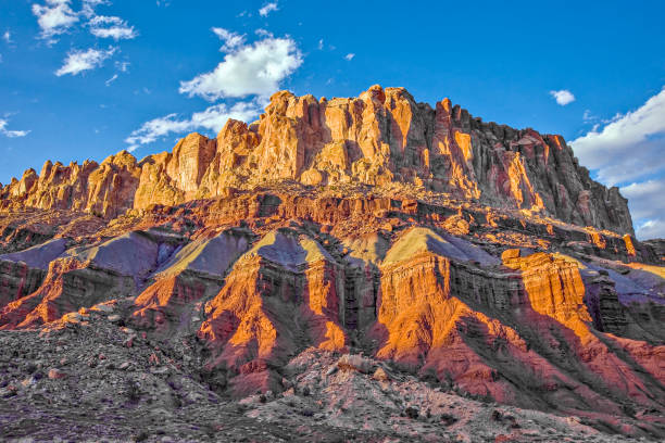
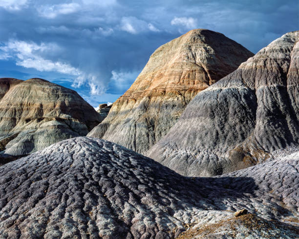
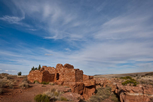
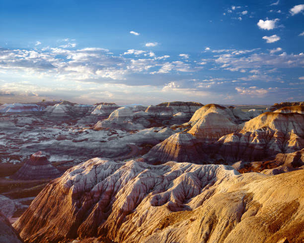
Badlands are a particular type of rock formation found in arid regions around the world. These formations require poorly consolidated rock and infrequent but torrential rain. The soft rock allows large quantities of water to channel down gullies, carrying away sediment. Bentonite clay within these formations can swell up with moisture. As the clay dries it shrinks and cracks, creating a surface resembling the skin of an elephant. Beneath the surface, an intricate maze of natural pipes and spaces form within the badlands. This hidden plumbing appears on the face of the badlands as dimples, sinks, slumps and seeps. As erosion continues, new features including caves and natural bridges can form. Badlands often take on varied colors giving the formations a banded appearance. These colorful badland formations were at Blue Mesa in Petrified Forest National Park near Holbrook, Arizona, USA.
Close-up view of the colorful petrified wood samples in the Petrified Forest state park, Escalante, Utah, USA. This sample were viewed on the Sleeping rainbow trial. It was part of a conifer which were caught in a flood during the upper Triassic epoch. During the petrifying process the cellulous were replaced by Bentonite clays, derived from volcanic ash, which gave it its spectacular colors. Legend says that you will be cursed if you remove a piece of fossilized wood from the area.
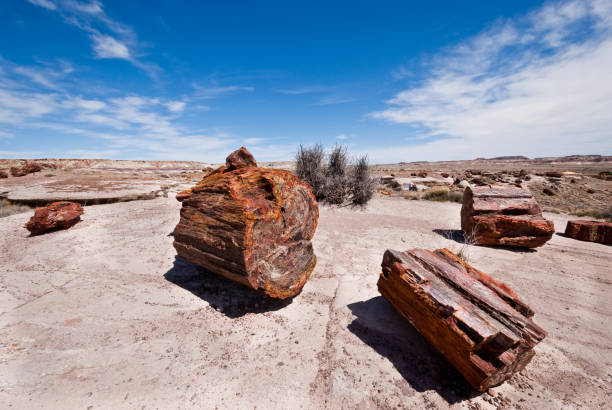
Petrified wood is formed when dead trees are buried by layers of sediment. The logs soak up groundwater and silica from volcanic ash and over time are crystallized into quartz. Different minerals create the colors seen in the logs. These petrified logs are at the Rainbow Forest in Petrified Forest National Park near Holbrook, Arizona, USA.
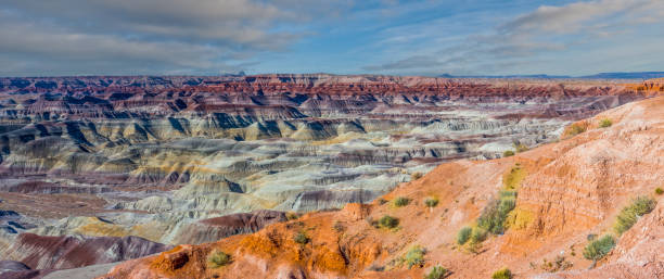
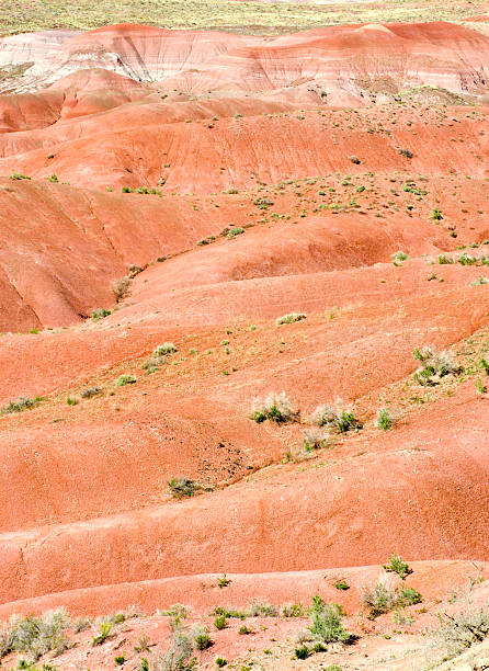
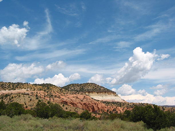
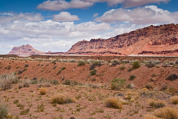
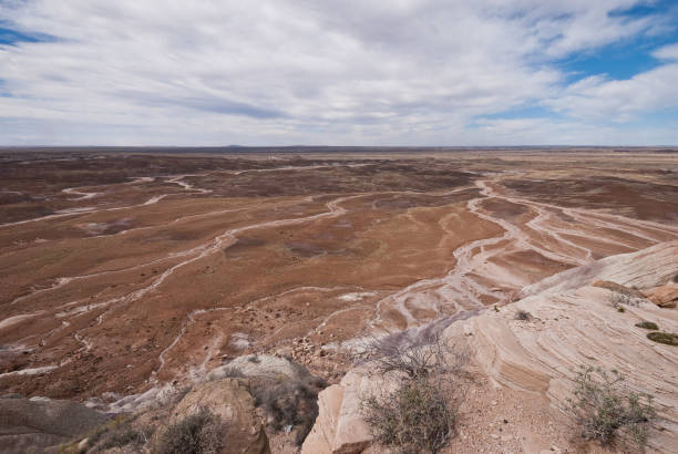
The Painted Desert is an interesting and colorful part of Northern Arizona. It starts south of Holbrook and extends about 120 miles north almost to the Utah border. It encompasses about 7,500 square miles of the Colorado Plateau. The area is made up of colorful mudstone and sandstone known as the Chinle Formation. The rocks of the Chinle Formation were deposited from 227 to 205 million years ago during the Triassic Period. Over the next 180 million years the rocks were buried, uplifted and then eroded into the present-day badland topography. This photograph of the Painted Desert was taken from Little Painted Desert County Park near Winslow, Arizona, USA.
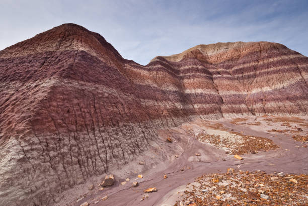
Badlands are a particular type of rock formation found in arid regions around the world. These formations require poorly consolidated rock and infrequent but torrential rain. The soft rock allows large quantities of water to channel down gullies, carrying away sediment. Bentonite clay within these formations can swell up with moisture. As the clay dries it shrinks and cracks, creating a surface resembling the skin of an elephant. Beneath the surface, an intricate maze of natural pipes and spaces form within the badlands. This hidden plumbing appears on the face of the badlands as dimples, sinks, slumps and seeps. As erosion continues, new features including caves and natural bridges can form. Badlands often take on varied colors giving the formations a banded appearance. These colorful badland formations were at Blue Mesa in Petrified Forest National Park near Holbrook, Arizona, USA.
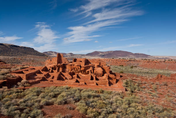
Between 1100AD and 1200AD native people inhabited the plains between the Painted Desert and the San Francisco Peaks of Arizona. In an area so dry it would seem impossible to live, they built pueblos, harvested rainwater, grew crops and raised families. Their way of life was the key to survival in this harsh landscape. These people survived here, farming one of the warmest and driest places on the Colorado Plateau. They developed the skills to farm the land and endure hardship in an area where many would not. Today the remnants of their villages dot the landscape. Wupatki Pueblo is in Wupatki National Monument, established in 1924 to preserve this rich heritage. Wupatki National Monument is near Flagstaff, Arizona, USA.
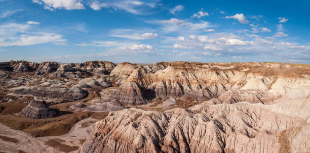
Badlands are a particular type of rock formation found in arid regions around the world. These formations require poorly consolidated rock and infrequent but torrential rain. The soft rock allows large quantities of water to channel down gullies, carrying away sediment. Bentonite clay within these formations can swell up with moisture. As the clay dries it shrinks and cracks, creating a surface resembling the skin of an elephant. Beneath the surface, an intricate maze of natural pipes and spaces form within the badlands. This hidden plumbing appears on the face of the badlands as dimples, sinks, slumps and seeps. As erosion continues, new features including caves and natural bridges can form. Badlands often take on varied colors giving the formations a banded appearance. These colorful badland formations were at Blue Mesa in Petrified Forest National Park near Holbrook, Arizona, USA.
Taken in Georgia O'Keeffe Country near Abiquiu, New Mexico in tne Carson National Forest at Echo Amphitheater.
Bureau of Land Management land near Hurricane, Utah and south of Zion National Park. American Southwest.

Sunrise Photography in Canyon De Chelley National Monument Arizona.

Drone scenic landscape near Winslow, Arizona. Colorful eroded cliffs composed of layers of siltstone, mudstone, and shale of the Triassic Chinle Formation. Dramatic Arizona landscape views, Little Painted Desert Arizona

Nearly a thousand years ago natives inhabited the plains between the Painted Desert and the San Francisco Peaks of Arizona. In an area so dry it would seem impossible to live, they built pueblos, harvested rainwater, grew crops and raised families. Today the remnants of their villages dot the landscape. Wukoki, a modern Hopi word for "Big House", was once inhabited by two or three native families. They were probably part of the Kayenta Anasazi culture and lived in this area from 1120 - 1210 AD. Their pueblo was a three story structure positioned on top of a Moenkopi Sandstone outcrop, high enough to provide great visibility of the surrounding area. Three rooms still exist today as well as an open plaza on the south side of the main building. Wupatki National Monument was established in 1924 to preserve this cultural heritage. The monument is located off US Highway 89 near Flagstaff, Arizona, USA.

The Painted Desert is an interesting and colorful part of Northern Arizona. It starts south of Holbrook and extends about 120 miles north almost to the Utah border. It encompasses about 7,500 square miles of the Colorado Plateau. The area is made up of colorful mudstone and sandstone known as the Chinle Formation. The rocks of the Chinle Formation were deposited from 227 to 205 million years ago during the Triassic Period. Over the next 180 million years the rocks were buried, uplifted and then eroded into the present-day badland topography. This photograph of the Painted Desert was taken from Little Painted Desert County Park near Winslow, Arizona, USA.

The Painted Desert is an interesting and colorful part of Northern Arizona. It starts south of Holbrook and extends about 120 miles north almost to the Utah border. It encompasses about 7,500 square miles of the Colorado Plateau. The area is made up of colorful mudstone and sandstone known as the Chinle Formation. The rocks of the Chinle Formation were deposited from 227 to 205 million years ago during the Triassic Period. Over the next 180 million years the rocks were buried, uplifted and then eroded into the present-day badland topography. This picture of the Painted Desert was taken from Kachina Point in Petrified Forest National Park near Holbrook, Arizona, USA.
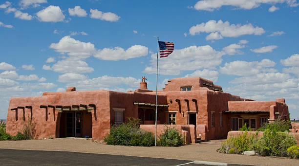
Petrified Forest, United States - September 3, 2016: The Painted Desert Inn was originally built in 1920 using petrified wood as the main construction product. At that time it was known as the Stone Tree House, for obvious reasons, but in the late 1930's the building got a complete makeover by the Civilian Conservation Corps. Since then its exterior has more of a Southwestern style of architecture with stucco walls and vegas used as support. It now functions as a museum with the Petrified Forest National Park.

The Painted Desert is an interesting and colorful part of Northern Arizona. It starts south of Holbrook and extends about 120 miles north almost to the Utah border. It encompasses about 7,500 square miles of the Colorado Plateau. The area is made up of colorful mudstone and sandstone known as the Chinle Formation. The rocks of the Chinle Formation were deposited from 227 to 205 million years ago during the Triassic Period. Over the next 180 million years the rocks were buried, uplifted and then eroded into the present-day badland topography. This photograph of the Painted Desert was taken from Little Painted Desert County Park near Winslow, Arizona, USA.

Drone scenic landscape near Winslow, Arizona. Colorful eroded cliffs composed of layers of siltstone, mudstone, and shale of the Triassic Chinle Formation. Dramatic Arizona landscape views, Little Painted Desert Arizona

Drone scenic landscape near Winslow, Arizona. Colorful eroded cliffs composed of layers of siltstone, mudstone, and shale of the Triassic Chinle Formation. Dramatic Arizona landscape views, Little Painted Desert Arizona

Badlands are a particular type of rock formation found in arid regions around the world. These formations require poorly consolidated rock and infrequent but torrential rain. The soft rock allows large quantities of water to channel down gullies, carrying away sediment. Bentonite clay within these formations can swell up with moisture. As the clay dries it shrinks and cracks, creating a surface resembling the skin of an elephant. Beneath the surface, an intricate maze of natural pipes and spaces form within the badlands. This hidden plumbing appears on the face of the badlands as dimples, sinks, slumps and seeps. As erosion continues, new features including caves and natural bridges can form. Badlands often take on varied colors giving the formations a banded appearance. These colorful badland formations were at Blue Mesa in Petrified Forest National Park near Holbrook, Arizona, USA.
Petrified Forest National Park

Petrified wood is formed when dead trees are buried by layers of sediment. The logs soak up groundwater and silica from volcanic ash and over time are crystallized into quartz. Different minerals create the colors seen in the logs. These petrified logs were photographed at sunset by the Agate House Trail in Petrified Forest National Park near Holbrook, Arizona, USA.
Echo Cliffs is a prominent 70 mile long step-like fold in the rock strata called a monocline. The Chinle Formation of the Colorado Plateau is prominently exposed in the cliffs. The rocks above are from the Glen Canyon Group and the rocks below are from the Moenkopi Formation. This view of the Echo Cliffs was photographed from US Highway 89 near The Gap, Arizona, USA.

Badlands are a particular type of rock formation found in arid regions around the world. These formations require poorly consolidated rock and infrequent but torrential rain. The soft rock allows large quantities of water to channel down gullies, carrying away sediment. Bentonite clay within these formations can swell up with moisture. As the clay dries it shrinks and cracks, creating a surface resembling the skin of an elephant. Beneath the surface, an intricate maze of natural pipes and spaces form within the badlands. This hidden plumbing appears on the face of the badlands as dimples, sinks, slumps and seeps. As erosion continues, new features including caves and natural bridges can form. Badlands often take on varied colors giving the formations a banded appearance. These colorful badland formations were at Blue Mesa in Petrified Forest National Park near Holbrook, Arizona, USA.
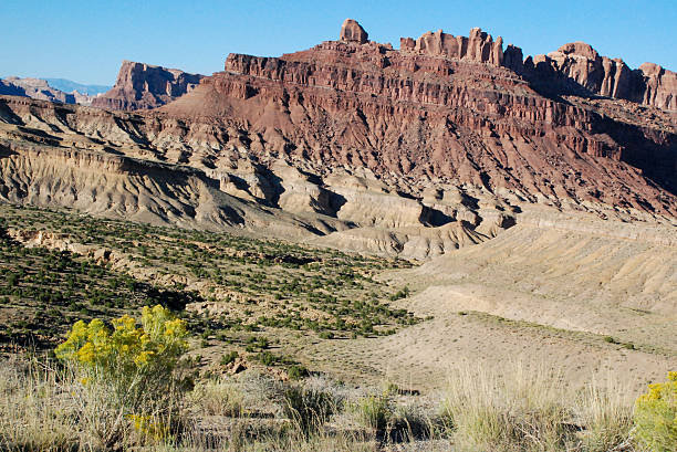
Views of San Rafael Swell and the dramatic Moss Back cliffs near Mexican Bend seen from scenic overlook off I-70 on west-bound lanes just after crossing "The Reef" with views of diverse geologic formations such as Kayenta, Chinle, Moenkopi, Sinbad, Kaibab, Wingate, Entrada

Badlands are a particular type of rock formation found in arid regions around the world. These formations require poorly consolidated rock and infrequent but torrential rain. The soft rock allows large quantities of water to channel down gullies, carrying away sediment. Bentonite clay within these formations can swell up with moisture. As the clay dries it shrinks and cracks, creating a surface resembling the skin of an elephant. Beneath the surface, an intricate maze of natural pipes and spaces form within the badlands. This hidden plumbing appears on the face of the badlands as dimples, sinks, slumps and seeps. As erosion continues, new features including caves and natural bridges can form. Badlands often take on varied colors giving the formations a banded appearance. These colorful badland formations were at Blue Mesa in Petrified Forest National Park near Holbrook, Arizona, USA.

Petrified wood is formed when dead trees are buried by layers of sediment. The logs soak up groundwater and silica from volcanic ash and over time are crystallized into quartz. Different minerals create the colors seen in the logs. These petrified logs were photographed at sunset by the Agate House Trail in Petrified Forest National Park near Holbrook, Arizona, USA.

Badlands are a particular type of rock formation found in arid regions around the world. These formations require poorly consolidated rock and infrequent but torrential rain. The soft rock allows large quantities of water to channel down gullies, carrying away sediment. Bentonite clay within these formations can swell up with moisture. As the clay dries it shrinks and cracks, creating a surface resembling the skin of an elephant. Beneath the surface, an intricate maze of natural pipes and spaces form within the badlands. This hidden plumbing appears on the face of the badlands as dimples, sinks, slumps and seeps. As erosion continues, new features including caves and natural bridges can form. Badlands often take on varied colors giving the formations a banded appearance. These colorful badland formations were at Blue Mesa in Petrified Forest National Park near Holbrook, Arizona, USA.
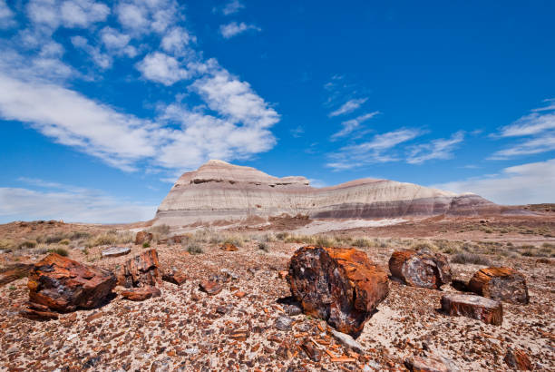
Petrified wood is formed when dead trees are buried by layers of sediment. The logs soak up groundwater and silica from volcanic ash and over time are crystallized into quartz. Different minerals create the colors seen in the logs. These petrified logs are at the Crystal Forest in Petrified Forest National Park near Holbrook, Arizona, USA.
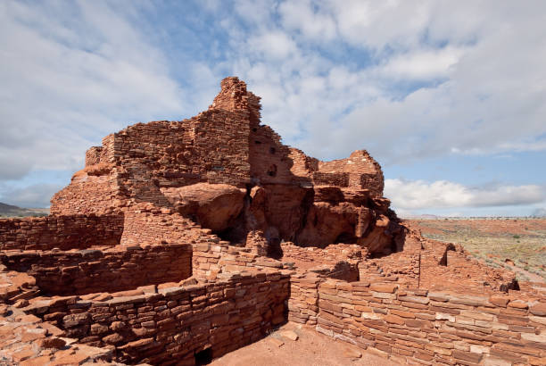
Nearly a thousand years ago natives inhabited the plains between the Painted Desert and the San Francisco Peaks of Arizona. In an area so dry it would seem impossible to live, they built pueblos, harvested rainwater, grew crops and raised families. Today the remnants of their villages dot the landscape. Wupatki Pueblo is in Wupatki National Monument, established in 1924 to preserve this rich heritage. Wupatki National Monument is near Flagstaff, Arizona, USA.
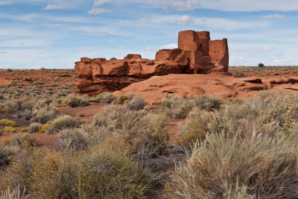
Nearly a thousand years ago natives inhabited the plains between the Painted Desert and the San Francisco Peaks of Arizona. In an area so dry it would seem impossible to live, they built pueblos, harvested rainwater, grew crops and raised families. Today the remnants of their villages dot the landscape. Wukoki, a modern Hopi word for "Big House", was once inhabited by two or three native families. They were probably part of the Kayenta Anasazi culture and lived in this area from 1120 - 1210 AD. Their pueblo was a three story structure positioned on top of a Moenkopi Sandstone outcrop, high enough to provide great visibility of the surrounding area. Three rooms still exist today as well as an open plaza on the south side of the main building. Wupatki National Monument was established in 1924 to preserve this cultural heritage. The monument is located off US Highway 89 near Flagstaff, Arizona, USA.

Nearly a thousand years ago natives inhabited the plains between the Painted Desert and the San Francisco Peaks of Arizona. In an area so dry it would seem impossible to live, they built pueblos, harvested rainwater, grew crops and raised families. Today the remnants of their villages dot the landscape. Wupatki Pueblo is in Wupatki National Monument, established in 1924 to preserve this rich heritage. Wupatki National Monument is near Flagstaff, Arizona, USA.

Echo Cliffs is a prominent 70 mile long step-like fold in the rock strata called a monocline. The Chinle Formation of the Colorado Plateau is prominently exposed in the cliffs. The rocks above are from the Glen Canyon Group and the rocks below are from the Moenkopi Formation. This view of the Echo Cliffs was photographed from US Highway 89 near The Gap, Arizona, USA.

The Painted Desert is an interesting and colorful part of Northern Arizona. It starts south of Holbrook and extends about 120 miles north almost to the Utah border. It encompasses about 7,500 square miles of the Colorado Plateau. The area is made up of colorful mudstone and sandstone known as the Chinle Formation. The rocks of the Chinle Formation were deposited from 227 to 205 million years ago during the Triassic Period. Over the next 180 million years the rocks were buried, uplifted and then eroded into the present-day badland topography. This photograph of the Painted Desert was taken from Little Painted Desert County Park near Winslow, Arizona, USA.
Badlands are a particular type of rock formation found in arid regions around the world. These formations require poorly consolidated rock and infrequent but torrential rain. The soft rock allows large quantities of water to channel down gullies, carrying away sediment. Bentonite clay within these formations can swell up with moisture. As the clay dries it shrinks and cracks, creating a surface resembling the skin of an elephant. Beneath the surface, an intricate maze of natural pipes and spaces form within the badlands. This hidden plumbing appears on the face of the badlands as dimples, sinks, slumps and seeps. As erosion continues, new features including caves and natural bridges can form. Badlands often take on varied colors giving the formations a banded appearance. These colorful badland formations were at Blue Mesa in Petrified Forest National Park near Holbrook, Arizona, USA.

The Painted Desert is an amazing topography of colorful sandstone landscapes within the Petrified Forest National Park.

The Painted Desert is an amazing topography of colorful sandstone landscapes within the Petrified Forest National Park.
Lomaki Pueblo, meaning the "Beautiful House", is located on Antelope Prairie in the plains between the Painted Desert and the San Francisco Peaks of Arizona. Nearly a thousand years ago natives inhabited this area which is so dry and windy it would seem impossible to live. It was here that they built pueblos, harvested rainwater, grew crops and raised families. Today the remnants of their villages dot the landscape. Wupatki National Monument was established in 1924 to preserve this cultural heritage. The monument is located off US Highway 89 near Flagstaff, Arizona, USA.

The Painted Desert is an interesting and colorful part of Northern Arizona. It starts south of Holbrook and extends about 120 miles north almost to the Utah border. It encompasses about 7,500 square miles of the Colorado Plateau. The area is made up of colorful mudstone and sandstone known as the Chinle Formation. The rocks of the Chinle Formation were deposited from 227 to 205 million years ago during the Triassic Period. Over the next 180 million years the rocks were buried, uplifted and then eroded into the present-day badland topography. This photograph of the Painted Desert was taken from Little Painted Desert County Park near Winslow, Arizona, USA.

The Painted Desert is an interesting and colorful part of Northern Arizona. It starts south of Holbrook and extends about 120 miles north almost to the Utah border. It encompasses about 7,500 square miles of the Colorado Plateau. The area is made up of colorful mudstone and sandstone known as the Chinle Formation. The rocks of the Chinle Formation were deposited from 227 to 205 million years ago during the Triassic Period. Over the next 180 million years the rocks were buried, uplifted and then eroded into the present-day badland topography. This photograph of the Painted Desert was taken from Little Painted Desert County Park near Winslow, Arizona, USA.

Wide shot of Spider Rock the legendary home of Spider Woman a Navajo mythological deity as seen from the south rim of Canyon de Chelly National Park.

Badlands are a particular type of rock formation found in arid regions around the world. These formations require poorly consolidated rock and infrequent but torrential rain. The soft rock allows large quantities of water to channel down gullies, carrying away sediment. Bentonite clay within these formations can swell up with moisture. As the clay dries it shrinks and cracks, creating a surface resembling the skin of an elephant. Beneath the surface, an intricate maze of natural pipes and spaces form within the badlands. This hidden plumbing appears on the face of the badlands as dimples, sinks, slumps and seeps. As erosion continues, new features including caves and natural bridges can form. Badlands often take on varied colors giving the formations a banded appearance. These colorful badland formations were at Blue Mesa in Petrified Forest National Park near Holbrook, Arizona, USA.

The Painted Desert is an interesting and colorful part of Northern Arizona. It starts south of Holbrook and extends about 120 miles north almost to the Utah border. It encompasses about 7,500 square miles of the Colorado Plateau. The area is made up of colorful mudstone and sandstone known as the Chinle Formation. The rocks of the Chinle Formation were deposited from 227 to 205 million years ago during the Triassic Period. Over the next 180 million years the rocks were buried, uplifted and then eroded into the present-day badland topography. This photograph of the Painted Desert was taken from Little Painted Desert County Park near Winslow, Arizona, USA.
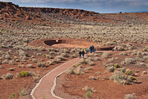
Wupatki National Monument, Arizona, USA - May 19, 2011: In addition to the dwellings at Wupatki Pueblo there is a ceremonial ball court. Pictured here are some visitors walking toward the ball court.
Petrified Forest National Park

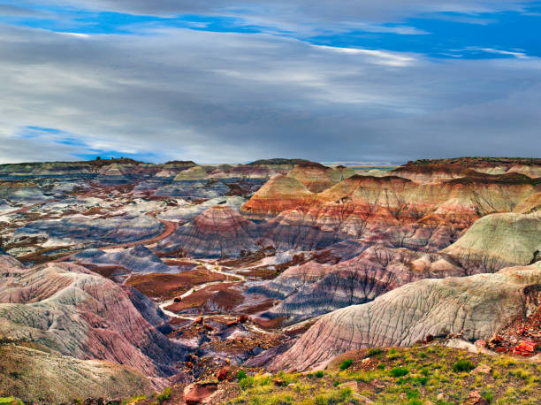
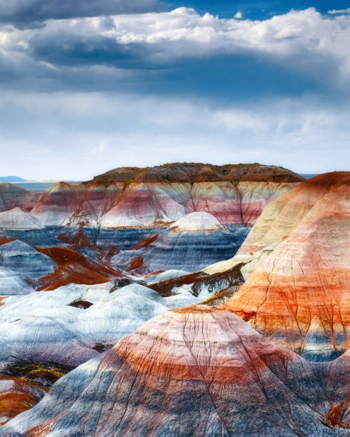
The Blue Mesa at Arizona’s Petrified Forest National Park is part of the Chinle Formation on the Colorado Plateau, known for striped mounds of clay and petrified logs.

The Painted Desert is an interesting and colorful part of Northern Arizona. It starts south of Holbrook and extends about 120 miles north almost to the Utah border. It encompasses about 7,500 square miles of the Colorado Plateau. The area is made up of colorful mudstone and sandstone known as the Chinle Formation. The rocks of the Chinle Formation were deposited from 227 to 205 million years ago during the Triassic Period. Over the next 180 million years the rocks were buried, uplifted and then eroded into the present-day badland topography. This photograph of the Painted Desert was taken from Little Painted Desert County Park near Winslow, Arizona, USA.

A large petrified log sits atop a clay mound in the Blue Mesa area of Arizona’s Petrified Forest National Park.

Sheer red cliffs rise above a tree studded green canyon floor of Canyon de Chelly National Monument as seen from Sliding House Overlook.

Echo Cliffs is a prominent 70 mile long step-like fold in the rock strata called a monocline. The Chinle Formation of the Colorado Plateau is prominently exposed in the cliffs. The rocks above are from the Glen Canyon Group and the rocks below are from the Moenkopi Formation. This view of the Echo Cliffs was photographed from US Highway 89 near The Gap, Arizona, USA.

The Painted Desert is an interesting and colorful part of Northern Arizona. It starts south of Holbrook and extends about 120 miles north almost to the Utah border. It encompasses about 7,500 square miles of the Colorado Plateau. The area is made up of colorful mudstone and sandstone known as the Chinle Formation. The rocks of the Chinle Formation were deposited from 227 to 205 million years ago during the Triassic Period. Over the next 180 million years the rocks were buried, uplifted and then eroded into the present-day badland topography. This photograph of the Painted Desert was taken from Little Painted Desert County Park near Winslow, Arizona, USA.

The Painted Desert is an interesting and colorful part of Northern Arizona. It starts south of Holbrook and extends about 120 miles north almost to the Utah border. It encompasses about 7,500 square miles of the Colorado Plateau. The area is made up of colorful mudstone and sandstone known as the Chinle Formation. The rocks of the Chinle Formation were deposited from 227 to 205 million years ago during the Triassic Period. Over the next 180 million years the rocks were buried, uplifted and then eroded into the present-day badland topography. This photograph of the Painted Desert was taken from Lacey Point in Petrified Forest National Park near Holbrook, Arizona, USA.