
Images
705 Images and Stock Photos
View columbus aerial videos
Browse 700+ columbus aerial stock photos and images available, or start a new search to explore more stock photos and images.


Aerial still image of the Discovery Bridge sitting on top of the Scioto River, taken by a drone on a clear, Fall night.
Our creative library is free of AI-generated contentChoose your visuals with confidence knowing our creative library is free from AI-generated content, so your searches only return safe, high-quality visuals you can trust.


Aerial of Columbus Ohio Skyline photograph taken August 2006

Drone view over typical North American houses, quintessence of family home in suburban areas. Perfect for showcasing family home lifestyle where Americans cherish family values American suburban life


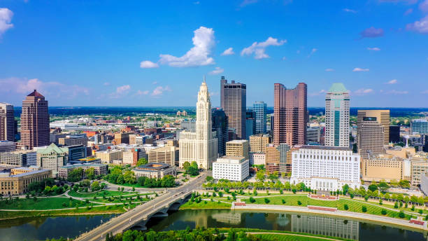
Columbus, Ohio aerial skyline panorama. Columbus is the state capital and the most populous city in the U.S. state of Ohio

Aerial still image of the Reeb-Hosack neighborhood in Columbus, Ohio, taken by a drone on a clear, Fall day.

Columbus downtown skyscrapers, aerial / elevated view. The Ohio State Capitol is located at the far left corner of the image.

Aerial of Downtown Columbus during fall / autumn with the Scioto River, Main Street Bridge, Rich Street Bridge, and Scioto Greenway parklands in the foreground.

Panoramic aerial view in Interstate 70 running through the Scioto Woods, Columbus, Ohio USA

Aerial still image of the Downtown Columbus skyline taken by a drone flying over Reeb-Hosack on a clear Fall day.


3D Render of a Topographic Map of North East Region of the United States of America. All source data is in the public domain. Color texture: Made with Natural Earth. http://www.naturalearthdata.com/downloads/10m-raster-data/10m-cross-blend-hypso/ Relief texture: GMTED2010 data courtesy of USGS. URL of source image: https://topotools.cr.usgs.gov/gmted_viewer/viewer.htm Water texture: World Water Body Limits: Humanitarian Information Unit HIU, U.S. Department of State http://geonode.state.gov/layers/geonode%3AWorld_water_body_limits_polygons Boundaries: Humanitarian Information Unit HIU, U.S. Department of State (database: LSIB) http://geonode.state.gov/layers/geonode%3ALSIB_10

Downtown Columbus skyline aerial at dusk with the Scioto River, Discovery Bridge, Genoa Park (lower third), and East Bank Park (center) in the foreground.

The Chattahoochee River separates Columbus, Georgia from Phenix City, Alabama (foreground), as shown from an aircraft on final approach to Columbus's airport.
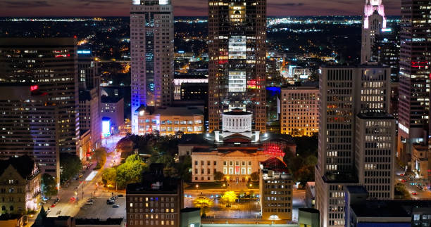
Aerial still image of the Ohio Statehouse in Downtown Columbus taken by a drone on a clear, Fall night.


Columbus, Ohio, USA - 5 August 2023: Drone view of the Ohio State Football Stadium set up for a concert early in the morning.

Aerial shot of Columbus, Ohio on a sunny evening in summer.

An aerial view of Columbus Georgia featuring tall skyscrapers, greenery, and a clear blue sky. The composition highlights urban architecture and natural elements under bright daylight, creating a harmonious cityscape.

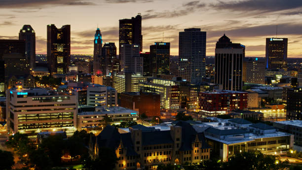
Aerial shot of Downtown Columbus after sunset, including the Ohio Statehouse.

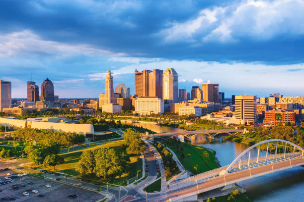
Elevated Aerial View of the Columbus, Ohio Skyline with the Battelle Riverfront Park, Scioto River, and Broad Street Bridge in the foreground.
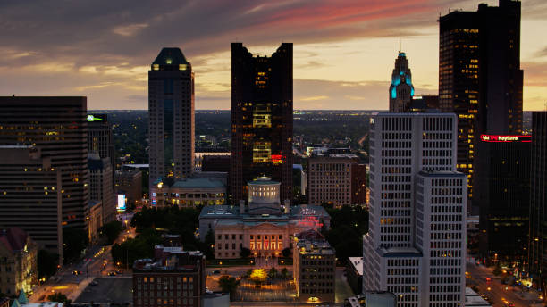
Aerial shot of Downtown Columbus after sunset, including the Ohio Statehouse.

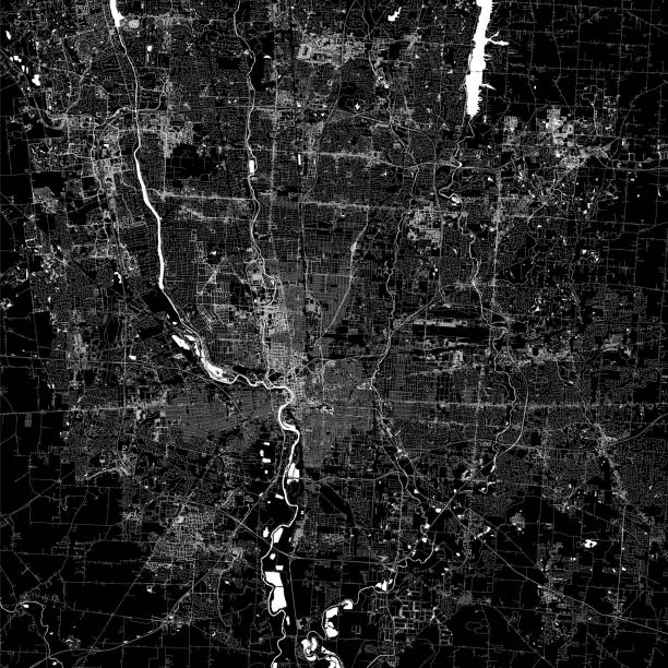
3D Render of a Topographic Map of Columbus, Ohio, USA. All source data is in the public domain. Contains modified Copernicus Sentinel data (Sept 2019) courtesy of ESA. URL of source image: https://scihub.copernicus.eu/dhus/#/home. Relief texture SRTM data courtesy of NASA. URL of source image: https://search.earthdata.nasa.gov/search/granules/collection-details?p=C1000000240-LPDAAC_ECS&q=srtm%201%20arc&ok=srtm%201%20arc Building footprint data courtesy of Microsoft. URL of source data: https://github.com/Microsoft/USBuildingFootprints National Transportation Dataset courtesy of US Geological Survey. URL of source data: https://viewer.nationalmap.gov/basic/

Image of Panorama Columbus Ohio downtown at sunrise with river aerial drone shot

Aerial perspective of Columbus, Georgia's downtown skyline featuring modern office towers, historic architecture, and dual bridges crossing the Chattahoochee River, surrounded by lush riverside parks.

Aerial still image of Downtown Columbus taken by a drone on a clear night in Ohio.


Manhattan, NYC - December 27, 2013: New York Central Park. Columbus Circle. monument to Christopher Columbus. Trump Tower.

Aerial still image of Downtown Columbus, with the Supreme Court of Ohio and Scioto River, taken by a drone on a clear, Fall night.

Aerial shot of a freeway in Columbus, Ohio with late afternoon sun shining on the Scioto River.

3D Render of a Topographic Map of Columbus, Ohio, USA. All source data is in the public domain. Contains modified Copernicus Sentinel data (Sept 2019) courtesy of ESA. URL of source image: https://scihub.copernicus.eu/dhus/#/home. Relief texture SRTM data courtesy of NASA. URL of source image: https://search.earthdata.nasa.gov/search/granules/collection-details?p=C1000000240-LPDAAC_ECS&q=srtm%201%20arc&ok=srtm%201%20arc

Image of Columbus Ohio downtown aerial with major skyscraper buildings Scioto River and bridge


"The Leveque Tower in Columbus Ohio, framed by trees on a blue sky day."
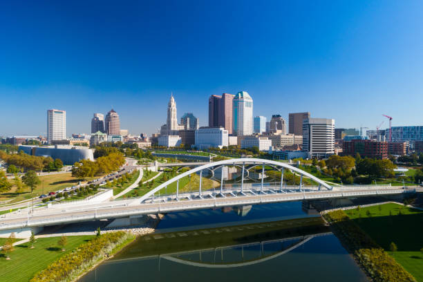
Downtown Columbus skyline aerial with a clear blue sky in the background and the Scioto River and the Main Street Bridge in the foreground.
Topographic / Road map of Columbus, OH, USA. Original map data is open data via © OpenStreetMap contributors

A panoramic view of Columbus Georgia's downtown skyline with modern buildings, a riverfront bridge, lush greenery, and a clear blue sky. The cityscape exudes a clean and vibrant urban atmosphere on a sunny day.

Aerial shot of cars on a highway in Downtown Columbus taken by a drone on a clear, Fall night in Ohio.

Aerial view in 70 highway road near Scioto Woods, Columbus, Ohio USA

Columbus, Ohio, USA - 5 August 2023: View from above Ohio Stage Stadium taken from a drone early in the morning the day of a music concert.

Aerial establishing shot of the Ohio Statehouse in Columbus at sunset.


Downtown Columbus skyline aerial with Alexander Park, Battelle Riverfront Park, Genoa Park, Scioto Park, Scioto River, and a railway bridge in the foreground.


Aerial still image of the Ohio Statehouse taken by a drone flying directly above on a clear, Fall day in Columbus, Ohio.

Image of US Bank and LeVeque Tower aerial view of tops of skyscraper buildings

Aerial shot of Columbus, Ohio on a sunny evening in summer.


Aerial still image of the Downtown Columbus skyline taken by a drone flying over Reeb-Hosack, Ohio, on a clear, Fall day.

Aerial still image of Downtown Columbus, with Discovery Bridge and East Bank Park, taken by a drone on a clear, Fall day in Ohio.
of12Next