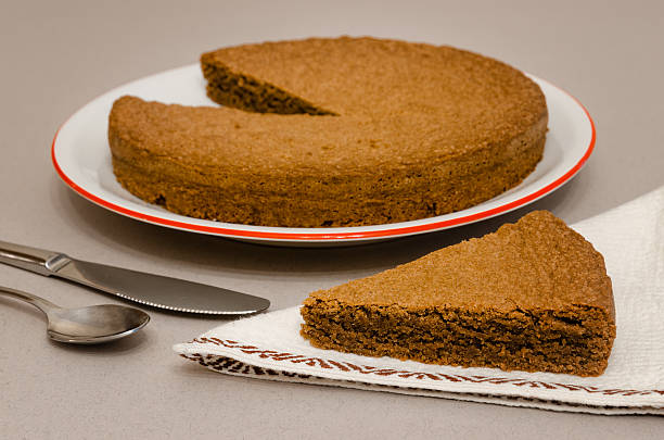
Torta di Nocciole, traditional hazelnut cake made with Nocciola Piemonte Igp (also known as Tonda Gentile di Langa), typical hazelnut variety of Piedmont, Italy
Browse 7,000+ coni stock photos and images available, or start a new search to explore more stock photos and images.
Torta di Nocciole, traditional hazelnut cake made with Nocciola Piemonte Igp (also known as Tonda Gentile di Langa), typical hazelnut variety of Piedmont, Italy

At the foot of Monviso, along the banks of the Po river, agriculture is the main source of income for the territory
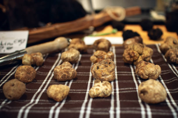
White Truffles (Tuber Magnatum Pico) on a trader stall, Piedmont (Italy)

Caraglio, Piedmont, Italy - February 02, 2024: Piazza Giolitti with the Town Hall and the parish church of Maria Vergine Assunta

With its 3841 meters of altitude, Monviso is the most loved mountain in Piedmont. Its sunsets can be admired from all over the Po Valley, from Turin to Bergamo. Since 29 May 2013 it has become a UNESCO World Heritage Site as a cross-border biosphere reserve with France

Alba, Italy - November 1, 2015: People walking in Alba (Cuneo - Italy) during International Truffle Fair. During the International white truffle fair of Alba, the truffle hunters sell their products to retailers and to the tourists in the truffle market

Saluzzo, Italy - February 3, 2023: Landscape of the medieval village with the civic tower on blue sky with white clouds
Fossano, Cuneo, Italy - February 27, 2022: Church of Holy Trinity or dei Battuti Rossi (18th century arch Francesco Gallo) in baroque style, on blue sky with cloud. Fossano is in northwestern Italy

"Little town Neive famous for winemaking in province of Cuneo, Italy. Vineyards in foreground.Vineyard of Piedmont, Italy."
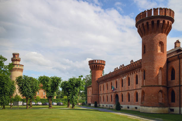
Pollenzo, Italy - June 12, 2020: Exterior view of the castle of Pollenzo, italy, on june 12 2020; also known for its university of gastronomic sciences

Grinzane Cavour, Italy - October 24, 2018: Sunset in autumn, during harvest time, at the castle of Grinzane Cavour, surrounded by the vineyards of Langhe, the most importan wine district of Italy and Unesco Heritage for its landscape

At 2700 meters of the Pagarì Refuge, in the Alta Valle Gesso it is possible to meet herds of ibex that familiarize themselves with the hikers

Fields, orchards and poplar groves in the Cuneo plain struggling with the coldest season

Racconigi, Cuneo, Piedmont, Italy - April 27, 2023: Royal Castle of Racconigi residence of the Savoy family since the 14th century, landscape with blue sky and white clouds

Cuneo, Italy, December 2020. In this image you can see a woman walking under the snow on a cold day in Cuneo (Piedmont).

This photo was taken in Prato Nevoso, Province of Cuneo, Northern Italy

View of La Morra in the Province of Cuneo, Piedmont, Italy.

Fossano, Italy - February 27, 2022: Cathedral of Santa Maria and San Giovenale (XVIII century) with the Civic bell tower (XV century) and historic buildings in via Roma

Neive village, Langhe vineyards and trees as a frame. Unesco Site, Piedmont, Northern Italy Europe.

beautiful views of the mountains of Limone Piemonte, in the Piedmontese maritime alps, during a trekking in August of the summer of 2022

Italy. Region of Piedmont. Province of Cuneo. The Vicoforte shrine. Elliptical dome with frescoes. The shrine of Vicoforte (in Italian, Santuario di Vicoforte, also known as Santuario Regina Montis Regalis) is a monumental church known for having the largest elliptical dome in the world. As the story goes, in Medieval times it was a little chapel with a fresco depicting the Virgin. One day, a huntsman named Giulio Sargiano struck this image, that began to bleed. Then the huntsman collected a large amount of money to repair the damage, and offered his arquebus to the shrine. Today this arquebus is preserved in a chapel of the sanctuary near the fresco that was disfigured. In 1596, the duke Charles Emmanuel I of Savoy commissioned the construction of a large sanctuary from the court architect Ascanio Vitozzi. However both the duke and the architect died before the building was finished. The construction was resumed in the 18th century under Francesco Gallo who built the great elliptical dome (major diameter 118 ft, minor diameter 82 ft). Mattia Bortoloni and Felice Biella painted with frescos the 64,930 square feet of the dome (1752). In 1884, four bell towers were built at the four corners of the church.

Panorama of the Colle di Tenda mountains, which separates Italy from France through an old historic road

A jewel of nature set among the rocks of one of the most beautiful mountains in the province of Cuneo

At over 2500 meters above sea level between the Stura Valley and the Ubaye Valley
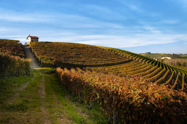
Barolo, Italy - October 2018: Autumn walk after harvest in the hiking paths between the rows and vineyards of nebbiolo grape, in the Barolo Langhe hills, most important wine district of Piedmont and Italy

Black summer truffles (Tuber Aestivum) and price tags on a trader stall of the Fiera del Tartufo (Truffle Fair) of Alba, Piedmont (Italy), most important international truffle market in the world

The Po and Monviso on a cold winter morning

a beautiful sunset with intense colors with the majesty of the Monviso in the background and in the foreground the valley of the Piedmontese Langhe, in Italy

White Truffles (Tuber Magnatum Pico) on a trader stall of the Fiera del Tartufo (Truffle Fair) of Alba, Piedmont (Italy), most important international truffle market in the world

In November 2016 the city of Garessio, in the province of Cuneo (Piedmont) was overwhelmed by an incredible flood caused by the exorbitant amount of rain that fell for three consecutive days. The water of the Tanaro river that crosses the city came out of the banks, flooding houses, shops, streets and agricultural fields. This image, created for a photographic reportage during the event, documents the men of the Civil Protection and the volunteers intent on shoveling the rubble created by the river water.

Cossano Belbo (Piedmont, Cuneo, Italy)

Langhe vineyards, Castiglione Falletto village and a tree as a frame at sunset. Unesco Site, Piedmont, Northern Italy Europe.

Chianale (Cuneo, Val Varaita, Piedmont, Italy), old typical mountain village in the Italian Alps at summer

Map of Piedmont with provinces isolated on white background. Vector Illustration - easy to edit, manipulate, resize or colorize.

Sunset and clouds on Mount Monviso seen from Mondovì, Cuneo.
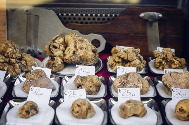
White Truffles (Tuber Magnatum Pico) on a trader stall of the Fiera del Tartufo (Truffle Fair) of Alba, Piedmont (Italy), most important international truffle market in the world
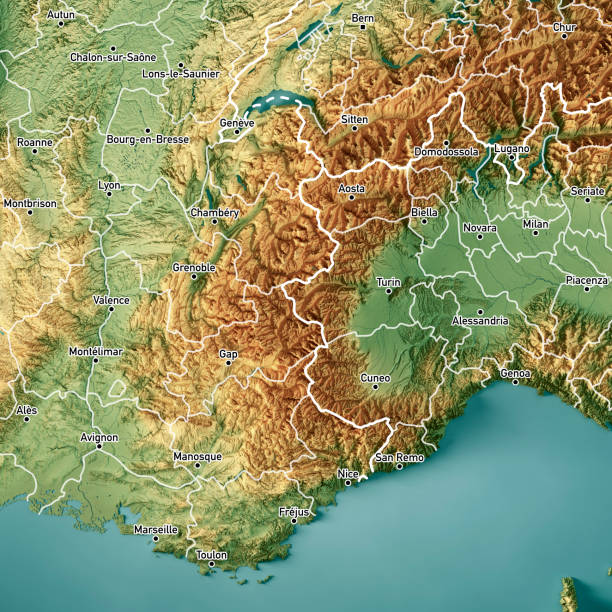
3D Render of a Topographic Map of the Frech and Italian Alps region. Version with administrative boundaries and city names. All source data is in the public domain. Color texture: Made with Natural Earth. http://www.naturalearthdata.com/downloads/10m-raster-data/10m-cross-blend-hypso/ Relief texture and Rivers: NASADEM data courtesy of NASA JPL (2020). https://doi.org/10.5067/MEaSUREs/NASADEM/NASADEM_HGT.001 Water texture: SRTM Water Body SWDB: https://dds.cr.usgs.gov/srtm/version2_1/SWBD/ Boundaries Level 0: Humanitarian Information Unit HIU, U.S. Department of State (database: LSIB) http://geonode.state.gov/layers/geonode%3ALSIB7a_Gen Boundaries Level 1: Made with Natural Earth. https://www.naturalearthdata.com/downloads/10m-cultural-vectors/

view of the sunny Elva valley. in the background the chief town (Serre), dominated by Chersogno on the left, Rocca la Marchisa in the center and Pelvo d'Elva on the right

Piedmont map, division by provinces and municipalities. Closed and perfectly editable polygons, polygon fill and color paths editable at will. Levels. Political geographic map. Italy

The charming village of Chianale in the heart of the Alps, with a picturesque river passing under stone bridge. Chianale, Italy, June 2021

Architecture of the Medieval Piedmont City of Cuneo in Italy. Vintage Italian lamps and balconies in Mediterranean style

Pollenzo, Italy - June 12, 2020: Exterior view of the castle of Pollenzo, italy, on june 12 2020; also known for its university of gastronomic sciences

rare and very expensive white truffles for sale in the very refined and exclusive gastronomy shop

Barolo, Cuneo, Italy - November 05, 2021: Barolo Village with Castle among the autumn colored vineyards on the Langhe hills

Barbaresco village and Langhe vineyards, Unesco Site, Piedmont, Northern Italy Europe.
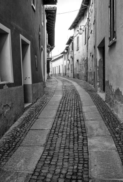
Old street in the village of Neive, in the hilly region of the Langhe (Piedmont, Northern Italy) UNESCO site since 2014; this area is world famous for its valuable red wines, like Barolo and Barbaresco.

Grinzane Cavour, Italy - October 24, 2018: Sunset in autumn, during harvest time, at the castle of Grinzane Cavour, surrounded by the vineyards of Langhe, the most importan wine district of Italy and Unesco Heritage for its landscape

Barbaresco village and Langhe vineyards, Unesco Site, Piedmont, Northern Italy Europe.
© 2025 iStockphoto LP. The iStock design is a trademark of iStockphoto LP. Browse millions of high-quality stock photos, illustrations, and videos.
Do Not Sell or Share