Turbulent ocean waves crashing on sandy beach, off the California Coast, after a pacific coast storm passed through the area. Taken at Davenport Landing, California, USA
Browse 370+ davenport california stock photos and images available, or search for santa cruz california or pacifica california to find more great stock photos and pictures.

Turbulent ocean waves crashing on sandy beach, off the California Coast, after a pacific coast storm passed through the area. Taken at Davenport Landing, California, USA

Davenport, California - United States - May 19, 2014: Consisting of two cells, the Davenport jail was constructed in 1914. Interestingly, it was used only two times from 1914 to 1936 when it was decommissioned. Today it houses a museum staffed by volunteers of the Santa Cruz Museum of Art and History.

Davenport, California - United States - May 19, 2014: A whaling captain, John Pope Davenport, settled nearby at Jarro Point in 1867. Today Davenport is noted for magnificent cliffs and bluffs overlooking the Pacific. Of historical interest is St. Vincent DePaul Church, the subject of a famous photograph by Ansel Adams.

Surf breaks on the rocks in Shark-Tooth Cove near Santa Cruz, California.

At Shark Fin Cove in Santa Cruz, California.

Photographing the various spots along the California Coast from San Francisco to Big Sur.

June 6, 2019 Davenport / CA / USA - People kite and wind surfing in the Pacific Ocean, near Santa Cruz, on a sunny and warm day

The historic Santa Cruz Railroad runs along the coast in the town of Davenport, CA.

A vintage-style map of Iowa with freeways, highways and major cities. Shoreline, lakes and rivers are very detailed. Includes an EPS and JPG of the map without roads and cities.

Yellow Bank Creek draining through the man-made tunnel (drilled in 1907-1908) in the Santa Cruz Mudstone.

Abandoned Pier Beach, Davenport, Santa Cruz County, California, USA.

Ocean waves crashing on secluded sandy beach, off the California coast. Taken in Davenport, California, USA.

Field of large orange colored pumpkins hidden in rural pumpkin patch. Taken in Davenport, California, USA.

Agricultural farmland under the blue summer sky in California

The Pacific Ocean washes against the beautiful and rugged coastline not far from Santa Cruz, California. This area, south of San Francisco, is known for its great surfing and gorgeous beaches.

Pumpkin farm with bright pumpkins around an old truck

Pelicans Fly Over California Coast

Davenport, Santa Cruz County, California, USA.

Abandoned Pier Beach, Davenport, Santa Cruz County, California

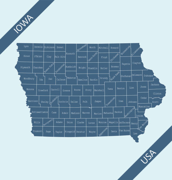
Highly detailed map of Iowa counties state of United States of America for web banner, mobile, smartphone, iPhone, iPad applications and educational use. The map is accurately prepared by a map expert.

Drainage of Yellow Bank Creek through the man-made tunnel (drilled in 1907-1908) in the Santa Cruz Mudstone. Davenport, Santa Cruz County, California.

Highly detailed map of iowa counties state of United States of America for book cover, brochure and web banner designs, iPhone, iPad, tablet, smart phone, mobile app and educational use.

Taken at Pigeon Point on the northern California coast. Located north of Santa Cruz, California.

Shark Fin Cove covered by breaking wave

Field of different size orange colored pumpkins scattered around in a rural pumpkin patch. Taken in Davenport, California, USA.

Egret resting on Santa Cruz California Beach at sunset with orange sky in background and crashing waves

Santa Cruz California Beach Bluffs at sunset, Aerial Drone view overlooking pacific ocean

Dramatic Sunset over Davenport Abandoned Pier. Davenport, Santa Cruz County, California, USA.

Ocean waves crashing on sandy beach and rocky cliffs off the California coast. Taken in Davenport, California, USA.

Drainage of Liddell Creek through the man-made tunnel (drilled in 1907-1908) in the Santa Cruz Mudstone.

Santa Cruz California Beach Bluffs at sunset, Aerial Drone view overlooking pacific ocean

Serene night on the California coast as the Milkyway galaxy rises over the Sharkfin Cove formation. Coastal fog approaches in the distance.

Santa Cruz California Beach Bluffs at sunset, Aerial Drone view overlooking pacific ocean

Handicapped ramp leading down to oceanside beach, where turbulent ocean waves are crashing on sandy beach, off the California Coast, after a pacific coast storm passed through the area. Taken at Davenport Landing, California, USA

Night sky stars and milky way at Shark Fin Cove, Davenport, California, USA

Turbulent ocean waves crashing on sandy beach, off the California Coast, after a pacific coast storm passed through the area. Taken at Davenport Landing, California, USA

Turbulent ocean waves crashing on sandy beach, off the California Coast, after a pacific coast storm passed through the area. Taken at Davenport Landing, California, USA

Turbulent ocean waves crashing on sandy beach, off the California Coast, after a pacific coast storm passed through the area. Taken at Davenport Landing, California, USA

Turbulent ocean waves crashing on sandy beach, off the California Coast, after a pacific coast storm passed through the area. Taken at Davenport Landing, California, USA

Turbulent ocean waves crashing on sandy beach, off the California Coast, after a pacific coast storm passed through the area. Taken at Davenport Landing, California, USA

Field of large orange colored pumpkins hidden in rural pumpkin patch. Taken in Davenport, California, USA.

Turbulent ocean waves crashing on sandy beach, off the California Coast, after a pacific coast storm passed through the area. Taken at Davenport Landing, California, USA

Turbulent ocean waves crashing on sandy beach, off the California Coast, after a pacific coast storm passed through the area. Taken at Davenport Landing, California, USA

One unrecognizable person standing on the shore of the Pacifica Ocean overlooking the surf and distant coastal mountins.
© 2025 iStockphoto LP. The iStock design is a trademark of iStockphoto LP. Browse millions of high-quality stock photos, illustrations, and videos.
Do Not Sell or Share