
Detroit MI City Vector Road Map Blue Text. All source data is in the public domain. U.S. Census Bureau Census Tiger. Used Layers: areawater, linearwater, roads. Statistics Canada. Used Layers: Road Network and Water.
Browse 40+ detroit street map stock photos and images available, or start a new search to explore more stock photos and images.
Detroit MI City Vector Road Map Blue Text. All source data is in the public domain. U.S. Census Bureau Census Tiger. Used Layers: areawater, linearwater, roads. Statistics Canada. Used Layers: Road Network and Water.

Topographic / Road map of Detroit, MI, USA. Original map data is open data via © OpenStreetMap contributors. All maps are layered and easy to edit. Roads have editable stroke.

3D Render of a Topographic Map of Detroit, Michigan, USA. All source data is in the public domain. Contains modified Copernicus Sentinel data (May 2019) courtesy of ESA. URL of source image: https://scihub.copernicus.eu/dhus/#/home. Relief texture SRTM data courtesy of NASA. URL of source image: https://search.earthdata.nasa.gov/search/granules/collection-details?p=C1000000240-LPDAAC_ECS&q=srtm%201%20arc&ok=srtm%201%20arc

Detroit MI City Vector Road Map Blue Horizontal. All source data is in the public domain. U.S. Census Bureau Census Tiger. Used Layers: areawater, linearwater, roads. Statistics Canada. Used Layers: Road Network and Water.
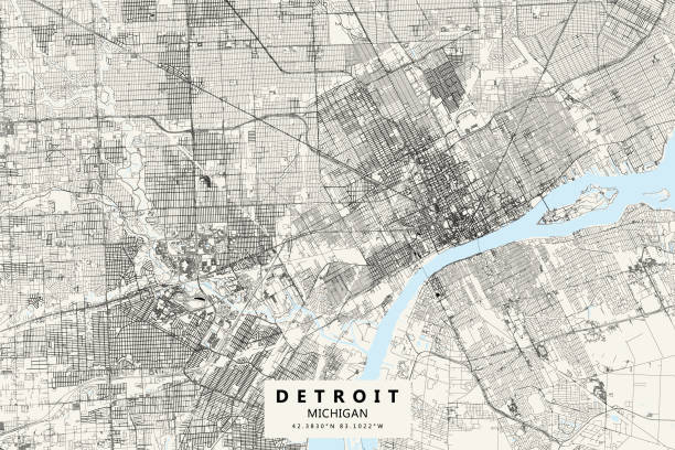
Poster Style Topographic / Road map of Detroit, MI, USA. All maps are layered and easy to edit. Roads have editable stroke.

Map Photography: Detroit City on a Road Map

Vector Illustration of a City Street Map of Detroit, Michigan, USA. Scale 1:60,000. All source data is in the public domain. U.S. Geological Survey, US Topo Used Layers: USGS The National Map: National Hydrography Dataset (NHD) USGS The National Map: National Transportation Dataset (NTD)

Poster Style Topographic / Road map of Detroit, MI, USA. All maps are layered and easy to edit. Roads have editable stroke.

Topographic / Road map of Detroit, MI, USA. Original map data is open data via © OpenStreetMap contributors. All maps are layered and easy to edit. Roads have editable stroke.

Michigan US State Vector Road Map Grey. All source data is in the public domain. Roads, Water, Regions, Urban Areas: Made with Natural Earth. https://www.naturalearthdata.com/downloads/10m-physical-vectors/ https://www.naturalearthdata.com/downloads/10m-cultural-vectors/

3D Render of a Topographic Map of Warren, Michigan, USA. All source data is in the public domain. Contains modified Copernicus Sentinel data (May 2019) courtesy of ESA. URL of source image: https://scihub.copernicus.eu/dhus/#/home. Relief texture SRTM data courtesy of NASA. URL of source image: https://search.earthdata.nasa.gov/search/granules/collection-details?p=C1000000240-LPDAAC_ECS&q=srtm%201%20arc&ok=srtm%201%20arc

Windsor ON City Vector Road Map Blue Text. All source data is in the public domain. Statistics Canada. Used Layers: Road Network and Water.
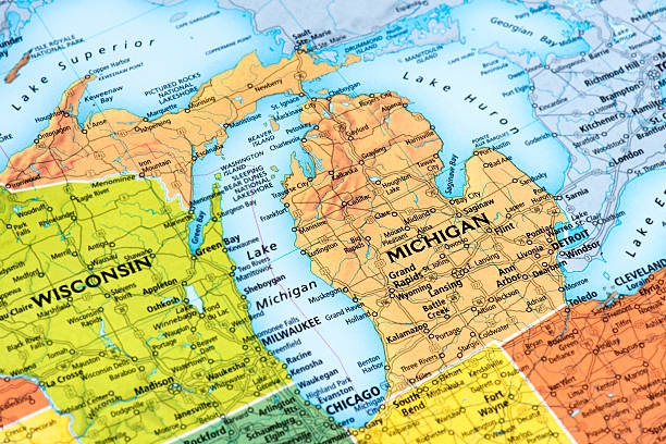
Map of Michigan State. Selective focus.

"Lansing, MI map. Source: ""World reference atlas"""

Topographic / Road map of Detroit, MI, USA. Original map data is open data via © OpenStreetMap contributors. All maps are layered and easy to edit. Roads have editable stroke.

A map downtown Detroit, Michigan. Includes highways, freeways, streets, parks, and points of interest, all on separate layers. Includes an extra-large JPG and a CS3 doc.

Detroit, MI map. Source: "World reference atlas"

Poster Style Topographic / Road map of Detroit, MI, USA. All maps are layered and easy to edit. Roads have editable stroke.

Topographic / Road map of Detroit, MI, USA. Original map data is open data via © OpenStreetMap contributors. All maps are layered and easy to edit. Roads have editable stroke.

Dearborn MI City Vector Road Map Blue Horizontal. All source data is in the public domain. U.S. Census Bureau Census Tiger. Used Layers: areawater, linearwater, roads.
![Detroit, MI map Detroit, MI map. Source: "World reference atlas"
[url=/search/lightbox/5890567][IMG]http://farm4.static.flickr.com/3574/3366761342_e502f57f15.jpg?v=0[/IMG][/url] detroit street map stock pictures, royalty-free photos & images](https://media.istockphoto.com/id/110927682/photo/detroit-mi-map.jpg?s=612x612&w=0&k=20&c=obHNKYYIgym7WL2H3TgWfyJ_uC70xsip71OWnDntR74=)
Detroit, MI map. Source: "World reference atlas" [url=/search/lightbox/5890567][IMG]http://farm4.static.flickr.com/3574/3366761342_e502f57f15.jpg?v=0[/IMG][/url]

Taylor MI City Vector Road Map Blue Horizontal. All source data is in the public domain. U.S. Census Bureau Census Tiger. Used Layers: areawater, linearwater, roads.

Taylor MI City Vector Road Map Blue Text. All source data is in the public domain. U.S. Census Bureau Census Tiger. Used Layers: areawater, linearwater, roads.

Vector Illustration of a City Street Map of Romulus and Detroit Airport, Michigan, USA. Scale 1:60,000. All source data is in the public domain. U.S. Geological Survey, US Topo Used Layers: USGS The National Map: National Hydrography Dataset (NHD) USGS The National Map: National Transportation Dataset (NTD)

Detroit on the map. Please check out my maps lightbox for more similar images. http://i70.photobucket.com/albums/i102/mzelkovi/maps-1.jpg
![Detroit, MI map Detroit, MI map. Source: "World reference atlas"[url=/search/lightbox/5890567][IMG]http://farm4.static.flickr.com/3574/3366761342_e502f57f15.jpg?v=0[/IMG][/url] detroit street map stock pictures, royalty-free photos & images](https://media.istockphoto.com/id/110926036/photo/detroit-mi-map.jpg?s=612x612&w=0&k=20&c=Fif-Q00u9CgfE-lHhiWpAd6qQX1ceRMarTM1OYSBTJI=)
Detroit, MI map. Source: "World reference atlas"[url=/search/lightbox/5890567][IMG]http://farm4.static.flickr.com/3574/3366761342_e502f57f15.jpg?v=0[/IMG][/url]

United States Of America Vector Road Map Grey. All source data is in the public domain. Roads, Water, Regions, Urban Areas: Made with Natural Earth. https://www.naturalearthdata.com/downloads/10m-physical-vectors/ https://www.naturalearthdata.com/downloads/10m-cultural-vectors/

Vector Illustration of a City Street Map of Livonia, Michigan, USA. Scale 1:60,000. All source data is in the public domain. U.S. Geological Survey, US Topo Used Layers: USGS The National Map: National Hydrography Dataset (NHD) USGS The National Map: National Transportation Dataset (NTD)

Detroit, MI map. Source: "World reference atlas"


