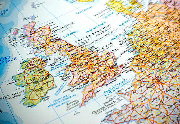
English Channel political map. Also British Channel. Arm of Atlantic Ocean separates Southern England from northern France and link to North Sea by Strait of Dover. Busiest shipping area in the world.
Browse 29,000+ english channel stock photos and images available, or search for english channel map or english channel tunnel to find more great stock photos and pictures.
English Channel political map. Also British Channel. Arm of Atlantic Ocean separates Southern England from northern France and link to North Sea by Strait of Dover. Busiest shipping area in the world.
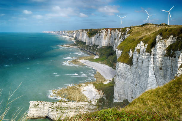
HDR view of the Alabaster cliffs near Fecamp, Normandy, France.

Yellow British fishing boat trawler alone in the English channel islands waters after leaving EU with no French fisherman boats or nets in view. Territorial waters under England's control.

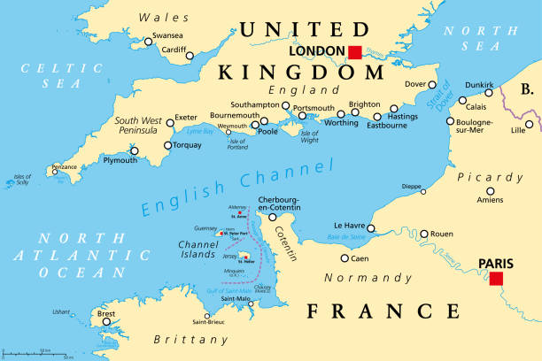
Northern France, political map. Coastline of France and United Kingdom along the English Channel, and along Bay of Biscay, with the Channel Islands. Coasts of Hauts-de-France, Normandy and Brittany.

Northern France, gray political map. Coastline of France and United Kingdom along the English Channel, and along Bay of Biscay, with Channel Islands. Coasts of Hauts-de-France, Normandy and Brittany.
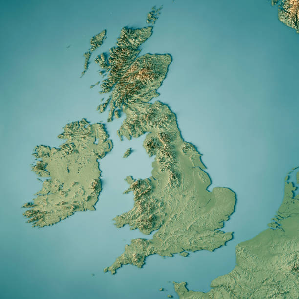
3D Render of a Topographic Map of the United Kingdom.All source data is in the public domain.Color texture: Made with Natural Earth. http://www.naturalearthdata.com/downloads/10m-raster-data/10m-cross-blend-hypso/Relief texture and Rivers: SRTM data courtesy of USGS. URL of source image: https://e4ftl01.cr.usgs.gov//MODV6_Dal_D/SRTM/SRTMGL1.003/2000.02.11/Water texture: SRTM Water Body SWDB:https://dds.cr.usgs.gov/srtm/version2_1/SWBD/
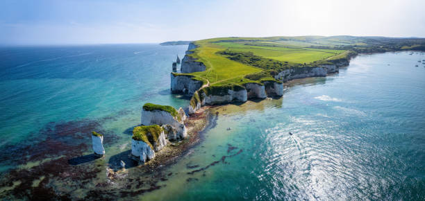
Panoramic aerial landscape view of the Old Harry Rocks headland, Dorset, England, during a sunny spring day

The White Cliffs of Dover in 1991 on old film stock.
Map of United Kingdom. Detail from the Europe Map.

Storm 'Eunice' hits the South Coast of Britain with strong winds and huge waves
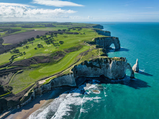
Étretat Coast Normandy, aerial view towards the beach and famous Chalk Cliffs of Etretat - Falaises d’Étretat with Failaise d’Aval and the L'Aiguille (the Needle) and Porte d'Aval Natural Arch at the Normandy Alabaster Coast under sunny sky. Drone Point of View. Porte d'Aval , Étretat, Seine-Maritime, Le Havre, Normandy, France, Europe

aerial view of Dover and dover harbour
Photograph taken from Dover of the busy strait between the ports of Dover (England) and Calais (France)
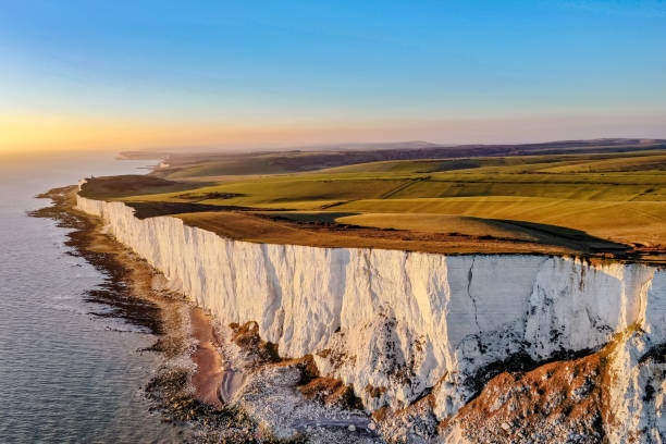
Aerial view of Beachy Head White Cliffs sunset English Channel East Sussex England Europe

Spectacular natural wonders of White Cliffs England

Nice aerial view of a giant container ship sailing at dawn in the English Channel

3D Render of a Topographic Map of the English Channel area, Calais-Dover. All source data is in the public domain. Contains modified Copernicus Sentinel data (May 2019) courtesy of ESA. URL of source image: https://scihub.copernicus.eu/dhus/#/home. Relief texture SRTM data courtesy of NASA. URL of source image: https://search.earthdata.nasa.gov/search/granules/collection-details?p=C1000000240-LPDAAC_ECS&q=srtm%201%20arc&ok=srtm%201%20arc

Ramsgate, United States – August 12, 2021: 26 migrants crossed the English Channel in a rubber dinghy landing in Ramsgate near the Ramsgate Tunnels. Main sands and the harbour in the background

A view of the English Channel from the cliffs of Beachy Head on a bright sunny day with a horizon, some clouds and a multi coloured sea.
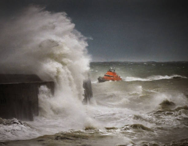
RNLI Lifeboat returns to harbor in a raging storm off the Sussex coast , UK

"A container ship going past the famous White Cliffs of Dover in the evening light. Kent, England"
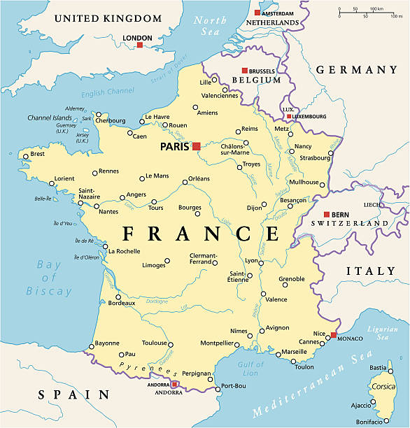
France Political Map with capital Paris, national borders, most important cities and rivers. English labeling and scaling. Illustration.
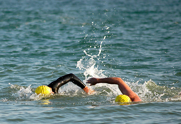
ocean swimming triathlon pair duel english channel duathlon biathlon wetsuit neoprene swim cap goggles waves ripples blue aqua

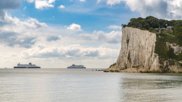
White Cliffs of Dover in Kent, England, looking out across the English Channel as 2 passenger ferries pass each other.

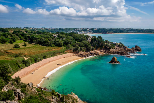
Northern France, touristic names of beaches and coastlines, political map. Coastline of France and United Kingdom along the English Channel, and along a part of Bay of Biscay, with Channel Islands.

ferries entering and leaving the port of Calais in France

Map of United Kingdom. Detail from the Europe Map.

The Needles on the Isle of Wight, on old camera film from 1988.

Fantastic aerial view on Etretat town on Normandian coastline and beach in bay (people walking)and water of Manche (English channel). Popular place for walking and making selfie with famus Falaise d'Avalnin right corner in distance

drone view of the White Cliffs of Dover and the Dover Patrol Monument statue of the South Foreland
St Margaret's at Cliffe, Kent, England, UK - September 18, 2017: Two ferries crossing the British Channel on the way between France and Dover

Schematic map of the Eurotunnel (Channel Tunnel). Vector.

Mighty waves in the English channel overwhelm Newhaven harbour lighthouse, East Sussex. UK Colour image but look monochrome

Seascape near Biville on the coast of English Channel in Normady. Manche, Cotentin, Cap de la Hague, France
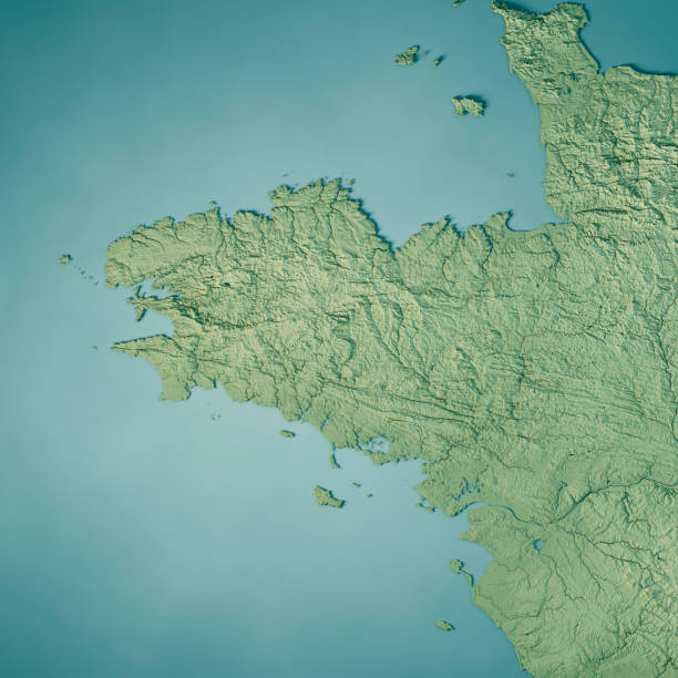
3D Render of a Topographic Map of the region Brittany in France. All source data is in the public domain. Color texture: Made with Natural Earth. http://www.naturalearthdata.com/downloads/10m-raster-data/10m-cross-blend-hypso/ Relief texture: NASADEM data courtesy of NASA JPL (2020). URL of source image: https://doi.org/10.5067/MEaSUREs/NASADEM/NASADEM_HGT.001 Water texture: SRTM Water Body SWDB: https://dds.cr.usgs.gov/srtm/version2_1/SWBD/ Boundaries Level 0: Humanitarian Information Unit HIU, U.S. Department of State (database: LSIB) http://geonode.state.gov/layers/geonode%3ALSIB7a_Gen

View of chalk cliffs, the lighthouse and the English Channel coastline

3D rendering and image composing: Topographic Map of UK. Including national borders, rivers and accurate longitude/latitude lines. High resolution available! High quality relief structure!

Highly detailed editable United Kingdom political map. Organized vector illustration on seprated layers.

english coastline with chalk cliffs seen from a boat from Poole to cherbourg

The White Cliffs of Dover, a landmark on the southeastern coast of England, striking for their composition of chalk.
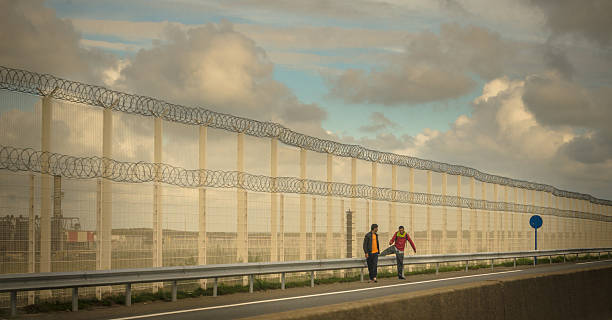
Calais, France - September 1, 2015: Migrants crisis - Illegal migrants, by the proximity of Calais port, try to find their way to ferries going to United Kingdom evading police security controls.
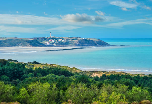
Beautiful landscape of the coast between Calais and Boulogn-sur-Mer

A storm whips up the sea creating rough waves and lots of spray

Drone photo of man and woman tourists walking at the Normandy seacoast at the yellow sand Bech in Etretat, Northern France

English Channel, gray political map. British Channel, arm of Atlantic Ocean, separates Southern England from northern France, link to North Sea by Strait of Dover. Busiest shipping area in the world.
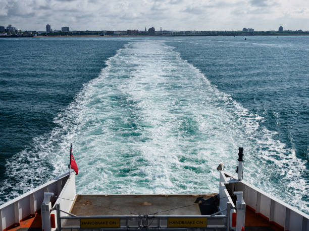
Looking back towards Portsmouth Harbour from the Isle of Wight ferry.

The chalk cliffs of Le Treport in Seine-Maritime on the English Channel

Rough seas with crashing waves in English Channel off Seaford in East Sussex.

Granville, Manche / France - 18 August, 2019: view of the casino on the boardwalk in Granville on the Normandy coast
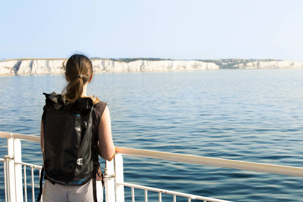
Backpacker crossing La Manche channel from Dover to Calais

Low tide and a lovely winter sunset at Steephill Cove in Ventnor on the Isle of Wight.