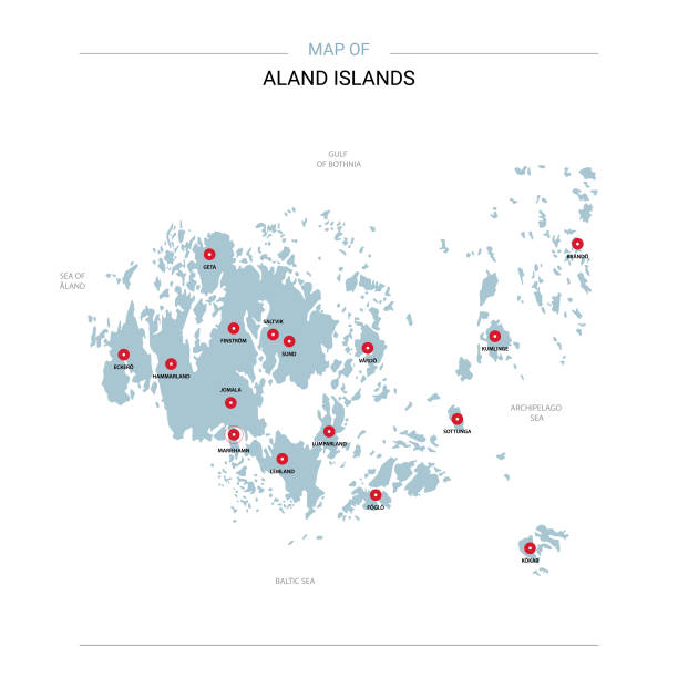
Aland Islands vector map. Editable template with regions, cities, red pins and blue surface on white background.
Browse 640+ europe map with finland in red stock photos and images available, or start a new search to explore more stock photos and images.
Aland Islands vector map. Editable template with regions, cities, red pins and blue surface on white background.

Illustration map of Lapland. Vector illustration
Highly detailed map of Europe for your design and products.

Silhouettes of Countries from Europe and America in black and red color isolated on white.
Hand painted water color graphic drawing on white. Cute and bright Xmas symbol.

http://farm8.staticflickr.com/7189/6818724910_54c206caf8.jpg
Map of Aland isolated on white background. Includes 9 buttons with a flat design style for your design, in different colors (red, orange, yellow, green, blue, purple, gray, black, white, line art), each icon is separated on its own layer. Vector Illustration (EPS10, well layered and grouped). Easy to edit, manipulate, resize or colorize. Please do not hesitate to contact me if you have any questions, or need to customise the illustration. http://www.istockphoto.com/portfolio/bgblue

Set of 6 Aland maps created in a Low Poly style, isolated on a blank background. Modern and trendy polygonal mosaic with beautiful color gradients (colors used: Blue, Green, Orange, Yellow, Red, Pink, Purple, Black, Gray). Vector Illustration (EPS10, well layered and grouped). Easy to edit, manipulate, resize or colorize.

3D map of Finland with 4 different colors for your design and products.

Finland character with forbidden symbol isolated on white background. 3d illustration

3d isometric Map of Finland with national flag. Vector Illustration.

Finland vector map. Editable template with regions, cities, red pins and blue surface on white background.

Europe Map - Vintage Detailed Vector Illustration

A 3d simplified european map with each country flag

Eurasia Europa Russia China India Indonesia Thailand Map - Detailed Vector Illustration

3D Render of a Map of Finland with Straight Pins at the Position of important Cities. Vintage Color Style. Very high resolution available!All source data is in the public domain.http://www.naturalearthdata.com/about/terms-of-use/Made with Natural Earth: Internal Administrative Boundaries, Populated Placeshttp://www.naturalearthdata.com/downloads/10m-cultural-vectors/

Map of Finnland with pin set on Helsinki.

Map of Finland on simple political globe with watery blue oceans. 3D illustration 3D model of planet created and rendered in Cheetah3D software, 9 Mar 2017. Country borders cut manualy into the 3D mesh based on current world map.

A 3d simplified european map with each country flag

Coronavirus pandemic reported on the map of Finland. Spread of COVID-19 represented with red circles on a black background, like a radar screen. Included: Big set of infographic elements. This large selection of modern elements includes charts, pie charts, diagrams, demographic graph, people graph, datas, time lines, flowcharts, icons... (Colors used: red, white, black). Vector Illustration (EPS10, well layered and grouped). Easy to edit, manipulate, resize or colorize.

A 3d simplified european map with each country boundary. The map is blue on a plain white background. The country border of Bulgaria is highlighted in red
Hand drawn vector illustration of a map of Europe.

A 3d simplified european map with each country flag

A 3d simplified european map with each country flag

Map of Finland - Vintage Vector illustration

A 3d simplified european map with each country flag

Finland highlighted in red on planet Earth with visible city lights. 3D illustration with detailed planet surface. 3D model of planet created and rendered in Cheetah3D software, 9 Mar 2017. Some layers of planet surface use textures furnished by NASA, Blue Marble collection: http://visibleearth.nasa.gov/view_cat.php?categoryID=1484
Map of Aland created with pink and purple square dots on a blank background. Modern and trendy mosaic illustration in pixel art style. Vector Illustration (EPS file, well layered and grouped). Easy to edit, manipulate, resize or colorize. Vector and Jpeg file of different sizes.

A 3d simplified european map with each country boundary. The map is blue on a plain white background. The country border of Sweden is highlighted in red

Map of Aland in a realistic neon sign style. The map is created with a pink glowing neon light on a dark brick wall. Modern and trendy illustration with beautiful bright colors. Vector Illustration (EPS10, well layered and grouped). Easy to edit, manipulate, resize or colorize.

Set of 6 Finland maps created in a Low Poly style, isolated on a blank background. Modern and trendy polygonal mosaic with beautiful color gradients (colors used: Blue, Green, Orange, Yellow, Red, Pink, Purple, Black, Gray). Vector Illustration (EPS10, well layered and grouped). Easy to edit, manipulate, resize or colorize.

A 3d simplified european map with each country boundary. The map is blue on a plain white background. The country border of Estonia is highlighted in red

Denmark Map - Zoom on World Map. Animated Vector Map of the Denmark. 4K Video Footage. Motion Graphics

Europe Map - Detailed Vector Illustration

Portrait of a men with the Europe map on his face.

Satellite view of Finland highlighted in red on planet Earth at night with borderlines and city lights. 3D illustration. Elements of this image furnished by NASA. 3D model of planet created and rendered in Cheetah3D software 25/09/2018. Some layers of planet surface use textures furnished by NASA, Blue Marble collection: http://visibleearth.nasa.gov/view_cat.php?categoryID=1484

Finland in red on model of planet Earth with clouds and atmosphere in space. 3D illustration. Elements of this image furnished by NASA. 3D model of planet created and rendered in Cheetah3D software 25/09/2018. Some layers of planet surface use textures furnished by NASA, Blue Marble collection: http://visibleearth.nasa.gov/view_cat.php?categoryID=1484

A 3d simplified european map with each country boundary. The map is blue on a plain white background. The country border of Finland is highlighted in red

A top shot of an isolated plate with tomatosoup and cream in the shape of Finland (Europe). (series)

Map of Norway - Vintage Vector illustration

3D render illustration of red creative abstract New Year 2019 holiday beginning celebration concept on cracked surface isolated on white background

Curved paper map of Finland with capital Helsinki on Gray Background. Four different Map pin set. Vector Illustration.

Arctic Region Map - Vintage Detailed Vector Illustration


