
Images
Browse 40+ kimberley map stock photos and images available, or start a new search to explore more stock photos and images.
![South Africa under loupe South Africa map. Source: "World reference atlas"
[url=/search/lightbox/5890567][IMG]http://farm4.static.flickr.com/3574/3366761342_e502f57f15.jpg?v=0[/IMG][/url] kimberley map stock pictures, royalty-free photos & images](https://media.istockphoto.com/id/112802481/photo/south-africa-under-loupe.jpg?s=612x612&w=0&k=20&c=QcXs1DZ29o2fGGlH3FXqFYC9P7U1Sx3jk62sk4ObJJk=)
South Africa map. Source: "World reference atlas" [url=/search/lightbox/5890567][IMG]http://farm4.static.flickr.com/3574/3366761342_e502f57f15.jpg?v=0[/IMG][/url]
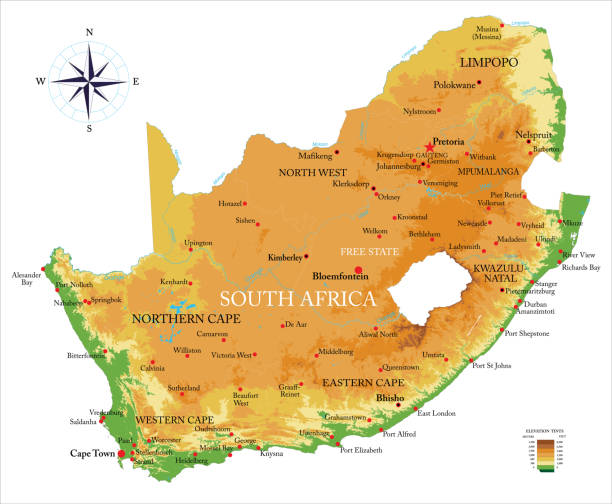
Highly detailed physical map of the South Africa, in vector format,with all the relief forms,regions and big cities.

![South Africa South Africa map. Source: "World reference atlas"
[url=/search/lightbox/5890567][IMG]http://farm4.static.flickr.com/3574/3366761342_e502f57f15.jpg?v=0[/IMG][/url] kimberley map stock pictures, royalty-free photos & images](https://media.istockphoto.com/id/110925055/photo/south-africa.jpg?s=612x612&w=0&k=20&c=-Ko356XP8VmHqzo-mHrkWf3MhNaotF-jIU3LNfoA9E8=)
South Africa map. Source: "World reference atlas" [url=/search/lightbox/5890567][IMG]http://farm4.static.flickr.com/3574/3366761342_e502f57f15.jpg?v=0[/IMG][/url]
Our creative library is free of AI-generated contentChoose your visuals with confidence knowing our creative library is free from AI-generated content, so your searches only return safe, high-quality visuals you can trust.

A close-up photograph of South Africa from a desktop globe. Adobe RGB color profile.

This file is a map highlighting South Africa as well as it's provinces and capital cities. This map also shows surrounding countries and capital cities if present. This map has text labels for the countries, provinces, capital cities and major bodies of water. ZOOM IN on this highly detailed map, it is a great addition to the collection. This file will work well for your print or web based project. This file is layered and grouped (labeled in ai v10 file), making it a very easy file to work with. This download contains an editable ai v10 and eps file, as well as a large JPG file.

Detailed map of South Africa.

3d verctor map of cities and roads in Africa. South Africa and its neighbors.

This vector map is accurately prepared by a GIS and remote sensing expert with highly detailed information.

South Africa higt detailed map with subdivisions. Administrative map of South Africa with districts and cities name, colored by states and administrative districts. Vector illustration with editable and labelled layers.


Political South Africa map with Main Cities.

Vintage engraving of a Plan of the Battle of Magersfontein, fought on 11 December 1899, at Magersfontein near Kimberley on the borders of the Cape Colony and the independent republic of the Orange Free State.

3D Render of a Topographic Map of the Indian Ocean with the clouds from April 16, 2025. Category 5 Severe Tropical Cyclone Errol west of Australia.All source data is in the public domain.Cloud texture: Global Imagery Browse Services (GIBS) courtesy of NASA, VIIRS data courtesy of NOAA.https://www.earthdata.nasa.gov/eosdis/science-system-description/eosdis-components/gibsColor texture: Made with Natural Earth.http://www.naturalearthdata.com/downloads/10m-raster-data/10m-cross-blend-hypso/Relief texture: GMTED 2010 data courtesy of USGS. URL of source image:https://topotools.cr.usgs.gov/gmted_viewer/viewer.htmWater texture: SRTM Water Body SWDB: https://dds.cr.usgs.gov/srtm/version2_1/SWBD/


Cyclone Errol 2025 Track Australia Infographic. Map projection: World Miller Cylindrical. All source data is in the public domain. NOAA's International Best Track Archive for Climate Stewardship (IBTrACS) data. Countries and Boundaries: Made with Natural Earth.

Cyclone Sean 2025 Track Australia Infographic. Map projection: World Miller Cylindrical. All source data is in the public domain. NOAA's International Best Track Archive for Climate Stewardship (IBTrACS) data. Countries and Boundaries: Made with Natural Earth.

Kimberley, South Africa .Source: "World reference atlas"

Kimberley, South Africa .Source: "World reference atlas"


Precipitation Weather Map of Cyclone Fina over the Timor Sea affecting Northern Territory, Australia on November 23, 2025 at 18:00 UTC. All source data is in the public domain. Made with data courtesy from Goddard Earth Sciences Data and Information Services Center (GES DISC), NOAA. NCEP/CPC L3 Half Hourly 4km Global Merged IR V1. Countries and Boundaries: Made with Natural Earth.

Northern Cape Province (Provinces of South Africa, Republic of South Africa, Administrative divisions, RSA) map vector illustration, scribble sketch Northern Cape map

3D Render of a Topographic Map of the Indian Ocean with the clouds from February 07, 2026. Category 2 tropical Cyclone Mitchell approaching Western Australia.All source data is in the public domain.Cloud texture: Global Imagery Browse Services (GIBS) courtesy of NASA, VIIRS data courtesy of NOAA.https://www.earthdata.nasa.gov/eosdis/science-system-description/eosdis-components/gibsColor texture: Made with Natural Earth.http://www.naturalearthdata.com/downloads/10m-raster-data/10m-cross-blend-hypso/Relief texture: GMTED 2010 data courtesy of USGS. URL of source image:https://topotools.cr.usgs.gov/gmted_viewer/viewer.htmWater texture: SRTM Water Body SWDB: https://dds.cr.usgs.gov/srtm/version2_1/SWBD/

3D Render of a Topographic Map of the Indian Ocean with the clouds from February 07, 2026. Category 2 tropical Cyclone Mitchell approaching Western Australia.All source data is in the public domain.Cloud texture: Global Imagery Browse Services (GIBS) courtesy of NASA, VIIRS data courtesy of NOAA.https://www.earthdata.nasa.gov/eosdis/science-system-description/eosdis-components/gibsColor texture: Made with Natural Earth.http://www.naturalearthdata.com/downloads/10m-raster-data/10m-cross-blend-hypso/Relief texture: GMTED 2010 data courtesy of USGS. URL of source image:https://topotools.cr.usgs.gov/gmted_viewer/viewer.htmWater texture: SRTM Water Body SWDB: https://dds.cr.usgs.gov/srtm/version2_1/SWBD/


Map and Flag of South Africa. Source: "World reference atlas"

Precipitation Weather Map of Cyclone Zelia over the Indian Ocean near Western Australia on February 13, 2025. All source data is in the public domain. Made with data courtesy from Goddard Earth Sciences Data and Information Services Center (GES DISC), NOAA. NCEP/CPC L3 Half Hourly 4km Global Merged IR V1. Countries and Boundaries: Made with Natural Earth.

Precipitation Weather Map of Cyclone Mitchell approaching West Australia on February 07, 2026 at 06:00 UTC. All source data is in the public domain. Made with data courtesy from Goddard Earth Sciences Data and Information Services Center (GES DISC), NOAA. NCEP/CPC L3 Half Hourly 4km Global Merged IR V1. Countries and Boundaries: Made with Natural Earth.

Printable outline vector map of South Africa for educational purposes. The map is accurately prepared by a map expert.


Northern Cape Province (Provinces of South Africa, Republic of South Africa, Administrative divisions, RSA) map vector illustration, scribble sketch Northern Cape map

Northern Cape Province (Provinces of South Africa, Republic of South Africa, Administrative divisions, RSA) map vector illustration, scribble sketch Northern Cape map

This vector map is accurately prepared by a GIS and remote sensing expert with highly detailed information.
![Map and Flag of South Africa Map and Flag of South Africa. Source: "World reference atlas"
[url=/search/lightbox/5890567][IMG]http://farm4.static.flickr.com/3574/3366761342_e502f57f15.jpg?v=0[/IMG][/url] kimberley map stock pictures, royalty-free photos & images](https://media.istockphoto.com/id/122294811/photo/map-and-flag-of-south-africa.jpg?s=612x612&w=0&k=20&c=_CykuQ6alpyty3Phu9VHyXq8vIwCSqGkZWs37x_Gyp8=)
Map and Flag of South Africa. Source: "World reference atlas" [url=/search/lightbox/5890567][IMG]http://farm4.static.flickr.com/3574/3366761342_e502f57f15.jpg?v=0[/IMG][/url]

Downloadable outline vector map of South Africa for educational purposes. The map is accurately prepared by a map expert.
of1