Images
407 Images and Stock Photos
View massachusetts-cities-and-towns-map videos
Browse 400+ massachusetts-cities-and-towns-map stock photos and images available, or start a new search to explore more stock photos and images.
Most popular

Boston USA City Map in Retro Style. Outline Map. Vector Illustration.

Map centered on the city of Boston. Shallow depth of field
Our creative library is free of AI-generated contentChoose your visuals with confidence knowing our creative library is free from AI-generated content, so your searches only return safe, high-quality visuals you can trust.

freehand drawing Sites New York City

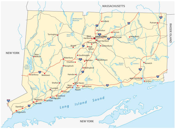
Connecticut administrative, political vector map

Vector Illustration of a City Street Map of Cambridge, Massachusetts, USA. Scale 1:60,000. All source data is in the public domain. U.S. Geological Survey, US Topo Used Layers: USGS The National Map: National Hydrography Dataset (NHD) USGS The National Map: National Transportation Dataset (NTD)

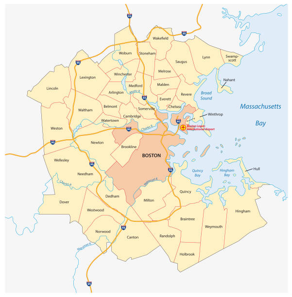
Vector Illustration of a City Street Map of Boston, Massachusetts, USA. Scale 1:60,000. All source data is in the public domain. U.S. Geological Survey, US Topo Used Layers: USGS The National Map: National Hydrography Dataset (NHD) USGS The National Map: National Transportation Dataset (NTD)

Boston USA City Map in Retro Style. Outline Map. Vector Illustration.

Flat Modern City Street Map Downtown Boston and Surroundings in Black and White

A red pushpin pointing to Boston, Massachusetts on a map.

Boston Massachusetts, United States - August 6, 2021: View of passengers waiting for the green line train approaching the Museum of Fine Arts station, in Boston.


Boston Massachusetts, United States - August 8, 2021: View of passengers waiting for the train at the subway station, in Boston. The subway system has three heavy rail rapid transit lines and two light rail lines.

MA Barnstable Provincetown Vector Road Map. All source data is in the public domain. U.S. Census Bureau Census Tiger. Used Layers: areawater, linearwater, roads, rails, cousub, pointlm, uac10.


MA Hampshire Northampton Vector Road Map. All source data is in the public domain. U.S. Census Bureau Census Tiger. Used Layers: areawater, linearwater, roads, rails, cousub, pointlm, uac10.


MA Barnstable Bourne Vector Road Map. All source data is in the public domain. U.S. Census Bureau Census Tiger. Used Layers: areawater, linearwater, roads, rails, cousub, pointlm, uac10.

Vector Illustration of a City Street Map of Attleboro, Massachusetts, USA. Scale 1:60,000. All source data is in the public domain. U.S. Geological Survey, US Topo Used Layers: USGS The National Map: National Hydrography Dataset (NHD) USGS The National Map: National Transportation Dataset (NTD)

simplified map of the city of Boston aerial view. 3d rendering

Romania background with traditional symbols of country architecture food map costumes

MA Berkshire Lenox Vector Road Map. All source data is in the public domain. U.S. Census Bureau Census Tiger. Used Layers: areawater, linearwater, roads, rails, cousub, pointlm, uac10.

MA Middlesex Woburn Vector Road Map. All source data is in the public domain. U.S. Census Bureau Census Tiger. Used Layers: areawater, linearwater, roads, rails, cousub, pointlm, uac10.

MA Barnstable Yarmouth Vector Road Map. All source data is in the public domain. U.S. Census Bureau Census Tiger. Used Layers: areawater, linearwater, roads, rails, cousub, pointlm, uac10.

MA Hampden Holyoke Vector Road Map. All source data is in the public domain. U.S. Census Bureau Census Tiger. Used Layers: areawater, linearwater, roads, rails, cousub, pointlm, uac10.

MA Essex Beverly Vector Road Map. All source data is in the public domain. U.S. Census Bureau Census Tiger. Used Layers: areawater, linearwater, roads, rails, cousub, pointlm, uac10.


Boston Massachusetts, United States - July 27, 2025: View of passengers waiting for the train at the subway station, in Boston. The subway system has three heavy rail rapid transit lines and two light rail lines.

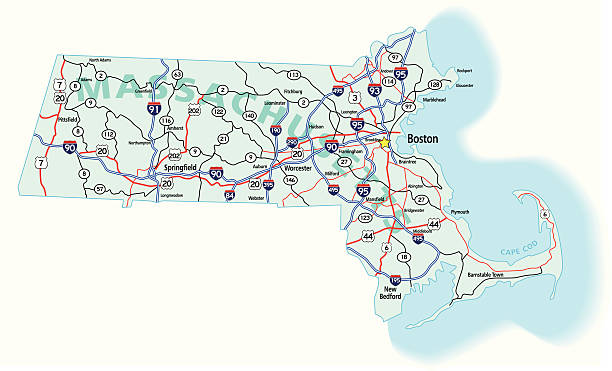
Vector Illustration of a Road Map of Massachusetts State, USA. All source data is in the public domain. U.S. Geological Survey, US Topo Used Layers: USGS The National Map: National Hydrography Dataset (NHD) USGS The National Map: National Transportation Dataset (NTD)


Poster city skyline Boston, Flat style vector illustration

Vector Illustration of a City Street Map of Somerville, Massachusetts, USA. Scale 1:60,000. All source data is in the public domain. U.S. Geological Survey, US Topo Used Layers: USGS The National Map: National Hydrography Dataset (NHD) USGS The National Map: National Transportation Dataset (NTD)

MA Essex Gloucester Vector Road Map. All source data is in the public domain. U.S. Census Bureau Census Tiger. Used Layers: areawater, linearwater, roads, rails, cousub, pointlm, uac10.

rhode island administrative and political vector map

freehand drawing Sites New York City

MA Essex Salem Vector Road Map. All source data is in the public domain. U.S. Census Bureau Census Tiger. Used Layers: areawater, linearwater, roads, rails, cousub, pointlm, uac10.

Massachusetts US State Vector Road Map Grey. All source data is in the public domain. U.S. Census Bureau Census Tiger. Used Layers: areawater, linearwater, urban areas, roads.

Vector Illustration of a City Street Map of Pittsfield, Massachusetts, USA. Scale 1:60,000. All source data is in the public domain. U.S. Geological Survey, US Topo Used Layers: USGS The National Map: National Hydrography Dataset (NHD) USGS The National Map: National Transportation Dataset (NTD)

MA Bristol Fall River Vector Road Map. All source data is in the public domain. U.S. Census Bureau Census Tiger. Used Layers: areawater, linearwater, roads, rails, cousub, pointlm, uac10.

19th century black and white photograph of Harvard University buildings and surroundings: Map


MA Barnstable Falmouth Vector Road Map. All source data is in the public domain. U.S. Census Bureau Census Tiger. Used Layers: areawater, linearwater, roads, rails, cousub, pointlm, uac10.


Vector Illustration of a City Street Map of Fall River, Massachusetts, USA. Scale 1:60,000. All source data is in the public domain. U.S. Geological Survey, US Topo Used Layers: USGS The National Map: National Hydrography Dataset (NHD) USGS The National Map: National Transportation Dataset (NTD)

MA Essex Danvers Vector Road Map. All source data is in the public domain. U.S. Census Bureau Census Tiger. Used Layers: areawater, linearwater, roads, rails, cousub, pointlm, uac10.

Vector Illustration of a City Street Map of New Bedford, Massachusetts, USA. Scale 1:60,000. All source data is in the public domain. U.S. Geological Survey, US Topo Used Layers: USGS The National Map: National Hydrography Dataset (NHD) USGS The National Map: National Transportation Dataset (NTD)

MA Bristol Dartmouth Vector Road Map. All source data is in the public domain. U.S. Census Bureau Census Tiger. Used Layers: areawater, linearwater, roads, rails, cousub, pointlm, uac10.


MA Bristol Attleboro Vector Road Map. All source data is in the public domain. U.S. Census Bureau Census Tiger. Used Layers: areawater, linearwater, roads, rails, cousub, pointlm, uac10.

MA Barnstable Wellfleet Vector Road Map. All source data is in the public domain. U.S. Census Bureau Census Tiger. Used Layers: areawater, linearwater, roads, rails, cousub, pointlm, uac10.

Satellite view of Boston, map of the city with house and building. Skyscrapers. Usa. 3d rendering.Cinema 4d it was the software, smart osm

MA Dukes Oak Bluffs Vector Road Map. All source data is in the public domain. U.S. Census Bureau Census Tiger. Used Layers: areawater, linearwater, roads, rails, cousub, pointlm, uac10.
of7Next