
Images
Browse 40+ nantucket aerial stock photos and images available, or search for nantucket island to find more great stock photos and pictures.

3D Render of a Topographic Map of Nantucket Island, Massachusetts. All source data is in the public domain. Color and Water texture: Contains modified Copernicus Sentinel data courtesy of ESA. URL of source image: https://dataspace.copernicus.eu/explore-data/data-collections/sentinel-data/sentinel-2 Relief texture: SRTM data courtesy of NASA JPL (2020). URL of source image: https://lpdaac.usgs.gov/products/srtmgl1v003/


This is a detailed vector map of the island of Nantucket, Massachusetts.

Views of the Head of the Harbor in Nantucket island, Massachusetts, from a charted flight
Our creative library is free of AI-generated contentChoose your visuals with confidence knowing our creative library is free from AI-generated content, so your searches only return safe, high-quality visuals you can trust.


View of Nantucket Island from the airplane with a clear blue sky

3D Render of a Topographic Map of the State of Massachusetts, USA. All source data is in the public domain. Color texture: Made with Natural Earth. http://www.naturalearthdata.com/downloads/10m-raster-data/10m-cross-blend-hypso/ Relief texture and Rivers: SRTM data courtesy of USGS. URL of source image: https://e4ftl01.cr.usgs.gov//MODV6_Dal_D/SRTM/SRTMGL1.003/2000.02.11/ Water texture: SRTM Water Body SWDB: https://dds.cr.usgs.gov/srtm/version2_1/SWBD/


3D Render of a Topographic Map of Cape Cod, Nantucket Sound, Nantucket Island and Martha's Vineyard. All source data is in the public domain. Color and Water texture: Contains modified Copernicus Sentinel data courtesy of ESA. URL of source image: https://dataspace.copernicus.eu/explore-data/data-collections/sentinel-data/sentinel-2 Relief texture: SRTM data courtesy of NASA JPL (2020). URL of source image: https://lpdaac.usgs.gov/products/srtmgl1v003/
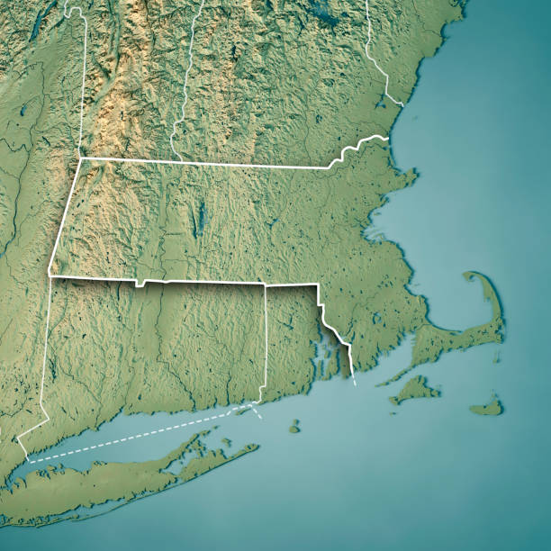
3D Render of a Topographic Map of the State of Massachusetts, USA. All source data is in the public domain. Color texture: Made with Natural Earth. http://www.naturalearthdata.com/downloads/10m-raster-data/10m-cross-blend-hypso/ Boundaries Level 1: USGS, National Map, National Boundary Data. https://viewer.nationalmap.gov/basic/#productSearch Relief texture and Rivers: SRTM data courtesy of USGS. URL of source image: https://e4ftl01.cr.usgs.gov//MODV6_Dal_D/SRTM/SRTMGL1.003/2000.02.11/ Water texture: SRTM Water Body SWDB: https://dds.cr.usgs.gov/srtm/version2_1/SWBD/

Aerial view of Brant Point Lighthouse on Nantucket Island with boats in the harbor and a clear blue sky.

3D Render of a Topographic Map of the State of Massachusetts, USA. All source data is in the public domain. Relief texture and Rivers: SRTM data courtesy of USGS. URL of source image: https://e4ftl01.cr.usgs.gov//MODV6_Dal_D/SRTM/SRTMGL1.003/2000.02.11/ Water texture: SRTM Water Body SWDB: https://dds.cr.usgs.gov/srtm/version2_1/SWBD/

3D Render of a Topographic Map of the State of Massachusetts, USA. All source data is in the public domain. Relief texture and Rivers: SRTM data courtesy of USGS. URL of source image: https://e4ftl01.cr.usgs.gov//MODV6_Dal_D/SRTM/SRTMGL1.003/2000.02.11/ Water texture: SRTM Water Body SWDB: https://dds.cr.usgs.gov/srtm/version2_1/SWBD/

3D Render of a Topographic Map of the State of Massachusetts, USA. All source data is in the public domain. Boundaries Level 1: USGS, National Map, National Boundary Data. https://viewer.nationalmap.gov/basic/#productSearch Relief texture and Rivers: SRTM data courtesy of USGS. URL of source image: https://e4ftl01.cr.usgs.gov//MODV6_Dal_D/SRTM/SRTMGL1.003/2000.02.11/ Water texture: SRTM Water Body SWDB: https://dds.cr.usgs.gov/srtm/version2_1/SWBD/


"The island of Nantucket, Massachusetts. View my other coastal New England photos:"


3D Render of a Topographic Map of the State of Massachusetts, USA. All source data is in the public domain. Boundaries Level 1: USGS, National Map, National Boundary Data. https://viewer.nationalmap.gov/basic/#productSearch Relief texture and Rivers: SRTM data courtesy of USGS. URL of source image: https://e4ftl01.cr.usgs.gov//MODV6_Dal_D/SRTM/SRTMGL1.003/2000.02.11/ Water texture: SRTM Water Body SWDB: https://dds.cr.usgs.gov/srtm/version2_1/SWBD/


