historic city scenery seen in Portland, Maine (USA)
Browse 470+ portland maine street stock photos and images available, or start a new search to explore more stock photos and images.
historic city scenery seen in Portland, Maine (USA)

Portland, Maine, USA downtown city skyline at dusk.

Portland, Maine, USA coastal townscape on Portland Harbor.

Portland is the largest city in the U.S. state of Maine and the seat of Cumberland County.

Portland is a port city and the most populous city in the U.S. state of Maine and the seat of Cumberland County.
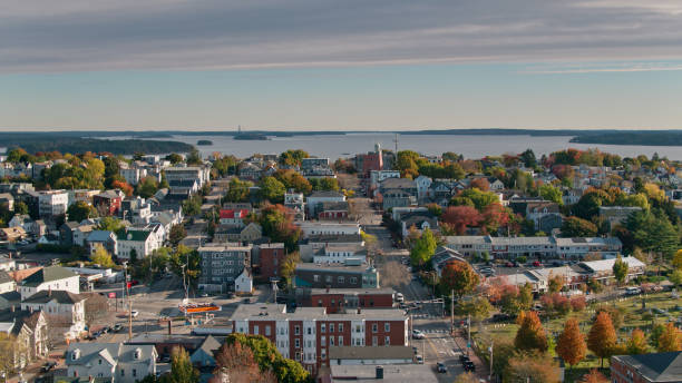
Aerial shot of residential streets in Portland, Maine, looking across rooftops in the East End towards the islands in Casco Bay. Authorization was obtained from the FAA for this operation in restricted airspace.

Portland, Maine, USA downtown cityscape.

Portland, ME, USA - October 8, 2015: Cobbled Street Lined with shops and Pubs in the Old Port District at night. Portland’s Old Port is one of the most successful revitalized warehouse districts in the country. Seamlessly connected to the waterfront, the Old Port is both a working waterfront and a local shopping, dining, residential, and entertainment district.

Portland, ME, USA - October 10, 2012: cobbled street lined with shops and pubs in the old port district. 19th-century brick buildings and gas street lights line the streets of this historic district of Portland.

Aerial shot of Downtown Portland, Maine on a sunny morning in Fall. Authorization was obtained from the FAA for this operation in restricted airspace.
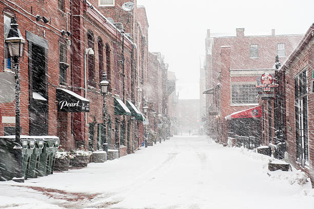
Portland, Maine, USA - January 16, 2016: Wharf Street in the historic Old Port section of Portland, Maine during a winter snow storm.

Portland, Maine, USA - People walking the street lined with shops and pubs in the Old Port district.

Portland, Maine, USA - Street in the downtown district.

traffic on road with cityscape and skyline of portland at twilight

Portland, Maine, USA downtown skyline.

Aerial view of residential area near Casco Bay in Portland.

Portland, Maine. February 17, 2018. The iconic Market street in the city of Portland Maine on an overcast day.

Residential city street block-Portland, Maine. Nobody. Horizontal

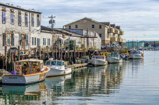
A pier filled with lobster traps and an old building, old port, in Portland, Maine. USA

Portland, Maine, USA - Homeless people gathering and camping in city park in downtown.

Casco Bay Bridge spans Fore River connecting South Portland and Portland in Maine.

Vector Illustration of a Road Map of Maine State, USA. All source data is in the public domain. U.S. Geological Survey, US Topo Used Layers: USGS The National Map: National Hydrography Dataset (NHD) USGS The National Map: National Transportation Dataset (NTD)

Aerial view of downtown Portland, Maine along Congress street

Portland, Maine, USA - People crossing the street in downtown district taffic.

Portland is a port city and the most populous city in the U.S. state of Maine and the seat of Cumberland County.

Dark alley in Old Port of Portland. Maine, USA

Aerial shot of Downtown Portland, Maine on a sunny morning in Fall, looking across the rooftops towards the Casco Bay Bridge. Authorization was obtained from the FAA for this operation in restricted airspace.

Portland, Maine, USA downtown skyline.

Portland, ME - USA - 08-03-2024: People enjoying the outdoor summer dining at restaurants along Wharf St in downtown Portland Maine.

Portland, Maine - September 26th, 2019: Commercial stores and restaurants in historic Old Port district of Portland, Maine.

Portland, Maine - September 26th, 2019: Commercial stores and restaurants in historic Old Port district of Portland, Maine.

Portland, Maine - September 26th, 2019: Rows of brick brownstone buildings with local shops and restuarants in the historic Old Port district of Portland

Portland, Maine, USA - Postal worker walks infront of colorful homes.

Topographic / Road map of Portland, OR. USA United States. of America. Original map data is open data via © OpenStreetMap contributors

Portland, Maine, USA - Everyday traffic in downtown district

Aerial shot of Downtown Portland, Maine on a sunny morning in Fall. Authorization was obtained from the FAA for this operation in restricted airspace.

Poster Style Topographic / Road map of Portland, OR. USA United States of America. Original map data is open data via © OpenStreetMap contributors

Portland, Maine - June 27, 2021: Portland docks with boats, pier, and buildings, in Portland, Maine. USA

Portland, Maine, USA - People walking the street lined with shops and pubs in the Old Port district.

Kennebunk city downtown. Main street and the historical houses, Maine United States.

Aerial shot of Portland, Maine at sunrise in Fall, looking over rooftops and treelined streets towards Back Cove. Authorization was obtained from the FAA for this operation in restricted airspace.

Poster Style Topographic / Road map of Portland, OR. USA United States of America. Original map data is open data via © OpenStreetMap contributors

Portland, Maine, USA - September 20, 2022: Harbor Fish Market is a popular local fish market that has been open for over 40 years on the docks of Old Port in Portland, Maine.

Portland ME City Vector Road Map Blue Text. All source data is in the public domain. U.S. Census Bureau Census Tiger. Used Layers: areawater, linearwater, roads.

PORTLAND, MAINE - JULY 5, 2016: Portland is the largest city in the U.S. state of Oregon and the seat of Multnomah County.

Old fish market buildings in Old Port by night - Portland, Maine, USA

Aerial shot of Downtown Portland, Maine on a sunny morning in Fall. Authorization was obtained from the FAA for this operation in restricted airspace.

Portland, Maine, USA - Traffic in one of the main streets in the Old Port district.

Portland, Maine, USA - A few people sitting in the waterfront bar in the Old Port district.

Portland is a port city and the most populous city in the U.S. state of Maine and the seat of Cumberland County.

Portland, Maine, USA - People walking in the downtown district.

Portland, Maine, USA - Everyday traffic in downtown district

Aerial shot of Downtown Portland, Maine on a sunny morning in Fall. Authorization was obtained from the FAA for this operation in restricted airspace.