
Black and white engraved map of Lancashire from a book about Manchester dated 1795.
Browse 100+ preston map stock photos and images available, or start a new search to explore more stock photos and images.
Black and white engraved map of Lancashire from a book about Manchester dated 1795.

West Virginia county map outline vector in gray color

Preston in England on a road map

Source: "World reference atlas"Source: "World reference atlas"

The maps are accurately prepared by a GIS and remote sensing expert.
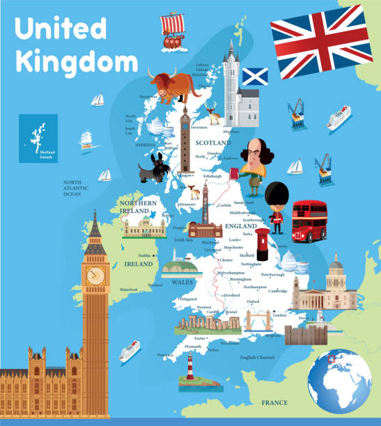
Vector uk cartoon map http://legacy.lib.utexas.edu/maps/europe/united_kingdom_pol87.jpg

Vector uk cartoon map http://legacy.lib.utexas.edu/maps/europe/united_kingdom_pol87.jpg

Brighton, England-18 October,2018: The entrance of Preston Park public playground soccer field in the afternoon with location map at Brighton and Hove, UK.

http://farm8.staticflickr.com/7189/6818724910_54c206caf8.jpg
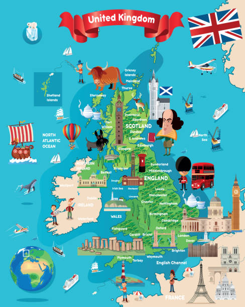
Vector uk cartoon map http://legacy.lib.utexas.edu/maps/europe/united_kingdom_pol87.jpg

3D Render of a Topographic Map of Blackpool City, UK. All source data is in the public domain. Contains modified Copernicus Sentinel data (Jun 2018) courtesy of ESA. URL of source image: https://scihub.copernicus.eu/dhus/#/home. Relief texture SRTM data courtesy of NASA. URL of source image: https://search.earthdata.nasa.gov/search/granules/collection-details?p=C1000000240-LPDAAC_ECS&q=srtm%201%20arc&ok=srtm%201%20arc

3D Render of a Topographic Map of Blackpool City, UK. All source data is in the public domain. Contains modified Copernicus Sentinel data (Jun 2018) courtesy of ESA. URL of source image: https://scihub.copernicus.eu/dhus/#/home. Relief texture SRTM data courtesy of NASA. URL of source image: https://search.earthdata.nasa.gov/search/granules/collection-details?p=C1000000240-LPDAAC_ECS&q=srtm%201%20arc&ok=srtm%201%20arc

West Virginia county map outline vector in gray color

Vector uk cartoon maphttp://legacy.lib.utexas.edu/maps/europe/united_kingdom_pol87.jpg

3D Render of a Topographic Map of Manchester, England. All source data is in the public domain. Color and Water texture: Contains modified Copernicus Sentinel data (2021) courtesy of ESA. URL of source image: https://dataspace.copernicus.eu/explore-data/data-collections/sentinel-data/sentinel-2 Relief texture: SRTM data courtesy of NASA JPL (2020). URL of source image: https://lpdaac.usgs.gov/products/srtmgl1v003/

Vector uk cartoon maphttp://legacy.lib.utexas.edu/maps/europe/united_kingdom_pol87.jpg

Map of Webster County - Georgia, isolated on a blank background and with his name on a red ribbon. Vector Illustration (EPS file, well layered and grouped). Easy to edit, manipulate, resize or colorize. Vector and Jpeg file of different sizes.

Maps of Fillmore County - Minnesota, on blue and red backgrounds. Four map versions included in the bundle: - One map on a blank blue background. - One map on a blue background with the word "Democrat". - One map on a blank red background. - One map on a red background with the word "Republican". Vector Illustration (EPS file, well layered and grouped). Easy to edit, manipulate, resize or colorize. Vector and Jpeg file of different sizes.

Map of Franklin County - Idaho, in a trendy vintage style. Beautiful retro illustration with old textured paper and light rays in the background (colors used: blue, green, beige and black for the outline). Vector Illustration (EPS file, well layered and grouped). Easy to edit, manipulate, resize or colorize. Vector and Jpeg file of different sizes.

Map of Fillmore County - Minnesota folded with design elements. Blue map with grid lines, isolated on a blank background. Included in the illustration: Map pins, pushpins, marbles, stars, speech bubbles, people, and a map of the United States. Vector Illustration (EPS file, well layered and grouped). Easy to edit, manipulate, resize or colorize. Vector and Jpeg file of different sizes.

Map of Webster County - Georgia, with a large group of people. The faces are blue and red and represent patriots. The color blue for the Democratic Party and the color red for the Republican Party. Conceptual creative map, can symbolize the unity, cooperation, teamwork, patriotism... Vector Illustration (EPS file, well layered and grouped). Easy to edit, manipulate, resize or colorize. Vector and Jpeg file of different sizes.

Map of Fillmore County - Minnesota, with a large group of people. The faces are blue and red and represent patriots. The color blue for the Democratic Party and the color red for the Republican Party. Conceptual creative map, can symbolize the unity, cooperation, teamwork, patriotism... Vector Illustration (EPS file, well layered and grouped). Easy to edit, manipulate, resize or colorize. Vector and Jpeg file of different sizes.

Idaho US State Vector Road Map Grey. All source data is in the public domain. Roads, Water, Regions, Urban Areas: Made with Natural Earth. https://www.naturalearthdata.com/downloads/10m-physical-vectors/ https://www.naturalearthdata.com/downloads/10m-cultural-vectors/

Map of Fillmore County - Minnesota for your own design. Three maps with editable stroke included in the bundle: - One black map on a white background. - One line map with only a thin black outline in a line art style (you can adjust the stroke weight as you want). - One map on a blank transparent background (for change background or texture). The layers are named to facilitate your customization. Vector Illustration (EPS file, well layered and grouped). Easy to edit, manipulate, resize or colorize. Vector and Jpeg file of different sizes.

Map of Preston County - West Virginia for your own design. Three maps with editable stroke included in the bundle: - One black map on a white background. - One line map with only a thin black outline in a line art style (you can adjust the stroke weight as you want). - One map on a blank transparent background (for change background or texture). The layers are named to facilitate your customization. Vector Illustration (EPS file, well layered and grouped). Easy to edit, manipulate, resize or colorize. Vector and Jpeg file of different sizes.

Map of Fillmore County - Minnesota, isolated on a blank background and with his name on a red ribbon. Vector Illustration (EPS file, well layered and grouped). Easy to edit, manipulate, resize or colorize. Vector and Jpeg file of different sizes.

Map of Fillmore County - Minnesota, on a blue and red colored background. The blue color represents the Democratic Party and the red color represents the Republican Party. White stars are placed above and below the map. Vector Illustration (EPS file, well layered and grouped). Easy to edit, manipulate, resize or colorize. Vector and Jpeg file of different sizes.

Maps of Webster County - Georgia, on blue and red backgrounds. Four map versions included in the bundle: - One map on a blank blue background. - One map on a blue background with the word "Democrat". - One map on a blank red background. - One map on a red background with the word "Republican". Vector Illustration (EPS file, well layered and grouped). Easy to edit, manipulate, resize or colorize. Vector and Jpeg file of different sizes.

3D Map of Preston County - West Virginia, isolated on a blank and gray background, with a dropshadow. Vector Illustration (EPS file, well layered and grouped). Easy to edit, manipulate, resize or colorize. Vector and Jpeg file of different sizes.

Lancashire (United Kingdom, England, Non-metropolitan county, shire county) map vector illustration, scribble sketch Lancs. map

Map of Fillmore County - Minnesota, with a realistic paper cut effect isolated on white background. Trendy paper cutout effect. Vector Illustration (EPS file, well layered and grouped). Easy to edit, manipulate, resize or colorize. Vector and Jpeg file of different sizes.

Map of Preston County - West Virginia, with a realistic paper cut effect isolated on white background. Trendy paper cutout effect. Vector Illustration (EPS file, well layered and grouped). Easy to edit, manipulate, resize or colorize. Vector and Jpeg file of different sizes.

WV Preston County Vector Map Green. All source data is in the public domain. U.S. Census Bureau Census Tiger. Used Layers: areawater, linearwater, cousub, pointlm.

Large and detailed map of Webster county in Georgia, USA.

Large and detailed map of Webster county in Georgia, USA.

Map of Franklin County - Idaho, isolated on a blank background and with his name on a red ribbon. Vector Illustration (EPS file, well layered and grouped). Easy to edit, manipulate, resize or colorize. Vector and Jpeg file of different sizes.

Map of Franklin County - Idaho, with a large group of people. The faces are blue and red and represent patriots. The color blue for the Democratic Party and the color red for the Republican Party. Conceptual creative map, can symbolize the unity, cooperation, teamwork, patriotism... Vector Illustration (EPS file, well layered and grouped). Easy to edit, manipulate, resize or colorize. Vector and Jpeg file of different sizes.

Large and detailed map of Webster county in Georgia, USA.

Large and detailed map of Webster county in Georgia, USA.

Map of Webster County - Georgia, with a realistic paper cut effect isolated on white background. Trendy paper cutout effect. Vector Illustration (EPS file, well layered and grouped). Easy to edit, manipulate, resize or colorize. Vector and Jpeg file of different sizes.

Map of Fillmore County - Minnesota, in a trendy vintage style. Beautiful retro illustration with old textured paper and light rays in the background (colors used: blue, green, beige and black for the outline). Vector Illustration (EPS file, well layered and grouped). Easy to edit, manipulate, resize or colorize. Vector and Jpeg file of different sizes.

Map of Webster County - Georgia, for your own design. Four maps with editable stroke included in the bundle: - One black map on a white background. - One blank map on a black background. - One white map with shadow on a blank background (for easy change background or texture). - One line map with only a thin black outline (in a line art style). The layers are named to facilitate your customization. Vector Illustration (EPS file, well layered and grouped). Easy to edit, manipulate, resize or colorize. Vector and Jpeg file of different sizes.

Map of Webster County - Georgia for your own design. Three maps with editable stroke included in the bundle: - One black map on a white background. - One line map with only a thin black outline in a line art style (you can adjust the stroke weight as you want). - One map on a blank transparent background (for change background or texture). The layers are named to facilitate your customization. Vector Illustration (EPS file, well layered and grouped). Easy to edit, manipulate, resize or colorize. Vector and Jpeg file of different sizes.

Map of Preston County - West Virginia, on two blue and red rubber stamps. Two versions included in the bundle: - One blue stamp with the map in the middle and the word "Democrat" around. - One red stamp with the map in the middle and the word "Republican" around. And also two blue and red banners with the name of the county. Vector Illustration (EPS file, well layered and grouped). Easy to edit, manipulate, resize or colorize. Vector and Jpeg file of different sizes.

Map of Preston County - West Virginia, in a trendy vintage style. Beautiful retro illustration with old textured paper and light rays in the background (colors used: blue, green, beige and black for the outline). Vector Illustration (EPS file, well layered and grouped). Easy to edit, manipulate, resize or colorize. Vector and Jpeg file of different sizes.

3D Map of Webster County - Georgia, isolated on a blank and gray background, with a dropshadow. Vector Illustration (EPS file, well layered and grouped). Easy to edit, manipulate, resize or colorize. Vector and Jpeg file of different sizes.

Map of Preston County - West Virginia, isolated on a blank background and with his name on a red ribbon. Vector Illustration (EPS file, well layered and grouped). Easy to edit, manipulate, resize or colorize. Vector and Jpeg file of different sizes.


