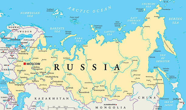
Russia political map with capital Moscow, national borders, important cities, rivers and lakes. English labeling and scaling. Illustration.
Browse 70+ barents sea map stock illustrations and vector graphics available royalty-free, or start a new search to explore more great stock images and vector art.
Russia political map with capital Moscow, national borders, important cities, rivers and lakes. English labeling and scaling. Illustration.

Arctic Ocean region, north of mainland Europe, gray political map. From eastern Greenland to Svalbard, to Franz Josef Land, with parts of the countries Iceland, Norway, Sweden, Finland and Russia.
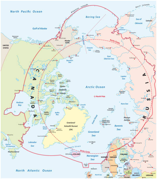
Arctic Ocean map with North Pole and Arctic Circle. Arctic region map with countries, national borders, rivers and lakes. Map without sea ice. English labeling and scaling.

Murmansk Oblast and Kola Peninsula, political map. Federal subject of Russia, part of Lapland region, bordering Norway and Finland. With Murmansk, most important port city of Russia on Arctic Ocean.
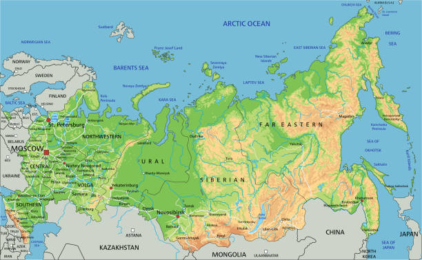
High detailed Russia physical map with labeling. Organized vector illustration on seprated layers.

Arctic Ocean region north of mainland Europe, political map. From the eastern part of Greenland to Svalbard to Franz Josef Land, with parts of the countries Iceland, Norway Sweden, Finland and Russia.

Arctic Circle Region detailed editable map with regions cities and towns, geographic sites. Vector EPS-10 file

Novaya Zemlya, archipelago in northern Russia, gray political map. Situated in the Arctic Ocean, consisting of Severny Island and Yuzhny Island. Nuclear weapons testing venue during much of Cold War.
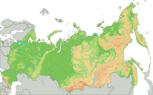
High detailed Russia physical map. Organized vector illustration on seprated layers.

Svalbard Political Map with capital Longyearbyen, a Norwegian archipelago in the Arctic Ocean, formerly known by its Dutch name Spitsbergen. English labeling and scaling. Illustration.

Sápmi, Lapland, political map. A cultural region in Northern and Eastern Europe, including the northern parts of Fennoscandia, stretching over the four countries Norway, Sweden, Finland and Russia.
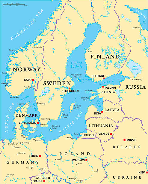
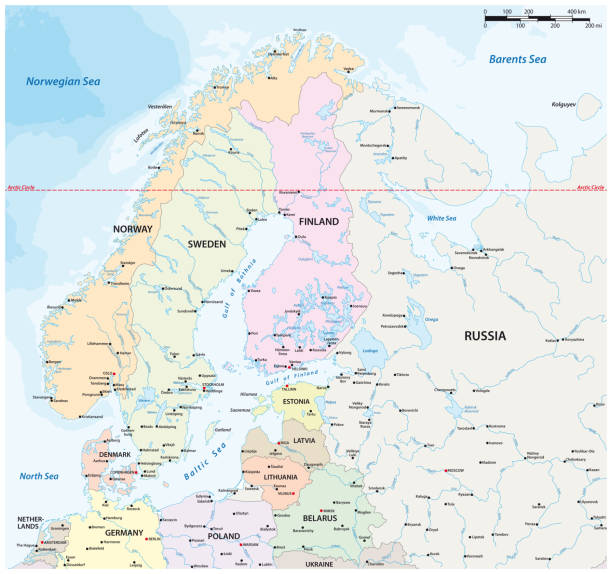
Baltic Sea Area Political Map with capitals, national borders, important cities, rivers and lakes. English labeling and scaling. Illustration.
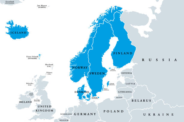
Scandinavia, political map. A subregion in Northern Europe, most commonly referring to Denmark, Norway, and Sweden, and more broadly also with Aland, Faroe Islands, Finland and Iceland. Illustration.

Schematic vector map of the Northeast Passage (NEP).
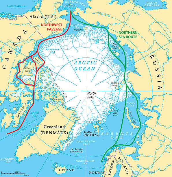
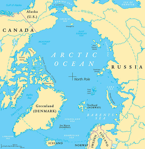
Arctic Ocean sea routes map with Northwest Passage and Northern Sea Route. Arctic Region map with countries, national borders, rivers, lakes and average minimum extent of sea ice. English labeling and scaling.
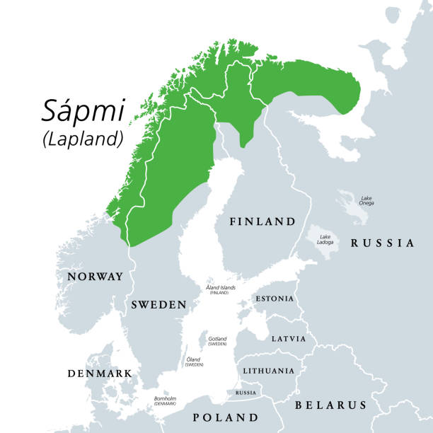
Sapmi, Lapland, gray political map. Cultural region in Northern and Eastern Europe, including the northern parts of Fennoscandia, stretching over the four countries Norway, Sweden, Finland and Russia.

High detailed Russia road map with labeling. Organized vector illustration on seprated layers.

Eastern Europe and Western Asia, political map, with capitals, borders, lakes and rivers. With the Black Sea, Caspian Sea, European Russia, and with a small part of Central Asia. Illustration. Vector.

Most precise vector illustration of map of the world. Every state is on separate sub-layer so it makes it easy to edit or select. No auto-tracing! Everything is drawn by the hand.

High detailed Russia road map with labeling. Organized vector illustration on seprated layers.

Isometric Antarctica station or polar station with buildings, meteorological research measurement tower, vehicles, helipad Vector Illustration.

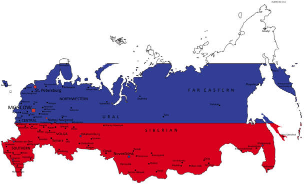
Colorful Russia political map with clearly labeled, separated layers. Vector illustration.

Isometric Antarctica station or polar station with buildings, meteorological research measurement tower, vehicles, helipad Vector Illustration.

Highly detailed vector map of Baltic Sea Area with states, capitals and big cities.

Isometric Antarctica station or polar station with buildings, meteorological research measurement tower, vehicles, helipad and icebreaker Vector Illustration
Highly detailed vector map of Baltic Sea Area with states, capitals and big cities.

Alaska Map http://maps.lib.utexas.edu/maps/united_states/fed_lands_2003/alaska_2003.pdf

Isometric Antarctica station or polar station with buildings, meteorological research measurement tower, vehicles, helipad and icebreaker

Highly Detailed Russia Silhouette map. Organized vector illustration on seprated layers.

High detailed Russia physical map. Organized vector illustration on seprated layers.

High detailed Russia road map with labeling. Organized vector illustration on seprated layers.

Russia - Highly detailed editable political map with labeling. Organized vector illustration on seprated layers.

Russia road and highway map. Organized vector illustration on seprated layers.
Highly detailed vector map of Finland with states, capitals and big cities.

Highly detailed vector map of Finland with states, capitals and big cities.

Precise vector illustration of map of the world. Every state is on separate sub-layer so it makes it easy to edit or select.
Russia highly detailed political map with national flag. Organized vector illustration on seprated layers.

Murmansk Oblast, Kola Peninsula, gray political map. Federal subject of Russia, part of Lapland region, bordering Norway and Finland. With Murmansk, most important port city of Russia on Arctic Ocean.

Greenland and Arctic Region, political map of the largest island of the world, situated between Arctic and Atlantic ocean, east of the Canadian Arctic Archipelago. With Iceland, and Svalbard. Vector

Wind Speed Weather Map of Storm Jocelyn affecting Northern Europe on January 22, 2024. Made with data from Global Forecast System GFS. All source data is in the public domain. Wind Speed data: NCEP GFS 0.25 Degree Global Forecast Grids Historical Archive. Countries and Boundaries: Made with Natural Earth.

Eastern Europe and Western Asia, multi colored political map with capitals, borders and largest cities. With Black Sea, Caspian Sea, European Russia, and a small part of Central Asia. Illustration.
Highly detailed editable political Russia map. Organized vector illustration on seprated layers.

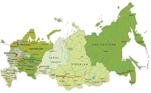
High detailed Russia physical map with labeling. Organized vector illustration on seprated layers.
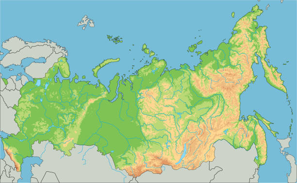
High detailed Russia physical map. Organized vector illustration on seprated layers.

Greenland and part of the Arctic Region, gray political map. Largest island of the world situated between the North Atlantic Ocean and the Arctic Ocean, east of the Canadian Arctic Archipelago. Vector

Earth vector buttons. Elements are grouped separate objects. Illustration is made with gradient. Created in illustrator cs3 on 12. july 2008. Hi-res. jpeg included.

Highly detailed editable political Russia map. Organized vector illustration on seprated layers.

Novaya Zemlya, archipelago in northern Russia, political map. Situated in Arctic Ocean, between Barents Sea and Kara Sea, consisting of Severny Island and Yuzhny Island. Nuclear weapons testing venue.

Alaska Map http://maps.lib.utexas.edu/maps/united_states/fed_lands_2003/alaska_2003.pdf

Wind Speed Weather Map of a windstorm over the Barents Sea in the north of Russia on September 23, 2025. Made with data from Global Forecast System GFS. All source data is in the public domain. Wind Speed data: NCEP GFS 0.25 Degree Global Forecast Grids Historical Archive. Countries and Boundaries: Made with Natural Earth.

Alaska Polar Bear Stamp http://maps.lib.utexas.edu/maps/united_states/fed_lands_2003/alaska_2003.pdf